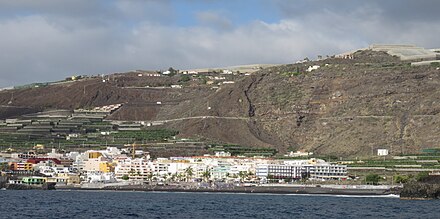
Puerto Naos
| Los Llanos de Aridane municipality: Puerto Naos |
||
|---|---|---|
 Puerto Naos
|
||
| coat of arms | Map of the Canary Islands | |
 Help on coat of arms |
|
|
| Basic data | ||
| Autonomous Community : |
|
|
| Province : | Santa Cruz de Tenerife | |
| Island: | La Palma | |
| Coordinates | 28 ° 35 ′ N , 17 ° 55 ′ W | |
| Residents : | 895 (2016) INE | |
| Postal code : | E-38769 | |
| Area code: | 38024000800 | |
Puerto Naos is a municipality part of the community Los Llanos on to Spain belonging Canary Island of La Palma . Its central place with the same name Puerto Naos is one of the most important tourist centers of the island with an extensive bathing beach - next to Los Cancajos .
geography
The municipality of Puerto Naos with an elongated stretch of coast is located in the south of the municipality of Los Llanos and is bounded by the municipalities, in the north by Tazacorte and in the south by Fuencaliente . The area was expanded significantly by lava flows from two volcanic eruptions, which flowed from the steeply rising Cumbre Vieja to the sea. In 1585, the volcanic eruption of the Tajuya between Puerto Naos and Charco Verde created approx. 150 hectares and in 1712 approx. 6.4 hectares of new land was created by that of El Charco near El Remo .
Its two beaches are important for tourism, the 600 meter long beach in Puerto Naos and Playa de Charco Verde , a bay protected between volcanic rocks between the towns of Puerto Naos and El Remo .
In the south, in the immediate vicinity of the coast, there is the El Remo settlement with about 108 inhabitants, it is one of the protected landscapes of Tamanca on La Palma .
The entire coastline of Puerto Naos is part of the marine reserve established on La Palma since 2001 with a coastline of 15 kilometers.
history
Before tourism became the main source of income, the inhabitants lived from fishing and growing bananas.
During the Cold War , under the guise of whale research by the Palisades Geophysical Institute at Columbia University in 1963 , the US military built a submarine listening station that was part of more than thirty monitoring stations of the American SOSUS . The aim was to track down submarines of the USSR. In May 1968 it took part in the search for the American nuclear submarine USS Scorpion (SSN-589) , which sank on May 22, 1968, 400 miles southwest of the Azores with 99 men on board.
A week before the Teneguía volcanic eruption on October 31, 1971, the measuring station recorded intense underwater noises that indicated the impending volcanic eruption in the south of the island. The data collected have been sent to the Spanish authorities. After the monitoring station was finally closed in 1976, the empty buildings stood until they were demolished in 2007.
With the new airport on La Palma , where charter flights from mainland Europe could land for the first time in the 1980s, construction activity increased on La Palma, including Puerto Naos, so that the former fishing village developed into a pure tourist settlement within a few years .
Population development
Source: Spanish Statistical Office
| 2000 | 2001 | 2002 | 2003 | 2004 | 2005 | 2006 | 2007 | 2008 | 2009 | 2010 | 2011 | 2012 | 2013 | 2014 | 2015 | 2016 |
|---|---|---|---|---|---|---|---|---|---|---|---|---|---|---|---|---|
| 737 | 852 | 871 | 921 | 853 | 874 | 849 | 848 | 877 | 914 | 941 | 979 | 970 | 946 | 899 | 888 | 895 |
economy
tourism
The main source of income for the community is tourism through various apartments, a large hotel complex as well as restaurants, bars and shops. In addition to the good bathing opportunities on the black sand beach, which has been awarded the Blue Flag , there is the possibility of paragliding , mountain biking and diving.
traffic
There is an hourly direct bus connection from Los Llanos, sometimes continuing to El Remo. The city of Los Llanos is about 15 minutes away by car, the airport and the capital Santa Cruz de La Palma can be reached in 45 minutes.
Personalities
- Rosana Simón (* 1989), Spanish Taekwondoin
Web links
Individual evidence
- ^ R. Olzem: Volcan Jedey or Tajuya
- ^ R. Olzem: Volcano El Charco
- ↑ Tamanca Protected Landscape Area , Reserva Mundial de la Biosfera La Palma.
- ↑ Reserva Marina Isla de La Palma , Reserva Mundial de la Biosfera La Palma.
- ↑ Land use plan - Marine Reserve , La Reserva Marina de la Isla cuenta con una nueva regulación que refuerza su protección.
- ↑ La Palma y el mar
- ↑ Lars Gerhardts: Development of tourist demand on La Palma , La Palma Current - Calendar sheet for August 2005.
- ^ Instituto Nacional de Estadística .


