
Bastione (Riva del Garda)
| Bastione | ||
|---|---|---|
 South and east side |
||
| Creation time : | 1508 | |
| Castle type : | Hilltop castle | |
| Conservation status: | Ruin, restored | |
| Place: | Riva del Garda | |
| Geographical location | 45 ° 53 '5.6 " N , 10 ° 50' 9.3" E | |
| Height: | 220 m slm | |
|
||

The Bastione is part of a former Venetian fortress from the 16th century in Riva del Garda in Trentino .
location
The ruin is located to the west about 150 meters above the historic town center of Riva on the slopes of the Cima Sat. From the town, a paved footpath leads in several serpentines in about 20 minutes to the former fortress with great views.
history
The bastione was built during the Venetian rule of Rivas (1440–1509) by an unknown builder on a previously undeveloped area. He was a defensive bulwark to protect the city and its now getting on in years yet from the Middle Ages derived fortification was designed. The construction, which began at the end of 1507, falls into the final phase of the Venetian era of Rivas and was intended to protect the city on the shores of Lake Garda from attacks from the north.
The complex, which in addition to the characteristic roundabout also consisted of several other structures, most of which are no longer preserved, was completed within a very short time. As early as May 1509, after the battle of Agnadello and the resulting withdrawal of the Venetians from present-day Trentino, the building fell into the hands of the Prince-Bishop of Trento, George III. by Neideck .
The bastione was still operational and well preserved in the 17th century. Only the gun emplacements were no longer oriented to the north and east, as originally in the tower, due to the changed threat situation, but rather on the walled forecourt facing south. The dilapidated and neglected condition of the complex has been documented since the middle of the 17th century.
The final decline is linked to the withdrawal of the French during the War of the Spanish Succession . On October 12, 1703, the French, under the command of General Vendôme , mined both the Bastione and the Rocca - the moated castle of Riva - and blew up both.
In the following years the bastione slowly fell into disrepair and larger and larger pieces of the wall collapsed. In the 1950s, the mountain station of a chairlift was built on the southern edge of the former forecourt , which connected Riva with the Bastione and which now houses an excursion restaurant, so that the original structure of the entire complex is difficult to see. At the end of the 1950s, the ruin was restored for the first time and the tower crown was consolidated and a breach in the southern outer wall next to the lower entrance was bricked up again. Between 2002 and 2008 the Autonomous Province of Trento had the facility extensively restored, with the interior of the tower being made accessible again with the help of a steel staircase.
description
The originally larger building once consisted of a central structure, the three-story roundabout made of white quarry stone , a forecourt surrounded by a defensive and retaining wall, two smaller towers and a porch south of the main tower. In addition to the roundabout, only parts of the rest of the complex have been preserved, such as the retaining walls of the forecourt and remnants of the porch adjacent to the south. Of the two smaller towers, the angular tower that was once located at the north end of the complex has completely disappeared, while the southern semicircular tower has been partially integrated into the former cable car station.
The semicircular gun emplacements on the top floor of the roundabout could completely cover the area in front of the northern city wall. While the middle and lower parts of the tower are relatively well preserved, the original shape can no longer be seen in the upper area. The wall openings are on the side of the roundabout facing the valley. The main entrance to the tower is on the north-western side of the mountain. The stone coat of arms of Bishop George III adorns the east side . von Neideck the upper outer wall. Some of the brackets attached to the upper edge on the north and east side indicate formerly existing bay windows and allow the conclusion that the roundabout must have been a bit higher in the past.
In addition to the main entrance, there is a second entrance on the southeast side, which leads to the lowest of the three floors. Access is from the former forecourt via a few stone steps, which first lead into the remains of the adjoining building to the south and from there to the entrance. The interior of the tower can hardly convey the earlier original condition, as most of the ceilings have not been preserved. In the basement there were three vaults separated by walls, two of which were used as storage and one as a water cistern . The water was led into the cistern via stone channels, some of which have still been preserved. An earlier access from the basement to the floor above cannot be proven with certainty due to the insufficient traces.
The second floor can only be reached via the main entrance on the mountain side, which was secured with two launchers . An equally to the defense of the entrance and right built loophole was later walled up, nor be seen from the outside as a former leading away from the main entrance towards the west and then south outer wall that protected the entrance also. On the other hand, the tower wall around three meters thick is well preserved. The system's logistics were located on the second floor of the roundabout . Here are the remains of a fireplace and a small chamber that probably served as a storage room. A steel staircase leads from the second floor to the upper third floor, where the gun emplacements were once located. The loopholes facing north and east are relatively well preserved. On the other hand, the floor between the second and third floors, on which the guns were withdrawn from the firing position, is no longer there. The outer wall in the upper area also partially collapsed, especially on the south and west sides of the tower.
photos
 Entrance to the north-west side with a litter box above and clearly recognizable bay console on the left
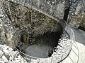 First and second level with stairs to the former gun level
 Coat of arms of Bishop Georg von Neideck on the outer wall
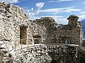 Remains of the gun level
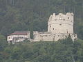 Overall view with the clearly recognizable retaining walls of the forecourt


literature
- Cinzia D'Agostino: Il "Bastione" di Riva del Garda. Una fortezza veneziana del XVI secolo agli estremi confini di terraferma in Trentino in: Il restauro dei castelli: analisi e interventi sulla architetture fortificate. Conoscere per restaurare , Atti dei seminari in archeologia dell'architettura, Provincia Autonoma di Trento, Trento 2007.
- Aldo Gorfer: Guida dei castelli del Trentino , Saturnia, Trento 1965.
Web links
Individual evidence
- ^ Cinzia D'Agostino: Il "Bastione" di Riva del Garda. Una fortezza veneziana del XVI secolo agli estremi confini di terraferma in Trentino pp. 41–42
- ^ Cinzia D'Agostino: Il "Bastione" di Riva del Garda. Una fortezza veneziana del XVI secolo agli estremi confini di terraferma in Trentino pp. 43–45
- ↑ Information on the restoration of the Bastione in Italian , accessed on October 9, 2017.
- ^ Cinzia D'Agostino: Il "Bastione" di Riva del Garda. Una fortezza veneziana del XVI secolo agli estremi confini di terraferma in Trentino p. 48
- ^ Cinzia D'Agostino: Il "Bastione" di Riva del Garda. Una fortezza veneziana del XVI secolo agli estremi confini di terraferma in Trentino pp. 46–47