
Bay of Islands Coastal Park

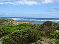
The Bay of Islands Coastal Park National Park is a 32-kilometer coastal reserve in the south of the state of Victoria , Australia , on the Great Ocean Road (road B100), which was established in 1997 from a number of earlier smaller protected areas.
location
The 32 km long and 950 hectare coastal park is located between the cities of Peterborough and Warrnambool west of the Port Campbell National Park and consists of the Bay of Martyrs and the Bay of Islands as well as the Three Mile Beach and Childers Cove. The park extends to areas above the low water mark of the former nature reserves Bay of Islands Coastal Reserve , Childers Cove Foreshore Reserve and Islands Coastal Reserve east of Killeens Road.
history
Most of the Bay of Islands coastal park was temporarily open to the public after 1873. In 1978, the Land Conservation Council (LCC) recommended that the area be established as a coastal park, which became permanent in 1982 with the CrownLand (Reserves) Act 1978 and became known as the Bay of Islands Coastal Reserve. As a result of the National Parks (Amendment) Act 1997 (Vic.), This area above the low water mark, the Childers Cove Foreshore Reserve and some neighboring areas were proclaimed the Bay of Islands Coastal Park on June 4, 1997.
The Coastal Park Bay of Islands Coastal Park (as well as the adjacent Port Campbell National Park ) in the Category II: National Park ( National Park :) and Category III or Natural Monument Feature ( natural monument ) of the World Conservation Union IUCN out.
- Bay of Islands Coastal Park
Bay of Islands

Bay of Martyrs (Massacre Bay)

Childers Cove

Bay of Islands


.jpg)

Special attraction
The emerging colonies like Victoria and New South Wales were dependent on supplies from Europe. One of the busiest shipping routes was the Bass Strait between South Australia and Tasmania , which ran south of the Great Ocean Road and posed many risks for the ships because of its rocky nature. Just like the Loch Ard Gorge ship cemetery (in the neighboring Port Campbell National Park ), one site has also been preserved in the Bay of Islands Coastal Park, Halladale Point in the Bay of Martyrs , where the ship Falls of Halladale sank in 1908 .
Individual evidence
- ↑ a b Port Campbell National Park and Bay of Islands Coastal Park September 1998. Management Plan , Portal Parks Victoria of the Government of Victoria, online (archived) at: parkweb.vic.gov.au / ...
- ↑ General Technical Report RMRS, editions 142–144, University of Michigan 1998, p. 57, online at: books.google.de / ...
- ↑ Bay of Islands Coastal Park , Portal Parks Victoria of the Government of Victoria, online (archived) at: parkweb.vic.gov.au / ...
- ↑ Port Campbell National Park & Bay of Islands Coastal Park , Portal Parks Victoria of the Government of Victoria, online (archived) at: parkweb.vic.gov.au / ...
Coordinates: 38 ° 29 ′ 21.2 " S , 142 ° 40 ′ 23.6" E