
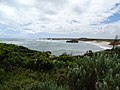
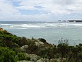
Bay of Martyrs

The two and a half kilometers long bay Bay of Martyrs is one of the attractions on the Great Ocean Road in the state of Victoria , Australia . The Bay of Martyrs including Massacre Bay is located in the Bay of Islands Coastal Park, southeast of the Bay of Islands and northwest of Peterborough . In addition to Massacre Bay, Crofts Bay and Wild Dog Cove are also included in the Bay of Martyrs. The place Halladale Point (also Point Halladale ) is located at the southern end of Massacre Bay towards Peterborough.
Massacre Bay
The name of the bay Massacre Bay (just like Bay of Martyrs or Massacre Point) is derived from an event of the 19th century. After the European settlers advanced into the coastal area on the Great Ocean Road in the 1840s , there were several violent encounters with various Aboriginal tribes , in which they were ultimately defeated. One of these clashes happened in Massacre Bay. Here the settlers are said to have pushed a large group of male Aborigines of the Girai wurrung tribe (also known as Kirrae Wuurong) down from the cliffs, which are up to ten meters high. Women and children are said to have been drowned in the nearby swamp. Although there is no written evidence of the incident in Massacre Bay and everything is based on oral traditions of the indigenous people, this incident is extensively represented in the literature as a given. Among other things, a sharp decline in the population is pointed out.
A memorial was erected on nearby Massacre Hill to commemorate what happened.
- Bay of Martyrs and Massacre Bay


Halladale Point
The growing British convict colonies in Australia relied on ships from Europe to supply them. The Bass Strait became a major shipping route, with some ships capsizing in its straits. The whole coast is today Shipwreck Coast (Coast of shipwrecks) called.
Similar to the bay of Loch Ard Gorge east of Port Campbell , Halladale Point is named after a shipwreck, namely after the three-masted "Falls of Halladale". The ship, built in Scotland in 1886, set sail for Australia on St. Patrick's Day in 1908. On November 14, 1908, during the passage through Bass Strait near Peterborough, the ship steered towards a reef, probably due to a navigation error. In contrast to the sinking of the Loch Ard ship in 1878, all 29 sailors were able to save themselves, the ship was lost.
See also
- List of Aboriginal massacres
- Great Ocean Road
- Loch Ard Gorge , site of the sinking of Loch Ard (1878)
Individual evidence
- ↑ a b c Bay of Martyrs - History and Nature on the Great Ocean Road , online uf: greatoceanroadmelbournetours.com.au / ... Accessed March 29, 2020. (English)
- ↑ Peterborough , in: The Sydney Morning Herald, February 8, 2004, online at: smh.com.au / ... Accessed March 29, 2020. (English)
- ↑ Great Ocean Road , Bay of Islands Coastal Park section , private website, online at: australiaforeveryone.com.au / ... Accessed March 29, 2020. (English)
- ↑ Massacre Hill , Portal Monuments Australia, online at: monumentaustralia.org.au / ... Accessed March 29, 2020. (English)
- ↑ a b Port Campbell National Park & Bay of Islands Coastal Park , Portal Parks Victoria of the Government of Victoria, online (archived) at: parkweb.vic.gov.au / ... (English, PDF; 1.5 MB)
- ↑ Bay of Islands Coastal Park , Portal Parks Victoria of the Government of Victoria, online (archived) at: parkweb.vic.gov.au / ... (English)
- ↑ The "Falls of Halladale" , Portal Ship Modelers Association, online (archived) at: web.archive.org / ... (English)
Coordinates: 38 ° 35 ′ 54.1 ″ S , 142 ° 51 ′ 32.7 ″ E