
Great Ocean Road
| Great Ocean Road | |||||||||||||||||||||||||||||||||||||||||||
|---|---|---|---|---|---|---|---|---|---|---|---|---|---|---|---|---|---|---|---|---|---|---|---|---|---|---|---|---|---|---|---|---|---|---|---|---|---|---|---|---|---|---|---|

|
|||||||||||||||||||||||||||||||||||||||||||
| map | |||||||||||||||||||||||||||||||||||||||||||
 |
|||||||||||||||||||||||||||||||||||||||||||
| Basic data | |||||||||||||||||||||||||||||||||||||||||||
| Operator: | VicRoads | ||||||||||||||||||||||||||||||||||||||||||
| Start of the street: |
Torquay ( 38 ° 20 ' S , 144 ° 19' O ) |
||||||||||||||||||||||||||||||||||||||||||
| End of street: |
Allansford ( 38 ° 23 ′ S , 142 ° 37 ′ E ) |
||||||||||||||||||||||||||||||||||||||||||
| Overall length: | 243 km | ||||||||||||||||||||||||||||||||||||||||||
|
States : |
|||||||||||||||||||||||||||||||||||||||||||
 |
|||||||||||||||||||||||||||||||||||||||||||
|
Course of the road
|
|||||||||||||||||||||||||||||||||||||||||||


The Great Ocean Road (Road B100) is a 150 mile long road that runs along Australia's south coast between Torquay and Allansford in the state of Victoria . It is one of the most famous scenic routes among tourists in Australia. One study found that between 6.5 and 7.5 million visitors come to the Great Ocean Road region annually, with an additional 2.4 million coming by 2030.
This road was inscribed on the Australian National Heritage List on April 7, 2011 because of its historical and cultural importance .
history
Before the Europeans came to what is now the Great Ocean Road , two tribes of the Aborigines lived there . The Watha Wurrung lived in the eastern end and the Gadubanud then further west, almost as far as Warrnambool. When one of their women was kidnapped in the Gadubanud area of Cape Otway , they killed the European kidnapper in an argument. In revenge, the Europeans committed the Blanket Bay massacre of seven Gadubanuds on the River Aire , which is also interpreted as a strategic measure to clean up the area and to secure the lighthouses there. Historic Aboriginal rubbish pits are located along the coastline to prove their presence.
The first idea of a road along the south coast of Victoria dates back to 1864. This was primarily intended to connect the numerous coastal towns and fishing ports along the coast by land, which until then could only be reached by ship. Concrete planning and exploration for a possible course of the route did not take place until 1918. In 1919 construction of the road began. The work was carried out by 3000 soldiers who returned home after the end of the First World War . For them, the construction of the road served on the one hand as a job creation measure by the government of Victoria, on the other hand it was also the erection of a war memorial to commemorate the comrades who died in the war.
Due to the special geographical and geological conditions, the construction was very difficult and lengthy. The first section between Torquay and Lorne was completed in 1922. Next came individual sections that were built from the west. The last and most complicated section was the line between Apollo Bay and Lorne, it was completed in 1932. Since then, the route has been continuously passable.
One of the best known rock formations in Australia is the Island Archway , an arch over 25 m high that collapsed on June 10, 2009.
course

South of Geelong , the Surfcoast Highway branches off from the Princes Highway and leads to Torquay on the country's coast. This first section is often considered part of the Great Ocean Road . Its official start is outside of Torquay.
From Torquay, the Great Ocean Road follows the coast in a south-westerly direction. It connects the surfing paradise Bells Beach and the resorts of Anglesea , Lorne and Apollo Bay. On this section, the mountains of the hinterland partially extend into the sea and the Great Ocean Road meanders along its edges in a very winding course. This offers numerous opportunities for great views of the Bass Strait and the Southern Ocean , sandy beaches and cliffs that drop steeply to the sea. Between Anglesea and Lorne are Aireys Inlet and Fairhaven, which are known for the split-point lighthouse built in 1891 and the wild Fairhaven Beach . East of Aireys Inlet also begins the Great Otway National Park, which extends over half the length of the B 100 . About 40 kilometers southwest is Kennett River , which is frequented by many tourists on Gray River Road to watch koalas . About 20 kilometers further is Apollo Bay , where the 104-kilometer Great Ocean Walk begins.
To the west of Apollo Bay , the Great Ocean Road runs inland and passes through Great Otway National Park , which is characterized by temperate rainforests . A side street leads to Cape Otway and the Cape Otway lighthouse built there . Another attraction on this route is the Shipwreck Coast , which stretches between Cape Otway and Port Fairy , and Lavers Hill , the highest village on the Great Ocean Road . Between Cape Otway and Lavers Hill is the town of Glenaire and Johanna Beach, which is mainly known to surfers .
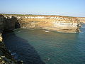
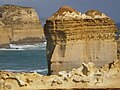
Furthermore, the Great Ocean Road runs in a north-westerly direction. This part of the coast is largely protected in Port Campbell National Park and is home to some of the most impressive coastal landscapes in the world. The coastal erosion by waves and rain has created some of the most famous rock formations here. The Twelve Apostles , Loch Ard Gorge with the collapsed Island Archway , The Grotto , the narrow cliff Razorback and London Arch are the most famous. This stretch of coast is also called the Shipwreck Coast , as more than 80 ships have sunk here. Further to the northwest is the Bay of Islands Coastal Park with attractions such as the Bay of Islands and Bay of Martyrs and Massacre Bay, where violent incidents against the Aborigines have occurred in the past .
The rest of the Great Ocean Road is relatively unspectacular. It runs in the hinterland of the coast through smaller villages before it meets again at Allansford on the Princes Highway and ends.
tourism
In 1962, the government organization Tourist Development Authority declared the Great Ocean Road to be “one of the world's great scenic roads” (German: “one of the most beautiful roads in the world”).
In 2004 the Great Ocean Walk was opened, a hiking trail of 104 km in length that runs along the coastline close to the Great Ocean Road from Apollo Bay to the Twelve Apostles .
Every year since 2005 the Great Ocean Road Marathon takes place over 45 kilometers on a stretch between Lorne and Apollo Bay .
To meet tourist interest, eight major infrastructure projects worth AUD 480 million are planned on the coast of the Great Ocean Road , including an information center at Loch Ard Gorge , accommodation expansion, and road and road construction.
Environmental influences
On January 8, 1964, the road had to be closed because of a bush fire , as it had in 1962.
The coastline in the area of the Great Ocean Road has always changed its course due to the influences of nature, on the one hand due to processes of erosion and on the other hand due to the geological nature of the limestone there . In 1960 parts of the coast near Princetown were washed away by a storm. Land masses crashed on August 11, 1964, and 1971; Both times, sections of the road near Lorne had to be closed. In January 2011, overhanging cliffs crashed during heavy rain.
When the major floods in Victoria occurred in January 2011 , parts of the Great Ocean Road were also affected when land masses slide, so the road between Lorne and Apollo Bay was temporarily closed.
gallery

Lorne Harbor

Viewpoint at Cape Patton

Apollo Bay

Cape Otway with lighthouse

London Arch
View from The Razorback

The grotto

Twelve Apostles
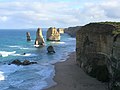
Twelve Apostles
The Razorback

Bay of Martyrs

Memorial on the Great Ocean Road


Web links
- Official tourism website
- Great Ocean Road tourism site (English)
- Official website of the Great Southern Touring Route
- Great Ocean Road and Environs (PDF; 402 kB)
Individual evidence
- ↑ a b standard.net.au : Mary Alexander: Multi-million dollar plan for Great Ocean Road coast , November 28, 2011, in English, accessed March 1, 2012
- ↑ environment.gov.au : Great Ocean Road, Victoria , in English, accessed October 4, 2011
- ↑ Richard Ewerist: The Complied Guide to the Great Ocean Road , S. 76/77. Tingleman 2009. ISBN 978-1-905864-26-3 Online on Googlebooks
- ↑ Spiegel-Online : Rock arch collapsed on the Great Ocean Road . Retrieved February 24, 2012
- ↑ in Australia: Details on the Great Ocean Road
- ^ Great Ocean Road in World Class . The Age. August 15, 1962. Retrieved February 24, 2012.
- ^ Great Ocean Walk . In: Visit Victoria . Tourism Victoria. Archived from the original on December 27, 2011. Info: The archive link was automatically inserted and not yet checked. Please check the original and archive link according to the instructions and then remove this notice. Retrieved February 24, 2011.
- ^ Dickens, Carl: Ocean Road to glory for marathon . Geelong Advertiser. May 17, 2010. Retrieved February 24, 2012.
- ↑ Washaways . The Age. April 23, 1960. Retrieved on February 24, 2012. ( Page no longer available , search in web archives ) Info: The link was automatically marked as defective. Please check the link according to the instructions and then remove this notice.
- ^ Landslide Closes Great Ocean Road . In: The Age . August 12, 1964. Retrieved February 24, 2012.
- ^ Ocean Road open - but watch out . The Age. December 9, 1971. Retrieved February 24, 2012.
- ↑ smh.com.au : Ewina Scott: Victoria braces for more evacuations , January 12, 2011, in English, accessed on February 28, 2012