
Twelve Apostles (Australia)
| Twelve Apostles | ||
|---|---|---|
 |
||
| Waters | Indian Ocean | |
| Geographical location | 38 ° 38 ′ S , 143 ° 3 ′ E | |
|
||
| Number of islands | 8th | |
| Main island | Piglet 1 | |
| Total land area | 0.005 km² | |
| Residents | uninhabited | |

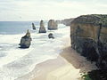
The Twelve Apostles ( German Twelve Apostles ) are limestone rocks up to 60 meters high in the sea . They are located between Princetown and Port Campbell in the Coastal Ward of the Corangamite Shire administrative district in the Australian state of Victoria in Port Campbell National Park . They are said to be the most photographed tourist attraction in Australia after Uluṟu (Ayers Rock) . Sunrise and sunset make the rocks shine in the surf. They are one of the highlights of the Great Ocean Road , a spectacular coastal road in southeast Australia, and the parallel Great Ocean Walk .
Surname
The Twelve Apostles were formerly called The Sow and Pigs (German: Die Sau und Schwein ; Pigs were often replaced by Piglets , i.e. pigs ) or Muttonbird Island , as noted on a map that Charles La Trobe made on his voyage of discovery in March 1864 used to Cape Otway . Muttonbird Island is in front of Loch Ard Gorge . It is believed that the current name Twelve Apostles came up in the 1950s, even though there were no twelve, but only nine rock pillars.
Rock formation
The pillar-like structures of different heights and diameters were created by the erosive force of the sea . Every year the cliffs of the Port Campbell Cliffs recede by around two centimeters. Peninsulas , which were later connected to the mainland only by means of natural bridges , were initially more resistant areas . As with the so-called London Arch in 1990 , these structures collapsed over time, and the rock towers of the Twelve Apostles are geologically only an appearance of short duration. The carbonate ground substance from the Heytesbury group was deposited in the Tertiary Miocene in the Otway basin after a sea level rise.
Despite its name, the formation consisted of only nine rocks. After a 50 m high rock (compare the two pictures from 2002 and 2012) collapsed at the base of the rock due to the natural erosion process on July 3, 2005, there were only eight rock pillars. In September 2009, another rock collapsed that was originally believed to belong to the Apostles. However, it turned out that the collapsed rock belonged to a sister formation.
The Twelve Apostles are part of a series of rock formations along this stretch of coast. Other attractions in the area include Pudding Basin Rock , Loch Ard Gorge , London Arch , The Razorback , the uninhabited Muttonbird Island , Thunder Cave , The Blowhole , Elephant Rock , Gibson steps , Bay of Islands , Bay of Martyrs , Bakers Oven and The Grotto .
The marine area where the Twelve Apostles are located is protected by the Twelve Apostles Marine National Park.
2002 before the collapse

2012 after the collapse (front left)


Web links
- TWELVE APOSTLES - Melbourne, Victoria, Australia official website
- Parks Victoria: Port Campbell National Park (English)
- Parks Victoria: Twelve Apostles Marine National Park (English)
- Image for a SPIEGEL online article, which documents the collapse of one of the rocks on July 3, 2005
Individual evidence
- ↑ Eric Bird: The Australian National Placename Survey (ANPS) - Place Names on the Coast of Victoria ( Memento of March 4, 2011 on WebCite ) - October 12, 2006, anps.org.au, English (PDF; 157 kB)
- ↑ Australian landmark disappears: “Twelve Apostles” rock collapses , n-tv.de on September 26, 2009
- ↑ brisbanetimes.com.au : Thomas Hunter: Sister, not apostle, crumbles into sea Thomas Hunter , September 28, 2009, accessed February 26, 2012