
Uluru
| Uluru (Ayers Rock) | ||
|---|---|---|
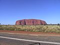
.jpg) The Uluru shines bright red in the light of the setting sun (view from the northwest) |
||
| height | 863 m | |
| location | Northern Territory , Australia | |
| Dominance | 29.3 km → Kata Tjuṯa | |
| Notch height | 340 m | |
| Coordinates | 25 ° 20 '43 " S , 131 ° 2' 5" E | |
|
||
| Type | Inselberg | |
| rock | Arkose , conglomerate | |
| Age of the rock | 550 million years (turn from the Neoproterozoic to the Cambrian ) | |
| particularities | • holy mountain of the indigenous people • important tourist attraction |
|
 The Uluru pale brown with a cloud-shrouded summit plateau (view from the northwest). |
||

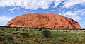
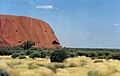
The Uluru ( Pitjantjatjara : Uluṟu ) [ ulu'ɹu ], English colonial name Ayers Rock , officially Uluru / Ayers Rock , is an island mountain in the central Australian desert , which rises approx. 350 m above its surrounding area.
Due to its spiritual relevance for the dreamtime stories , it is considered a sacred mountain by the local Aborigines , the Anangu . Because it attracts hundreds of thousands of visitors every year as one of Australia's most famous landmarks, there is a conflict of interest between Anangu and tourists in which the Aboriginal people enforced a ban on climbing the mountain from October 26, 2019.
The indigenous name Uluru was used exclusively by Aborigines until the 1990s. The English name Ayers Rock was common among Australians of European descent and outside of Australia (see history ).
geography
-crop.jpg)
The Uluru is about 3 km long, up to 2 km wide and has a circumference of about 9 km at the base. The summit is at an absolute height of 863 m . It rises 348 m above the dune landscape of Central Australia.
The Uluru is located in the Uluṟu-Kata-Tjuṯa National Park , near the place Yulara , about 340 km as the crow flies southwest of Alice Springs in the southwest of the Australian federal territory of the Northern Territory . The 1325 km² national park, in which the Uluru and the neighboring Kata Tju diea ("the Olgas") are located, is a UNESCO World Heritage Site .
The only paved road that leads to Uluru is the Lasseter Highway . This connects the mountain via the Stuart Highway with Alice Springs (470 km) and thus the rest of Australia. In addition, the Luritja Road branches off to Kings Canyon , which is also paved. At the Kata Tjuṯa, about 30 km west of Uluru as the crow flies, the Lasseter Highway turns into the Great Central Road , an unpaved outback track that leads to Laverton in central Western Australia . It is signposted there as “Docker River Road - to WA Border”. It is also possible to travel to Connellan Airport, which is about 10 km from Yulara .
geology
History of origin
Geological framework and prehistory

Uluru and Kata Tjuṯa are on the southern edge of the Amadeus Basin . Today's Amadeus Basin with Lake Amadeus , which extends over an area of 170,000 km², is the structural relic of a fossil, multi-folded sedimentary basin . This emerged about a billion years ago, in the early Neoproterozoic , as part of a larger sedimentary basin, the so-called Centralian Superbasin. The Amadeus sedimentary basin has a checkered history, during which it was mostly covered by the sea. For the first 200 million years or so of its existence, this Amadeus Sea was dominated by deposits of sand and silt . After that, the deposits of carbonate and evaporite rocks dominated . The evaporites ( gypsum and rock salt ) testify that the climate at that time was warm and dry and that the Amadeus Sea was cut off from the open ocean, so that large amounts of sea water could evaporate. Between about 700 and 600 million years ago the region was repeatedly covered by mighty glaciers , which is documented by moraine deposits . Then the earth's crust was compressed laterally in the region. This caused a folding of the sediments deposited up to then including the basement on which they were deposited . Mountain ranges formed and the region was raised above sea level. According to the Petermann Ranges southwest of Lake Amadeus, this event is known as the Petermann orogeny . The temporal proximity of the Petermann orogenesis to the Pan-African orogenesis (collision mountain formation in the course of the formation of the supercontinent Pannotia or Gondwana ) suggests that these events are related to one another.
Formation of the rock
At that time there was no "higher" life on the dry land on earth. The mountain landscape created in the course of the Petermann Orogeny was therefore not protected from erosion by a vegetation cover. Particularly in heavy rain, a lot of weathered debris was washed out of the mountains and deposited at the foot of the mountain ranges in the form of alluvial fans . The rocks that make up Uluru and Kata Tjuṯa date back to this alluvial fan sedimentation at the turn of the Neoproterozoic to the Cambrian , about 550 million years ago. The alluvial fans reached sediment thicknesses of at least 2500 m. Much later, the Uluru was formed from part of such an alluvial fan. This part was originally made up predominantly coarse-grained feldspar -containing sands . The layers from which the Kata Tjuṯa are built were even more coarse-grained and originally corresponded to a gravel sediment .
500 million years ago, at the turn of the Cambrian to the Ordovician , the mountains were largely eroded and the region sank again below sea level. The alluvial fan sediments were covered by sand, mud and dead marine animals. The load of these younger sediment layers and diagenetic cementation solidified the sands containing feldspar into an arkosis and the gravel into a conglomerate . These layers are now called Mutitjulu-Arkose or Mount Currie conglomerates .
400 to 300 million years ago, in the Devonian , the sea retreated again, because the earth's crust in the region was compressed again and therefore folded and lifted. This event is called the Alice Springs orogeny . The Mutitjulu Arkose and Mount Currie Conglomerates were also subjected to this folding.

Formation of the Inselberg
The sedimentation history of the Amadeus Basin ends with the Alice Springs orogeny. Since then, erosion has predominated over sedimentation in the region. It was not until 65 million years ago, at the turn of the Cretaceous to the Tertiary , that the region subsided again slightly, and a broad plain was created in which river and alluvial sediments accumulated. The warm and humid climate of this time allowed extensive swamp forests to flourish, which are now documented in the form of layers of coal .
The areas in which Uluru and Kata Tjuṯa are located today were located higher up and therefore still exposed to erosion, which ultimately resulted in the two rock massifs being carved out of the surrounding rock. The climate has become drier over the past 500,000 years, and the wind has laid a thin layer of sand over the entire area. At Uluru an area of the Mutitjulu arkosis is exposed today, which was straightened by 85 ° during the Alice Springs orogenesis. The layers are therefore almost perpendicular there. The conglomerates of the Kata Tjuṯa are only inclined by 15 to 20 ° to the horizontal. The strike direction of the strata at Uluru is northwest-southeast.
rock

The Uluru or the Mutitjulu arkose consists of arkose , a sedimentary rock similar to sandstone , which differs from "normal" sandstone but in that it has a high feldspar content, as well as conglomerates , i.e. H. from sedimentary rocks with grain sizes that are larger than those of a sandstone (these larger "grains" are called boulders ). The main part is coarse-grained arkosis and fine-grained conglomerate. Unweathered, the rock is greenish-gray. Exposed to weathering, the bound in some minerals hitherto iron to reddish to brownish is connections ( "rust") oxidized , which gives its typical color Uluru. The scaly surface of the rock is striking. It results from the chemical weathering of the feldspars. In addition, the extreme daily temperature fluctuations in the outback cause tensions in the rock. This creates cracks running parallel to the surface of the rock, along which larger clods peel off ( desquamation ).

The arkosis is composed of an average of 50% feldspar and 25–35% quartz grains . The remaining maximum 25% are rock fragments made of rhyolite or basalt . The feldspar fraction consists mainly of potassium feldspar and only a small part of plagioclase . It also contains orthopyroxes and sphene . The mineral grains and rock fragments are predominantly angular to rounded edges. A few well rounded quartz grains are interpreted as former basalt void fillings. The basalt fragments are rounded and always contain chlorite and epidote . The high proportion of potassium feldspar is explained by the close proximity of Uluru to the Musgrave Block . This basement massif, rich in granites and gneisses, begins only approx. 50 km south of Uluru and must have been largely involved in the building of the mountains at the time of the Mutitjulu-Arkose.
Sediment structures such as inclined, trough and ripple stratification as well as filled gullies (“scour-and-fill”) show deposits from fast flowing water. The occurrence of four types of facies (simplified: fine arcs, coarse arcs, fine conglomerates, coarse conglomerates) reflects four different energetic states of the alluvial fan. The fine-grained arkoses represent relatively leisurely rippling watercourses, the coarse conglomerates could be traced back to debris flows .
geomorphology
General
Uluru is often referred to as a " monolith ", especially in popular science and tourism literature. However, this is an ill-defined term that applies to a wide variety of compact structures with larger dimensions, natural as well as man-made. The value of “monolith” as a geomorphological term is therefore limited, which is why isolated, compact mountains should not be referred to as monoliths. The Uluru is the steeply erect Mutitjulu-Arkosen layer stack, which has been prepared from the surrounding area by erosion and which, according to estimates, reaches up to 6 km deep into the subsurface. Similar to the rock group of Kata Tjuṯa, it can be classified as an island mountain . Mutitjulu-arkose and the mount Currie conglomerates are, contrary to popular, highly simplified representations, not very likely, the two above ground digested ends of a single continuous layer, but represent separate fossil bed body. The sediment body of the Mutitjulu Arkose is about 2.4 km thick at Uluru. According to boreholes, its lateral extension does not seem to extend very far beyond the aboveground extent of Ayers Rock in the nearby subsurface. The Mount Conner ( "The forgotten Mountain"), a table mountain about 90 kilometers east of Uluru, also consists of sandstones. However, these are not arkotisch and also older than the Mutitjulu- arkose . They are assigned to the Winnall strata .
The Mount Gabi , a submarine mountain, which was discovered in 2006 off the southwest tip of Australia, respect has its shape and its dimensions, a certain resemblance to the Uluru, which is labeled "Uluru II" earned him in the Australian press. However, there are no further parallels between the two mountains.
Caves and other signs of weathering
In an area between 30 and 65 m above the foot of Uluru, especially on the south-eastern flank, there is a zone in which larger caves (also known as gaping mouth caves ) weather out of the rock. There are also caves and flared slopes at the foot of the mountain . The causes and mechanisms for the emergence of these phenomena are solution processes that were mediated by soil water (see → chemical weathering ). The caves and hollows marked areas of the rock that did not come to light during the creation of these structures, but were in contact with damp weathered debris (see → regolith , → detritus ). They were only exposed through the progressive erosive lowering of the surrounding area. These processes play a major role in the formation of the mountain, the steep slopes of which are therefore the result of the rock breaking over such caves and hollows, similar to a surf cliff . This hypothesis is supported by the preferred occurrence of caves and coves on the flank that is most south-facing, where, due to the shade, the upper soil layers can hold more water than at the foot of the other slopes.
In addition, a kind of weathering of holes occurs, which has formed a particularly large, extremely sharply outlined structure called The Brain on the north-eastern flank of the mountain, where the layer surfaces of the arcoses are exposed to a greater extent .
play of colors
Depending on the time of day and the weather, the Uluru (as well as the Kata Tjuṯa) appears in different shades, ranging from brown-gray to brown to orange and strong red, due to the different position of the sun, degree of cloudiness and correspondingly different amounts of the angle of incidence of light and the lighting intensity. In addition, haze or dust particles in the atmosphere influence the scattering of sunlight. Particularly when the sun is low, short-wave light cannot penetrate to the surface of the earth (see dawn or evening red), which means that the natural reddish color of the rocks at these times of the day is emphasized by the sunlight and the rocks appear bright red. If the rock gets wet from rain, the color also changes.
Dreamtime story

Aboriginal legends surround Uluru, telling the events of the dreamtime and trying to explain irregularities in the appearance of the rocks that are sacred to them.
This is how the Uluru myth describes the genesis of the landscape: On the sunny side of Uluru, the mala , the rabbit kangaroo people, and on the shadow side, the kunia , the carpet snake people, lived in harmony and peace. The remote Windulka invited the Mala to an initiation one, but the Mala called off because they wanted even perform initiations. But the Kunia gladly accepted and fell in love with the Sleepy Lizard Women (Lizard = blue-tongued pine cone lizard ) on their journey and did not travel any further. Thereupon they were punished by a Kulpunya , a dog with huge teeth and without hair, which was more vicious than a crocodile, but also the Mala were punished by the Liru , the poisonous snake people and other fighters who lived on Kata Tjuṯa . In the terrible battle with dead, seriously injured and fire, the earth trembled and Uluru rose from the then flat earth, and with that the spirit of Mala and Kunia turned to stone; the traces and the story of the fight can be read and told by the Anangu at Uluru.
There are rock carvings in several caves on Uluru that tell these and other legends. They have been renewed over and over again over the millennia.
history
The Anangu , an Aboriginal tribe, have lived in the area of the mountain for more than 10,000 years . In 1873 William Gosse discovered him as the first European on an expedition with Peter Warburton and named him after the then South Australian Prime Minister Henry Ayers Ayers Rock . Further expeditions followed with the aim of opening up the area for agriculture. However, they came to the conclusion that it was unsuitable for this. Prospectors , explorers and scientists then explored the area.
In 1920, parts of today's national park became a reserve for Aborigines.

The first tourists came to the Uluru area in 1936 and European settlement began in the 1940s. The first routes for cars and buses were created in 1948. In 1958 the area was declared a national park and named Ayers Rock - Mount Olga National Park . Eddie Connellan built a first motel and a landing strip northeast at the foot of Uluru after 1959 , which can still be seen in aerial photographs today (2017).
The Aboriginal Land Rights Act , signed by the Australian federal government on December 16, 1976, granted Aboriginal land rights in the Northern Territory. It came into force on January 26, 1977. The Anangu filed a land claim that was found to be legitimate at court hearings. On October 26, 1985, the Governor General Ninian Steven presented the title deed to the Anangu at a ceremony at the foot of Uluru. Then, minutes later, a contract was signed in which the Anangu leased the land back to the Australian Parks and Wildlife Service for 99 years . Since then, the board of directors of the national park has been composed equally of Anangu and whites.
In the early 1970s, the national park administration decided to close all tourist accommodations within the national park and to build new ones outside. For this purpose, 104 km² were made available beyond the northern border of the national park. There the artificial village of Yulara Resort was created with accommodations of all categories. In 1983 the campsite at the foot of Uluru was closed, in 1984 the old motel and the runway closed, and a new airfield opened north of Yulara. In 1992 the government of the Northern Territory sold the majority stake held up until then, and the Yulara Resort was renamed Ayers Rock Resort .
On December 15, 1993, after a decision by the Place Names Committee for the Northern Territory, the old name Uluru from the language of the Aboriginal tribe Pitjantjatjara was officially used for the first time next to the previously established colonial name Ayers Rock . On November 6, 2002, the Place Names Committee accepted a request from the Regional Tourism Association in Alice Springs and the name was officially changed to Uluru / Ayers Rock . The spelling with the slash follows the principles for dual naming of the Permanent Committee on Place Names (formerly Committee for Geographical Names in Australasia ) of the Intergovernmental Committee on Surveying and Mapping , an official Australian-New Zealand body for the standardization of maps and mapping / Land recordings. The signposts on the Lasseter Highway , however, are labeled Uluu (Ayers Rock) .
Also the Mount Olga now contributes again his Anangu names Kata Tjuta . Accordingly, Ayers Rock Mount Olga National Park is now called Uluṟu Kata Tjuṯa National Park . In common language, the name Ayers Rock is still in use, but its usage is decreasing.
tourism


Uluru can be hiked on a marked path, on which boards with explanations of the myth of the mountain are set up in significant places. The hike can be started from either the Mala or Kunija parking lot, or it can be reached on foot from the Cultural Center on the Liru Walk (4 km) to the Mala Walk . From the Mala parking lot, Uluru can be circled - usually clockwise: The path leads over the Mala Walk and Kantju Gorge (length: 2 km), Base Walk (length: 10.5 km), Kunija Walk (4 km) and Lungkata Walk (4 km). There are only two places on the trail where drinking water can be taken: at the Mala parking lot and at Kunjia Piti , where the Base Walk merges into the Kunjia Walk . It is strongly recommended that you bring your own water supplies. Two hikes on the Mala Walk , guided by park rangers, take place every day (October – April 8:00 am, May – September 10:00 am), starting at the Mala Walk sign .
There is a Cultural Center in the park run by the Anangu people. There they inform about the legend of the mountain, the dream time and the social rules of their tribe (Tjukurpa) . Traditional works of art and handicrafts are also exhibited, which can also be purchased.
Climbing Uluru was allowed until October 2019 on a marked route beginning at the western end of the mountain and equipped with a handrail, but was not wanted by the Anangu . They justified this with the fact that they fell into deep mourning when people had a fatal accident on the mountain, which they regarded as sacred, due to overexertion or a fall. There were 37 fatalities by the time the route was closed. For safety reasons, the ascent was previously closed from half an hour after sunset to half an hour before sunrise. In addition, the path could be temporarily blocked if
- rain or storm were predicted within the next three hours,
- the wind reached 25 knots at an altitude of 2500 feet (762 meters),
- extreme temperatures of 36 ° C and more were predicted or existed,
- the cloud line began below the summit,
- Rescue work was in progress,
- traditional Anangu ceremonies were held.
The number of tourists who climbed the mountain has recently declined thanks to the public relations work of the national park administration, and the board of directors hoped to be able to ban the ascent completely soon. On November 1, 2017, the national park administration finally announced that the ascent of Uluru would be prohibited from October 26, 2019, the 34th anniversary of the handover of the park to the Anangu in 1985. In fact, it was closed a day earlier, on October 25 at 4 p.m. local time.
In the Anangu faith, certain sites along the Uluru Base Walk tell or embody stories that are only allowed to be seen in this place and nowhere else. Therefore, photo and video recordings are prohibited at the following locations (starting at the Mala parking lot in a clockwise direction): Mala Punta , Warajuki , Tjutatkapi , Taputji , Kunjia Piti and Pulari . If you violate this rule, you risk high fines. According to the tribal laws of the Anangu, some places are also taboo for a gender or an age group , but this does not apply to tourists. There are also several sacred sites that are not open to tourists.
There are also Aboriginal rock carvings in the region . In the 1970s, tour guides often splashed the rock faces with water in order to increase the color contrast between the rock and the already relatively faded drawings so that they could be better seen in photos. As a result, some drawings were seriously affected. They can still be viewed, but fenced off with railings. In order to save them from destruction and to document the millennia-old cultural heritage, the Aborigines created a database . Access is in accordance with the tribal laws mentioned above, i.e. H. Areas that are taboo remain blocked for certain groups. There are year-round water holes in two places at the foot of the rock faces, which is a rarity in this arid region with an average of 270 mm of annual precipitation. They have a high status in the cult of the Aborigines.
The transport of sand and stones around Uluru, for example as a souvenir is not desired by the Anangu. According to their belief, everything must end where it began - if natural resources are removed, "the spirits cannot find rest". In the Cultural Center , letters from visitors are shown who have returned unauthorized natural produce out of repentance so that the Anangu could deposit them again at Uluru. Some report that their souvenirs brought them bad luck.
In the meantime, the ideas of the Aborigines have also influenced the nature conservation regulations of the national park. It is strictly forbidden to take material from the national park with you, to carry out scientific research or to describe or damage the rock faces. Violations can result in fines of up to AU $ 5,000, in extreme cases imprisonment.
Access to Uluru and other parts of the national park may be partially or completely closed to visitors during Anangu religious events.
There are two places where you can watch the sun rise or set, at the car sunset parking lot and at the Dune Lookout . In the latter, a view of both Uluru and Kata Tjuṯa is possible.
In the tourist settlement of Yulara , which is about 15 km away , there is a hotel complex and a camping site; overnight stays are not allowed in the national park itself.
Fields of Light
From April 1, 2016 to March 31, 2017, the British artist Bruce Munro presented an installation of 60,000 LED “tulips” at the foot of Uluru, which glow with varying colors at night. The electricity for this was supplied by batteries that were charged during the day via solar cells. The installation was called Tili Wiru Tjuta Nyakutjaku by the Anangu, the Aborigines who live in the area around the mountain , which means “looking at a lot of beautiful lights”. It is the latest in Munro's Fields of Light series .
gallery
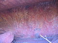
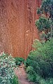
Rock art

Cave at the foot of the slope (see above )
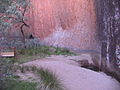
Water hole
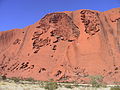
"The Brain", a particularly large weathering phenomenon on the northeast flank (see above )
Panorama of the northeast flank ("The Brain" on the far right in the picture)
View from the northwest (2003)

Panorama from the west, taken near the bottom of the Uluru Summit Walk
"Summit plate"

Panorama of the southwest flank
Smaller hollows and large "Gaping Mouth Cave" at the southern corner of the mountain, which, when shaded when the sun is high, look like black spots (see above )
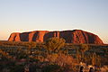
View from the southeast at sunrise (March 2010)
on the Uluru circuit
.JPG)
.JPG)
.JPG)
.JPG)

.JPG)


Web links
Individual evidence
- ↑ a b c d Peter-Matthias Gaede: Our earth. Countries, peoples, cultures. In: GEO topic dictionary. Volume 1, Brockhaus, Mannheim 2006, ISBN 3-7653-9421-1 , p. 145.
- ↑ Visitor guide at www.environment.gov.au (PDF; 4.9 MB), accessed on December 9, 2010.
- ↑ a b Christine J. Edgoose: The Amadeus Basin, central Australia. In: Episodes. Volume 35, No. 1, 2012, pp. 256-263, doi: 10.18814 / epiiugs / 2012 / v35i1 / 59912
- ↑ ARA Aitken, T. Raimondo, F. A. Capitanio: The intraplate character of supercontinent tectonics. In: Gondwana Research. Volume 24, No. 3–4, 2013, pp. 807–814, doi: 10.1016 / j.gr.2013.03.005
- ↑ a b c d e f g Uluru-Kata Tjuta National Park: Geology. Australian Government, Department of the Environment, accessed December 9, 2010.
- ↑ a b c d e f g David N. Young, N. Duncan, A. Camacho, PA Ferenczi, TLA Madigan: Ayers Rock, Northern Territory. (Second Edition). 1: 250 000 geological map series explanatory notes, SG 52-8. Northern Territory Geological Survey, Darwin 2002 ( PDF 3.1 MB)
- ^ IH Sweet: Uluru & Kata Tjuta: A Geological History. Australian Geological Survey Organization, Canberra 1992, ISBN 0-644-25681-8 .
- ↑ Robert P. Bourman, Clifford D. Ollier, Solomon Buckman: Inselbergs and monoliths: a comparative review of two iconic Australian landforms, Uluru (Ayers Rock) and Burringurrah (Mount Augustus). In: Journal of Geomorphology. Volume 59, No. 2, 2015, pp. 197-227, doi: 10.1127 / 0372-8854 / 2014/0148 , (alternative full-text access : ResearchGate ).
- ↑ a b C. R. Twidale: Uluru (Ayers Rock) and Kata Tjuta (The Olgas): Inselbergs of Central Australia. S. 321-332 in: Piotr Migon (Ed.): Geomorphological Landscapes of the World. Springer, 2010, ISBN 978-90-481-3055-9 .
- ↑ James Cowan, Dreamtime Revelations. The Aboriginal Spiritual Knowledge. Lüchow-Verlag, Stuttgart 2004, ISBN 3-363-03050-9 .
- ↑ a b c Uluru-Kata Tjuta National Park: 20th Anniversary "Handback" - a brief background. Australian Government, Department of the Environment, accessed November 16, 2012.
- ↑ Uluru-Kata Tjuta National Park: History of the park. Australian Government, Department of the Environment, accessed December 9, 2010.
- ↑ Dual naming. Policy page on the Place Names Committee for the Northern Territory website, accessed October 26, 2019
- ↑ Uluru / Ayers Rock. Datasheet in the Northern Territory Place Names Register, accessed October 26, 2019
- ^ Permanent Committee on Place Names: Principles for the Consistent Use of Place Names. Intergovernmental Committee on Surveying and Mapping, Canberra 2016 ( PDF 350 kB), Appendix B (p. 19)
- ↑ a b Famous rock in Australia: National park forbids climbing Uluru. ntv.de, October 25, 2019, accessed on October 25, 2019.
- ↑ Uluru-Kata Tjuta National Park Note - Please don't climb. Australian Government, Department of the Environment, accessed December 9, 2010.
- ^ Department of the Environment and Energy. Retrieved October 27, 2019 .
- ↑ Georgia Hitch, Nick Hose: Uluru climbs banned from October 2019 after unanimous board decision to 'close the playground'. In: ABC News. November 1, 2017, accessed November 1, 2017.
- ↑ Australia's Uluru can no longer be climbed. ORF.at news, November 1, 2017, accessed on November 1, 2017.
- ↑ Chelsea Heaney, Samantha Jonscher: Uluru climb closed permanently as hundreds of scale sacred site on final day. In: ABC News. October 25, 2019, accessed October 25, 2019.
- ↑ Andy Strummer: Stone Age on the Computer - The Cultural Heritage of the Aborigines. Radio documentary of the Bavarian Broadcasting Corporation, as of January 18, 2013.
- ↑ “Art that you feel.” Orf.at, April 4, 2016, accessed April 4, 2016.
- ↑ Brigid Delaney: 'Seeing Uluru changed my life': Bruce Munro's lightbulb moment. In: The Guardian. March 31, 2016, accessed April 4, 2016.