Kata Tjuṯa
| Kata Tjuṯa | ||
|---|---|---|
|
Kata Tjuṯa |
||
| height | 1069 m | |
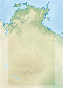
| location | Northern Territory , Australia | |
| Coordinates | 25 ° 17 '57 " S , 130 ° 45' 29" O | |
|
|
||
| Age of the rock | approx. 500 million years | |
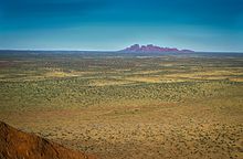
The Kata Tjuṯa (the Olgas ) are a group of 36 mountains in central Australia about 51 kilometers from the town of Yulara . Together with Uluṟu (Ayers Rock), 30 kilometers away , they are surrounded by the Uluṟu-Kata-Tjuṯa National Park . The highest rock at 1069 meters, Mount Olga , protrudes 564 meters from the area.
Name and discovery history
The Kata Tjuṯa were named The Olgas on October 21, 1872 by their discoverer, the Australian Ernest Giles from England . Ernest Giles, who was on the way to Lake Amadeus , felt obliged to his supporters, the Württemberg royal house with King Karl and his wife, Queen Olga of Württemberg .
The name Mount Olga was officially changed to Mount Olga / Kata Tjuta on December 15, 1993 , and on November 6, 2002 it was designated as Kata Tjuta / Mount Olga by the local Tourism Association in Alice Springs .
The Kata Tjuṯa were noted as Kartuta and Cutta Toota in early Australian maps. Kata Tjuṯa comes from the Aboriginal language of the Anangu tribe : Kata stands for head and Tjuta for many; consequently the name means many heads , which describes the mountain well.
geology
The Kata Tjuṯa originated around 550 million years ago at the same time as the Uluṟu . The Kata Tjuṯa are part of an underground rock layer that was formed in erosion processes in a sedimentary basin , the Amadeus Basin .
The mountain tops are on the southern edge of the Amadeus Basin, which was formed about 900 million years ago. Layers of sediment were deposited in this basin over hundreds of millions of years. After about 300 million years, this process ended and a shallow lake was formed. This dried up, leaving behind crusts of salt. This was followed by a cold period in which the older sediments of the Amadeus Basin were folded and bent. The land was pushed up and mountains formed. The mountain landscape was subject to the processes of erosion , and large masses of alluvial land were deposited at the foot of the mountains. Both the Uluṟu and the Kata Tjuṯa are the product of these deposition processes and originated at the same time around 550 million years ago.
500 million years ago, a shallow lake again covered this area, in which sediments were deposited. These pressed and cemented the coarse gravel of the Kata Tjuṯa into conglomerate . Another folding took place, which rose above the lake level and triggered the mountain formation of Alice Springs , the layer of the Kata Tjuta conglomerate was positioned 15 to 20 ° from the horizontal. 65 million years ago a wide valley was formed between Uluṟu and Kata Tjuṯa, this was filled with river sands and coal deposits. During this period there was a rainy climate and over the past 500,000 years the climate has become drier and a thin carpet of sand has covered the layers of sediment.
Tourist information
The Kata Tjuṯa are owned by the Anangu . Since, according to their mythology, the Kata Tjuṯa are connected with the dream time , the Anangu use them as a place for rituals. For this reason, tourist access is restricted.
A hiking trail in the Valley of the Winds is open to the public and takes three to five hours, depending on the walking pace. However, this path is closed on hot days from 36 ° C to protect visitors. There are two viewpoints on the hiking trail and drinking water only at one point, so it is recommended that you bring enough drinking water with you.
Another short hiking trail leads from the visitor parking lot as a dead end into a cut, the Walpa Gorge , between two “heads”; the way there and back takes about 1 hour.
There are no camping facilities at the visitor parking spaces. Visitors have to leave the site in the evening. From the Kata Tjuta Dune Viewing Area you can view Kata Tjuṯa at sunrise and sunset. The reflection of the sunlight causes the mountains to appear gray to brown or red in color, this also depends on the position of the sun and the composition of the atmosphere (haze, dust particles, etc.).
The Kata Tjuṯa can be reached by vehicle on the paved Lasseter Highway , which branches off from the Stuart Highway and also runs past Uluṟu.
Web links
Individual evidence
- ↑ Place Names Register Extract: Kata Tjuta / Mount Olga on NT names Register. Information on ntlis.nt.gov.au . Retrieved December 11, 2010
- ↑ Geology of Uluru on www.environment.gov.au ( Memento of the original from October 28, 2007 in the Internet Archive ) Info: The archive link has been inserted automatically and has not yet been checked. Please check the original and archive link according to the instructions and then remove this notice. . Retrieved December 9, 2010
- ↑ Visitor information for the Uluru – Kata Tjuta National Park (PDF; 4.9 MB). Retrieved December 11, 2010
- ↑ Geology of Uluru at www.environment.gov.au . Retrieved May 1, 2016


