Cape Otway
| Cape Otway | ||
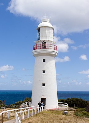
 Lighthouse on Cape Otway |
||
| Geographical location | ||
|
|
||
| Coordinates | 38 ° 51 '16 " S , 143 ° 30' 42" O | |
| Waters 1 | Bass Street | |
Cape Otway is a cape in the south of the Australian state of Victoria .
Much of the area is part of the Great Otway National Park . The headland is accessible via a 14-kilometer paved spur road from the Great Ocean Road or via the Great Ocean Walk .
history
The area around the cape was originally settled by the Gadubanud Aboriginal people . Archaeological sites, so-called shell middens , testify to their deposits. The cape was discovered when Lieutenant James Grant was exploring the coast of Victoria aboard the Lady Nelson . The government decided that the headland should serve as a location for a lighthouse . The hard-to-reach site was eventually reached by land, and construction of the Cape Otway Lighthouse began in 1846. It was built from natural stones taken from the nearby Parker River without cement or mortar .
The lighthouse, commissioned in 1848, was the second built in Australia and the longest-running lighthouse on mainland Australia. In 1850 the first weather station was put into operation; Even today the place is a weather observation point. A telegraph station was added when Tasmania was connected to the mainland in 1859 by a telegraph cable that ran from Cape Otway to Launceston . Part of the cape has been opened to settlers.
In 1942, American troops built a radar bunker on the Cape. Like the lighthouse, it can be visited.
The beacon was decommissioned in January 1994 and replaced by a solar-powered lamp at the foot of the lighthouse.
Shipping disasters
For many nineteenth-century ship crews, Cape Otway Lighthouse was the first landmark they saw after traveling more than 15,000 kilometers around Africa and through the Indian Ocean. Eight ships were wrecked on the cliffs of Cape Otway:
- Marie (1851)
- Sacremento (1853)
- Shomberg (1856)
- Loch Ard (1878)
- Joseph H. Scammell (May 1891)
- Fiji (September 1891)
- Casino (1932)
- City of Rayville (November 8, 1940)
The City of Rayville was the first American ship to be sunk as a result of German acts of war in World War II . At this point in time the USA was not yet at war with the German Reich. A German mine ship, the Passat , mined the Bass Strait at the end of October 1940 . The mine explosion was noticed from the lighthouse. Ships in nearby Apollo Bay ran out and brought the crew, who had fled in lifeboats, to safety. With the exception of one man who wanted to hide personal belongings below deck and was torn down with the ship in the process, all crew members were rescued.


