
Beauly Firth

The Beauly Firth is a bay at the head of the Moray Firth in the Scottish Council Area Highland . It extends about 11 km in an east-west direction into the country and has a maximum width of about 3 km. At her head is the city of Beauly while Inverness is at the beginning of the bay.
At Beauly the same river flows Beauly from the west into the Beauly Firth. The Ness , which flows into Inverness, forms another inlet . The Caledonian Canal also ends in Inverness in the Beauly Firth. The Black Isle peninsula forms the north shore of the bay. Opposite Inverness there is North Kessock, the only other significant river bank settlement. The Kessock Bridge , built between 1976 and 1982, connects the two places. With the trunk road A9 it leads one of the most important traffic routes in the Highlands . Previously there was a ferry connection at this point.

View from the north bank of the Beauly Firth
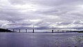
Kessock Bridge


Web links
Individual evidence
- ↑ Beauly Firth. In: David Munro, Bruce Gittings: Scotland. An Encyclopedia of Places & Landscapes. Collins et al., Glasgow 2006, ISBN 0-00-472466-6 .
- ↑ Kessock Bridge. In: David Munro, Bruce Gittings: Scotland. An Encyclopedia of Places & Landscapes. Collins et al., Glasgow 2006, ISBN 0-00-472466-6 .
- ↑ Kessock. In: Francis H. Groome: Ordnance Gazetteer of Scotland: A Survey of Scottish Topography, Statistical, Biographical and Historical. Volume 4: (Har - Lib). Thomas C. Jack, Grange Publishing Works, Edinburgh et al. 1885, p. 353.
Coordinates: 57 ° 30 ′ N , 4 ° 20 ′ W