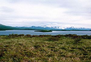
Becharof Lake
| Becharof Lake | ||
|---|---|---|

|
||
| Geographical location | Lake and Peninsula Borough in Alaska (USA) | |
| Tributaries | Becharof Creek | |
| Drain | Egegik River | |
| Location close to the shore | Egegik | |
| Data | ||
| Coordinates | 57 ° 56 ′ N , 156 ° 25 ′ W | |
|
|
||
| Altitude above sea level | 4 m | |
| surface | 1 170 km² | |
| length | 60 km | |
| width | 24 km | |
| Maximum depth | 180 m | |

|
||
| Satellite image of Becharof Lake | ||
The Becharof Lake or Becharofsee is a 60 km long and 24 km wide lake on the Alaska Peninsula in the US state of Alaska .
With an area of 1170 km², it is the second largest lake in Alaska after Iliamna Lake . It is located 37 km southwest of the city of Egegik and is located in the Becharof National Wildlife Refuge . The lake is drained by the Egegik River westwards to Bristol Bay .
The lake was named in 1868 by the naturalist William Healey Dall after the Russian navigator Dmitri Botscharow , who explored Alaska in 1788.
Web links
Commons : Becharof Lake - collection of images, videos and audio files
- Becharof National Wildlife Refuge (English)
