Bedburg West
Bedburg-West is part of Bedburg in the Rhein-Erft-Kreis in North Rhine-Westphalia . It is the resettlement place for the inhabitants of some smaller villages in the city of Bedburg, who settled there from the 1960s.
geography
It is located west of the city center, hence the name Bedburg-West. In the north lies Lipp (Bedburg) , in the west Kirchtroisdorf , in the south Kirdorf and in the east Bedburg and Blerichen .
history
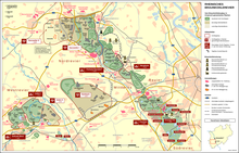
Preparations for relocating Geddenberg , Muchhaus and Oberschlag due to the opencast mine began in the mid-1960s. In 1969 these towns had to be cleared. It was decided to move to Bedburg-West, close to the train station and the city center. In the 1970s, Blerichen (East) and Winkelheim were relocated to Bedburg-West. In 1977 this relocation phase was completed. In 1982 the last town in Bedburg-West was brought in, Buchholz (Bedburg) . The relocation was completed in 1983.
Overall, the residents of Geddenberg, Muchhaus, Tollhausen (Bedburg) , Oberschlag, Blerichen (East), Winkelheim, and Buchholz (Bedburg) found their new home in Bedburg-West .
Worth seeing
In the center of the district is the Sankt Antonius Chapel, which is reminiscent of its predecessor in Altbuchholz. The church stands in the middle of a green area where, in addition to a village fountain, there are also old war memorials . The chapel is no longer used for masses.
Facilities
In Bedburg-West there is a Catholic and Protestant kindergarten and an old people's home.
Web links
Individual evidence
- ↑ Proof of the name (official city page ) ( page no longer available , search in web archives ) Info: The link was automatically marked as defective. Please check the link according to the instructions and then remove this notice.
- ↑ http://www.strassenkatalog.de/panoramio/Kreuz_an_der_St_Antonius-Kapelle_Bedburg-West,40540748.html
- Resettlement dates on a memorial plaque in the district
Coordinates: 50 ° 59 ' N , 6 ° 34' E

