Bengkulu (city)
| Bengkulu | |
|---|---|

|
|
| Basic data | |
| State : | Indonesia |
| Province : | Bengkulu |
| Coordinates : | 3 ° 48 ′ S , 102 ° 16 ′ E |
| Area : | 144.5 km² |
| Residents : | 340,000 (2007) |
| Population density : | 2,352.9 inhabitants / km² |
| Official Website: | www.bengkulukota.go.id |
| politics | |
| mayor | Ahmad Kanedi |
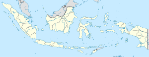
Bengkulu on the map of Indonesia |
Bengkulu is a city on the southwest coast of Sumatra , Indonesia and the capital of the Bengkulu Province of the same name . Until the 1970s, the place was considered one of the most remote places in Indonesia. In the absence of roads, it could only be reached by coastal ships. Ships go from the port to the island of Enggano .
In 2007 the city had 340,000 inhabitants on 144.5 km². Today it has an airport .
history
At the end of the 13th century, the region came under the rule of the Hindu Empire Majapahit . The British East India Company established a trading post in Bengkulu called Bengcoolen in 1685 after being driven out of Bantam on the island of Java in 1682 . In 1824 the British exchanged the colony for Malacca for the Dutch.
From 1938 to 1941, Bengkulu was designated by the Dutch-East Indian colonial administration as the place of exile for Indonesia's future first President Sukarno .
Web links
Individual evidence
- ^ Edmund Roberts: Embassy to the Eastern Courts of Cochin-China, Siam, and Muscat . Harper & Brothers, New York 1837, p. 34.
