
Hawiyyat Nadschm
| Hawiyyat Nadschm | ||
|---|---|---|

|
||
| Hawiyyat Nadschm (Bimmah Sinkhole) | ||
| Geographical location | Coast of the Gulf of Oman on the Eastern Hajar Mountains | |
| Tributaries | Connection to the sea via cave systems | |
| Location close to the shore | Dibab , Bimma | |
| Data | ||
| Coordinates | 23 ° 2 '10 " N , 59 ° 4' 19" E | |
|
||
| Altitude above sea level | 20 m | |
| Maximum depth | approx. 60 m | |
|
particularities |
||

Hawiyyat Nadschm ( Arabic هوية نجم, DMG Hawiyyat Naǧm ), also called Bimmah Sinkhole , is a sinkhole on the northeast coast of the Sultanate of Oman . It has a diameter of about 40 meters and a depth to the water surface of about 20 meters.
location
Hawiyyat Nadschm is located on the northeast coast of the Gulf of Oman , about 500 meters from the coastline at the foot of the Hajar Mountains in the Wilāyat Quriat in Muscat Governorate . The sinkhole is about 120 kilometers from Muscat , on highway 17 halfway to Sur , near the village of Bimma . It is located in a fenced, park-like area, the Hawiyyat-Nadschm-Park, equipped with a public toilet and seating. Concrete stairs lead down to the clear, turquoise water. Bathing, snorkeling and diving in the sinkhole is permitted. Outside there are parking spaces, entry and parking is free.
Emergence
The nearby Gulf of Oman has over time eroded the coastal region below the Hajar Mountains and formed caves in the soft sandstone. The sinkhole was created by the collapse of the overburden. About 70 percent of the floor of the sinkhole is covered with water. The sinkhole is connected to the ocean via a cave system, the water in the sinkhole is therefore salty, but has a lower salinity than the nearby sea, as it mixes with groundwater. In about 10 meters water depth there is a brown-orange, about 2 meters thick thermocline with visibility less than one meter. Below the water is clear again. In the cave there is a guide line that marks the way. The open sea can be reached at a water depth of around 60 meters. Due to the great depth, this is only possible for trained cave divers . The upper areas can also be explored by well-trained recreational divers .
Legend
There is a legend that the sinkhole was created by the impact of a meteorite . The Arabic name Hawiyyat Nadschm translates as the shooting star . Alternatively, it is reported that the sinkhole was created by the impact of a piece of the moon. The Arabic alternative name Bait al Afreet means house of demons .
gallery
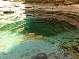
View of and below the water surface in the sinkhole

Sign with history on the sinkhole

Sinkhole with the Hajar Mountains in the background


