Birim
| Birim | ||
|
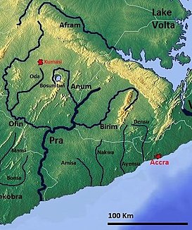
South Ghana with the Birm |
||
| Data | ||
| location |
|
|
| River system | Pre | |
| Drain over | Pra → Gulf of Guinea | |
| muzzle | west of Akim Oda in the Pra coordinates: 5 ° 58 ′ 26 " N , 1 ° 13 ′ 18" W 5 ° 58 ′ 26 " N , 1 ° 13 ′ 18" W |
|
| Mouth height |
101 m
|
|
| Discharge at Akim Oda A Eo gauge : 3247 km² Location: 60 km above the mouth |
MQ Mq |
15 m³ / s 4.6 l / (s km²) |
The Birim is a river in Ghana and a tributary of the Pra .
course
The river has its source in the hills of the Atewa Range and flows through the Eastern Region of Ghana. Together with the other tributaries of the Pra, the Birim is part of the second largest drainage system in Ghana.
raw materials
Due to the mining of raw materials in the area through which the Birim flows, the river is heavily polluted by the by-products of raw material extraction. The Birim is located in the main mining area for diamond mining. In the Akwatia mine , for example, 2,000,000 carats of diamonds are mined every year.
spirituality
The Akim believe that the river provides the spiritual nourishment of the people. It is forbidden to swim or fish in it on Tuesdays.
