Pra (Ghana)
| Pre | ||
|
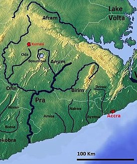
Southern Ghana with the Pra |
||
| Data | ||
| location |
|
|
| River system | Pre | |
| muzzle | At Shama in the Atlantic Coordinates: 5 ° 1 ′ 9 ″ N , 1 ° 37 ′ 34 ″ W 5 ° 1 ′ 9 ″ N , 1 ° 37 ′ 34 ″ W |
|
| Mouth height |
0 m
|
|
| length | 240 km | |
| Catchment area | 23,200 km² | |
| Discharge at the Daboasi gauge (1526300) A Eo : 22,714 km² Location: 56 km above the mouth |
NNQ (min. Month Ø) MNQ 1965–1978 MQ 1965–1978 Mq 1965–1978 MHQ 1965–1978 HHQ (max. Month Ø) |
5 m³ / s 40 m³ / s 197 m³ / s 8.7 l / (s km²) 388 m³ / s 1401 m³ / s |
| Left tributaries | Birim | |
| Right tributaries | Anum , Offin | |
| Residents in the catchment area | 4,180,387 (2000 Census) | |
The Pra is a river in Ghana .
course
In its first third it forms the border between the Ashanti Region and the Eastern Region , then flows through the Central Region and finally flows into the Atlantic Ocean east of Sekondi-Takoradi in the Western Region . Together with its tributaries Anum , Offin and Birim , the Pra forms the second largest drainage system in Ghana after the Volta with its tributaries. The Pra mainly drains the region's ever-humid rainforests . Depending on the source, its catchment area is stated to be between 23,200 and 22,100 km².
The Pra flows into the Atlantic near Shama and, despite its size, is not widely navigable. On the entire route, with the exception of the estuary, the Pra is a river full of rapids (e.g. the Bosomasi Rapids). In Twi-Praso it crosses the now disused railway line from Accra to Sekondi , so that the Pra had to be spanned with a railway bridge. The mouth of the Pra in Shama has been developed into an important fishing port for the city and the region.
Hydrometry
Average monthly flow of the Pra measured at the hydrological station at Daboasi in m³ / s.

raw materials
The catchment area is rich in natural resources. The AngloGold Ashanti mine in Obuasi is one of the largest in Africa. Gold is also mined at Konongo and Offin in Dunkwa . In addition, 2,000,000 carats of diamonds are mined each year in Akwatia in the Birim catchment area.
history
In the 19th century the Pra formed the border between the Ashanti Empire ( Ashanti Confederacy ) and the Gold Coast crown colony .
