
Birkel Cave
| Birkel Cave
|
||
|---|---|---|
 Entrance to the Birkel Cave |
||
| Location: | Swabian Alb , Baden-Württemberg , Germany | |
| Height : | 580 m above sea level NN | |
|
Geographic location: |
48 ° 41 '25 " N , 10 ° 11' 47" E | |
|
||
| Cadastral number: | 7327/01 | |
| Geology: | Upper Jurassic | |
| Type: | Crevice cave | |
| Lighting: | No | |
| Overall length: | 51 meters | |
| Particularities: | Keyhole profile | |

The Birkel Cave is a 51 meter long crevasse cave that runs horizontally into the Jura rock there . The cave entrance is located around 2.5 kilometers east of Heidenheim an der Brenz in the Buchschorren forest, not far from the Bohner ore mines . The cave has a profile in the form of a keyhole and is safe to enter.
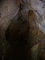
Inside the Birkel Cave

Web links
Commons : Birkelhöhle - Collection of images, videos and audio files
- Hiking route to the Birkel cave (Tour 2, Schmittenberg circular routes) , website of the city of Heidenheim
- Birkel cave in the Buchschorren NE forest area of Heidenheim an der Brenz , geotope profile from the State Office for Geology, Raw Materials and Mining (PDF)
- Geotopes in the Stuttgart administrative region - 6-4 LK Heidenheim (p. 117, picture p. 118)
literature
Hans Binder , Herbert Jantschke: Cave guide Swabian Alb. Caves - springs - waterfalls . 7th completely revised edition. DRW-Verlag, Leinfelden-Echterdingen 2003, ISBN 3-87181-485-7 , p. 80 .
Individual evidence
- ↑ Hans Binder, Herbert Jantschke: Höhlenführer Schwäbische Alb. Caves - springs - waterfalls , p. 80.