Bishop's Island (Clare)
| Bishop's Island | ||
|---|---|---|
| Bishop's Island | ||
| Waters | Atlantic Ocean | |
| Geographical location | 52 ° 40 '28 " N , 9 ° 41' 33" W | |
|
|
||
| length | 240 m | |
| width | 110 m | |
| surface | 2 ha | |
| Highest elevation | 65 m | |
|
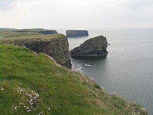
Cliff coast at Kilkee , with Bishop's Island in the background |
||
Bishop's Island ( Irish Oileán an Easpaig Ghortaigh ) is a small, steep rock island (a so-called stack ) 65 m high, about two kilometers west-southwest of Kilkee . Stacks are natural coastal areas separated from the mainland by processes of coastal geomorphology by wind and water. Bishop's Island is off the west coast of County Clare in Ireland . It lies below the Cliffs of Moher , 80-100 m from the cliff, opposite the Foohagh townland ( An Fhuathach ) and can only be reached by boat. The remains of a chapel ( oratory ) and a beehive hut ( Irish Clochán ) are attributed to a hermitage of St. Senan (d. 546). There are also two unadorned stone pillars ( English pillar ) on the island .


