Black Point (Livingston Island)
| Black Point | ||
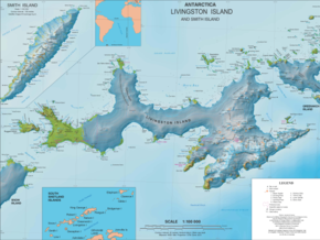
 Map of Livingston Island with the John Paul II Peninsula and Black Point |
||
| Geographical location | ||
|
|
||
| Coordinates | 62 ° 29 ′ S , 60 ° 43 ′ W | |
| location | Livingston Island , South Shetland Islands | |
| Waters | Drake Street | |
| Waters 2 | Spiller Cove | |
The Black Point ( English for Black Headland ) is a headland in the north of Livingston Island in the archipelago of the South Shetland Islands . It is located 4 km southeast of Cape Shirreff at the northern end of the John Paul II peninsula .
Scientists from the UK Discovery Investigations mapped the Cape from the RRS Discovery II in 1935 .
Web links
- Black Point in the Geographic Names Information System of the United States Geological Survey (English)
- Black Point on geographic.org (English)
