John Paul II Peninsula
| John Paul II Peninsula | ||
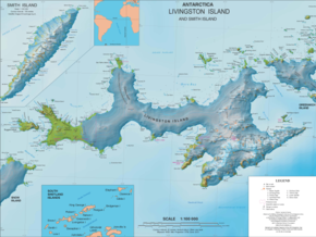
 Map of Livingston Island with the John Paul II Peninsula |
||
| Geographical location | ||
|
|
||
| Coordinates | 62 ° 31 '43 " S , 60 ° 45' 58" W | |
| Waters 1 | Drake Street | |
 View from Kuzman Knoll to the John Paul II peninsula |
||
The John Paul II Peninsula ( Bulgarian полуостров Йоан Павел II poluostrow Joan Pawel II ) is an icy peninsula in the north of Livingston Island in the archipelago of the South Shetland Islands . It is 12.8 km long, a maximum of 8.5 km wide and separates Hero Bay from Barclay Bay to the west . The Cape Shirreff is the northern end of the peninsula.
Bulgarian scientists named it on April 11, 2005 after Pope John Paul II (1920–2005), who had died nine days earlier, for his achievements in peace and international understanding.
Web links
- Ioannes Paulus II Peninsula. Information on the homepage of the Scientific Committee on Antarctic Research (SCAR ).
- Ivanov, L. General Geography and History of Livingston Island. In: Bulgarian Antarctic Research: A Synthesis . C. Pimpirev and N. Chipev (Eds.), St. Kliment Ohridski University Press, Sofia 2015. pp. 17-28. ISBN 978-954-07-3939-7
