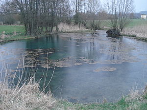
Bottomless hole
| Bottomless hole | |
|---|---|
 The bottomless hole |
|
| location | |
| Country or region | District of Ansbach , Middle Franconia ( Bavaria ) |
| Coordinates | 49 ° 17 ′ 14 " N , 10 ° 11 ′ 45" E |
| geology | |
| Mountains | Swiss franc amount |
| Source type | Karst spring |
| Exit type | Source pot |
| Hydrology | |
| River system | Rhine |
| Receiving waters | Östheimer Bach → Tauber → Main → Rhine → North Sea |
| Bulk | 70 l / s |
| depth | 6 m |
Coordinates: 49 ° 17 ′ 14 " N , 10 ° 11 ′ 45" E
The bottomless hole is a karst spring near Diebach in the Central Franconian district of Ansbach in Bavaria .
description
The bottomless hole is on the Frankenhöhe , southwest of Unteroestheim . It is a 15 m wide, bluish shimmering spring pot about 6 m deep. The gypsum karst spring , designated as a natural monument , pours out an average of between 60 and 80 liters per second. The flowing spring water flows over the Östheimer Bach to the Tauber .
Geotope
The bottomless hole has been identified by the Bavarian State Office for the Environment (LfU) as a geoscientifically valuable geotope (geotope number: 571Q002). It was also awarded the official seal of approval for Bavaria's most beautiful geotopes by the LfU .
See also
Individual evidence
- ↑ Bavarian State Office for the Environment, Geotop Gipskarstquelle "Bodenloses Loch" (accessed on November 26, 2017).
- ↑ Bavaria's most beautiful geotopes, gypsum karst spring Bodenlose Loch (accessed on November 26, 2017)