Bogong High Plains
| Bogong High Plains | ||
|---|---|---|
|
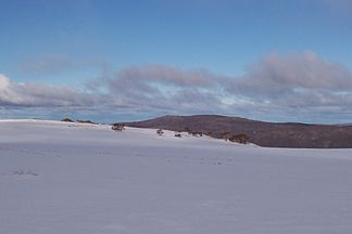
Typical winter scenery in the Bogong High Plains |
||
| Highest peak | Mount Bogong ( 1986 m ) | |
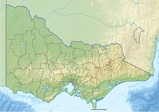
| location | Victoria , Australia | |
|
|
||
| Coordinates | 36 ° 56 ′ S , 147 ° 18 ′ E | |
The Bogong High Plains are a mountain range in the northeast of the Australian state of Victoria . They are located in the Alpine National Park south of Mount Bogong . The area belongs to the Great Dividing Range and is one of the largest snow-covered areas in the country in winter. It is easily accessible from the ski resorts at Mount Hotham and Falls Creek . The Bogong High Plains are very popular with mountain climbers in summer and ski tourists in winter.
In the winter months you can do all kinds of cross-country skiing and ski tours there . The Australian Alps Walking Track is used as a hiking trail in summer and as a cross-country ski run in winter. Mountain biking and cross-country hiking are common summer sports there.
history
The area was first explored by shepherds who looked for pastures, mostly for calves. The first major development program was the dam project on the Kiewa River . The necessary construction work began in the 1940s. Two reservoirs were created, the Pretty Valley Pondage and the Rocky Valley Reservoir . There were also a number of aqueducts that channel streams into the catchment area of the Kiewa River. The McKay Creek and the West Kiewa Power Stations supply most electrical energy. After the end of the hydropower project, tourism flourished, especially ski tourism in winter.
Scientific investigations
Systematic ecological studies began in 1947. Miss Maisie Fawcett (later Mrs SGM Carr ) created non-grazed areas to study the influence of pasture on the development of alpine and sub-alpine vegetation. These areas have been monitored continuously since then and provided the longest set of ecological data of any comparable project in Australia. A little later, the cattle pasture was banned at heights above 1,500 m. Finally, in 2005, the Victoria government banned cattle grazing across the area, in part based on the results of that trial.
The Bogong High Plains continue to be an important area for scientific research. In the summer, many scientists conduct studies in the area, e.g. B. in the areas of hydrology, changes in vegetation, sensitivity to fire, the introduction of weeds, the occurrence of native animals (e.g. Bergbilchbeutler ) and imported animals. There is also a component of the International Tundra Experiment (ITEX) in the area , which aims to highlight aspects of global climate change . An attempt is made to predict the future influence of higher temperatures.
Forest fires
Because of the large natural forest areas, the area is very vulnerable to forest fires. The major forest fires in 2003 have already destroyed a large part of the forest. Many well-known mountain huts were destroyed. The area was affected again in the 2006/2007 forest fire season, but the damage was limited due to favorable weather conditions.
Mountain huts
Mountain huts offer overnight accommodation for ski tourists in winter and hikers in summer. There are ten huts in the Bogong High Plains, each of them differently furnished and designed for different purposes. They were initially made by European pastoralists who emigrated to New South Wales in the 1830s . Today they are no longer used by pastoralists, but run by ski clubs. Some of them are not used and maintained on a regular basis.
The Wallace Hut is the oldest in the Bogong High Plains. It was built in 1889 and, like most huts, has been enlarged several times since then. It has no modern facilities and is not used for overnight stays. Their size is 4.5 m × 3.7 m.
The Bogong Rover Chalet was the first accommodation hut in the area and was built before the expansion of the winter sports areas in Australia. It was built in 1938 by the rangers and rovers of Victoria. It has the best facilities of any outside-resort cabin in Australia and is fully equipped to accommodate 35 people. It has been renewed and expanded since its construction. It uses solar energy , gas and wood heating and has its own electric generators. It is equipped with a full kitchen and showers. In winter it is available for the rangers and rovers and the '' Venturer Scouts '' for 13 weeks.
The Cope Cabin was built in 1929 by the Ski Club of Victoria .
The Fitzgerald cabin was one of the older cabins. In 1991 it burned down after being used by a school class and was rebuilt in 1993.
The Roper hut burned down in a forest fire in 2003 and was rebuilt in 2008.
The Wilkinson Lodge - called Wilky - was built by the State Electricity Commission of Victoria as a shelter for hydrological measurements before the construction of the Kiewa River dam project. The hut was later sold to a ski club, but without the land on which it was built. In 1962 they acquired members of the Melbourne Bushwalkers and donated them to their association. It was maintained by the association and served as a starting point for ski tours in winter. Throughout the year it was used extensively by other groups for scientific research or leisure activities. She survived the 2003 forest fires but burned down a year later, in January 2004, as a result of an accident in the kitchen when she was renting non-members. All that remains is a wooden crate. The National Parks Service , which manages the land, has not given permission to rebuild.
The Batty hut fell victim to a forest fire in 2006.
The Cleve Cole Hut on Mount Bogong was built in 1938 to commemorate Cleve Cole , who perished on a ski tour on Mount Bogong. Actually, Mount Bogong does not belong to the Bogong High Plains. Also on Mount Bogong are the Michell Hut on Eskdale Ridge, which was rebuilt in 2003 after a forest fire, and the Bivouac Hut on Staircase Ridge.
Other huts are the Tawonga Huts , the Young Hut , the Ryder Huts , the Cope Saddle Hut , the Pretty Valley Hut , the Edmondson Hut , the Johnston Hut , the Buckety Plains Hut , the Faithful Hut and Langford Gap Hut .
ecology
vegetation
The Bogong High Plains contain a mixture of different types of vegetation. About half of the area is covered with heathland, which covers some of the steeper and more sheltered locations. The earth's layer is generally thin and contains many stones. Around a quarter of the area is grassland, which occurs more in exposed locations and flat slopes because it is more resistant to wind and frost. The most fertile soil is found in the wetlands that cover about 10% of the Bogong High Plains. A wetland is defined as a location where there is waterlogging for at least one month per year. Waterlogging usually leads to soils with a high organic content, which results from the decay of plant material. The mineral content of these soils is rather low. Snow patch herb areas are found in places where snow remains for most of the summer. They are very rare in the Bogong High Plains.
summit
Mount Bogong, the highest mountain in Victoria, lies north of the Bogong High Plains and is separated from them by the valley of the Big River . Mount Feathertop is the outstanding peak in the western Bogong High Plains. Because of its proximity to Mount Hotham, it is popular as a hiking destination, but can also be reached from Harrietville .
| mountain | height |
| Mount Bogong | 1,986 m |
| Mount Feathertop | 1,922 m |
| Mount Nelse West | 1,893 m |
| Mount Nelse North | 1,885 m |
| Mount Fainter South | 1,883 m |
| Mount Hotham | 1,862 m |
| Mount McKay | 1,842 m |
| Mount Cope | 1,837 m |
| Spy Kopje | 1,837 m |
| Mount Jim | 1,818 m |
Web links
Individual evidence
- ^ Alpine National Park . Parks Victoria .. Found January 21, 2007 ( Memento of July 6, 2011 in the Internet Archive )
- ^ A b The Cow Paddock - a report to Parks Victoria . Found June 5, 2007
- ↑ Alpine plants put to global warming test, The Age, June 14, 2004., Found September 12, 2007
- ↑ Wallace's hat . Kosciusko Huts Association. Found January 21, 2007 ( Memento of the original from May 5, 2007 in the Internet Archive ) Info: The archive link was inserted automatically and has not yet been checked. Please check the original and archive link according to the instructions and then remove this notice.
- ↑ Bogong Rover Chalet . Found on March 18, 2012
- ↑ The High Country, walks around Bogong High Plains and Mountain Creek . Alpine National Park. Found on April 6, 2010 ( Memento of the original from March 28, 2011 in the Internet Archive ) Info: The archive link was inserted automatically and has not yet been checked. Please check the original and archive link according to the instructions and then remove this notice.
- ↑ Mount Feathertop . Remote Tech '. Found on August 22, 2007 ( memento of the original from August 29, 2007 in the Internet Archive ) Info: The archive link was inserted automatically and has not yet been checked. Please check the original and archive link according to the instructions and then remove this notice.
- ↑ Victoria Alps . Peakbagger.com. Found August 3, 2011


