Great dividing range
| Great dividing range | ||
|---|---|---|
|
Great dividing range |
||
| Highest peak | Mount Kosciuszko ( 2228 m ) | |
| location | Australia to Tasmania | |
|
|
||
| Coordinates | 36 ° 27 ′ S , 148 ° 16 ′ E | |
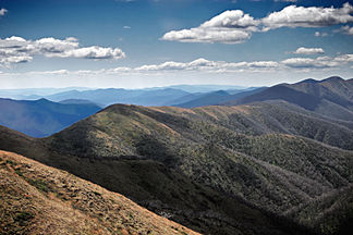
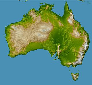
The Great Dividing Range (also short: Great Divide ; also: Eastern Highlands ; German also: Australian Bergland , Great Australian Separation Mountains or Australian Cordillera ) is Australia 's largest mountain range . It divides the east coast from the inland and has a great influence on Australia's climate.
The Great Dividing Range extends from the northeastern tip of Queensland along the entire east coast through New South Wales to Victoria , where it takes a westerly direction and finally to the west of the state at the last foothills of the Grampian Mountains in the vast Australian central plains on the continent Australia loses. The Great Divide continues into Tasmania , where it branches in two directions.
description
All high mountain areas including the highest mountain on the Australian mainland, Mount Kosciuszko ( 2228 m ), belong to the Great Dividing Range. Their highest sections - in southern New South Wales and eastern Victoria - are known as the Australian Alps .
The name Great Dividing Range (in German: "Großes Scheide-Gebirge") is actually only partially applicable, as the range does not represent a uniform mountain range. However, it is actually a watershed between the rivers on Australia's east coast, which flow directly into the Pacific Ocean , and those of the Murray-Darling Basin , which flow away from the coast into the inland plains.
In some areas such as the Blue Mountains , the Snowy Mountains , the Victorian Alps and the eastern terrain of the New England region, the Great Dividing Range is a clear barrier. In other regions, the mountain slopes are gentler and in some places the mountains are hardly noticeable as such . Although some peaks in the high mountain regions reach considerable heights of just over 2,000 m by Australian standards, the mountains are not very steep due to their old age and the erosion that has taken place . So practically all peaks can be climbed without mountain equipment.
Much of the Great Dividing Range is taken up by national parks and other nature reserves . In the lower elevations, wood is felled, which nature conservationists strongly criticize. In addition, practically all of the water used in Eastern Australia is obtained from the mountains; there are some reservoirs.
history
The Great Dividing Range was in the Carboniferous arched about 300 million years ago, when continental plates collided, the part of today South Africa and New Zealand are. Subsequently the mountains were subject to severe erosion .
Prior to European colonization, Aborigines lived in this area, which they were displaced after they overcame the Blue Mountains . This was first achieved in 1813 by Gregory Blaxland , William Lawson and William Charles Wentworth , who came to the Bathurst area . Blaxland was then commissioned by Governor Lachlan Macquarie to build a road into the area and found the city of Bathurst. The mountains were later developed by roads to Goulburn in the southwest and as far as Newcastle .
Explorers such as Allan Cunningham , John Oxley , Hamilton Hume , Paul Edmund Strzelecki , Ludwig Leichhardt and Thomas Livingstone Mitchell penetrated the mountains . Through their voyages of discovery, agricultural area became known, which settlers followed in the 1830s. Were opened Gippsland and Riverina in the south to the Liverpool Plains and the Darling Downs to the north. From the 1860s on, railway routes and other roads were built through the mountains. Nevertheless, regions of the mountain range remained partially untouched and, for example, only one road ran through eastern Victoria from north to south.
Water catchment area

The mountain range is an important water catchment area for Australia, especially for Queensland.
In some valleys there are dams that are of great importance for the production of drinking water and for the generation of electrical energy, such as the Upper Nepean Scheme , the Snowy Mountains System and the Warragamba Dam . The Bradfield System , for example, transports water from the forests to the Queensland coast.
Many of the rivers flow west of the range such as the Condamine River , Flinders River , Herbert River , Lachlan River , Macintyre River, and Namoi River . Rivers flowing north of the Murray-Darling Basin are Goulburn River , Mitta Mitta River , Kiewa River , Ovens River , King River , Loddon River, and Campaspe River . The Brisbane River , Burdekin River , Clarence River , Hastings River , Hawkesbury River , Hunter River , Macdonald River , Macleay River , Mary River , Richmond River , Shoalhaven River and Snowy River flow east into the Pacific . The Snowy River, Cann River , Tambo River , Mitchell River , Latrobe River , Thomson River , Yarra River , Werribee River , Hopkins River and Glenelg River flow into the southern ocean .
Railways
Railroad lines were built in Australia's early years through the Great Dividing Ranges, which continue to operate to this day:
- Railway line from Ipswich - Toowoomba (1867)
- Main North railway line , from Newcastle to Tamworth (around 1870) - summit in the Ardglen Tunnel
- Main Western railway line , from Sydney to Lithgow (1869) over the Blue Mountains
- Main Southern railway line , from Sydney to Goulburn (1869)
- North East railway line , from Melbourne to Seymour (1872)
- Bendigo railway line , from Melbourne to Bendigo (1862)
- Serviceton railway line , from Melbourne to Ararat (1875) via Ballarat
Streets
The mountain range is crossed by numerous Australian highways such as the Alpine Way , Great Alpine Road , Hume Highway , Great Western Highway , Capricorn Highway , Cunningham Highway , New England Highway , Oxley Highway , Warrego Highway , Waterfall Way , Thunderbolts Way , Calder Highway , Western Highway and Murray Valley Highway .
Nature reserves
In the mountains there are numerous national parks and other nature reserves, for example (VIC = Victoria , NSW = New South Wales, QLD = Queensland , ACT = Australian Capital Territory ):
Mountain ranges
In the Great Dividing Range there are numerous individual mountains or mountain ranges, mountainous regions and high plateaus.
Queensland
The northernmost areas in Queensland of the Dividing Range in Queensland are Richard Range, Sir William Thompson Range, and McIlwraith Range . Further west are the Wilkinson Range, Kirchner Range, Granite Hills, Gregory Range and Newcastle Range. To the south are the Forsyth Range and to the west of it the Allan's Range, Cory's Range, Tully Range, Kangaroo Mountains, Sword Range, Charters Range, Lawson's Hills, Hill's Range, Muller Range, Finucane Range, Standish Range and the Little Range (Longsight Peak) . To the east are the Granite Range and Seventy-Mile Range and further south the Terraic Range.
New South Wales
A line from Maryland to a point at Tenterfield defines the boundaries between Queensland and New South Wales. From Tenterfield the mountains lead into the New England Range and further west into the Liverpool Range to Cassilis and from there to Goulburn . From Goulburn it extends into the southern and northern Tableland, into the Main Range and Blue Mountain Range and becomes the Cullarin Range and from Nimitybelle to the Gourock Range. At Nimitybelle it turns northwest to Kiandra in the Monaro Range. From Kiandra the mountain range is called Muniong Range and leads to Forest Hill in the state of Victoria.
Victoria
The Great Dividing Range merges into the Forest Hill, Cobboras Range and the Bowen Mountains in northern Victoria and turns northwest to the Barry Mountains, to the west are the Hume Range and north to the Bald Hills. The Pyrenees form the end of the range on the Australian continent.
Tasmania
In Tasmania, the Dividing Range extends south and west. Two main directions have emerged. One leads towards the east coast, which is more or less traversed by the Mersey and Tamar Rivers and their tributaries to the north, while the Derwent River flows south. The other main direction is to the west of it.
literature
- Ernst Löffler, AJ Rose, Anneliese Löffler, Denis Warner: Australia. Portrait of a Continent. Hutchinson Group, Richmond, Victoria 1983, ISBN 0-09-130460-1
Web links
Individual evidence
- ^ John H. Shaw: Collins Australian Encyclopedia , William Collins Pty Ltd., Sydney, 1984, ISBN 0-00-217315-8
- ↑ a b c d abs.gov.au : Mountains Systems (Orography) of Australia , in English, accessed February 7, 2012


