Werrikimbe National Park
| Werrikimbe National Park | ||
|---|---|---|
| Tree ferns in Werrikimbe National Park | ||
|
|
||
| Location: | New South Wales , Australia | |
| Specialty: | Gondwana rainforest | |
| Next city: | Birdwood | |
| Surface: | 333.06 km² | |
| Founding: | July 11, 1975 | |
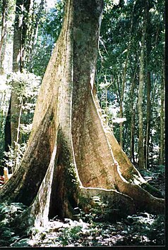
| Yellow Carrabeen Tree in Werrikimbe National Park | ||
| Werrikimbe National Park | ||
| Philoteca myoporoides - only in Werrikimbe National Park and in Queensland to find | ||
| Bag marten | ||
The Werrikimbe National Park is a national park in the northeast of the Australian state of New South Wales , 486 km north of Sydney . It is halfway between Port Macquarie and Walcha on the eastern slopes of the Great Dividing Range .
The park is part of the Hastings-Macleay Group of World Heritage Sites of the Gondwana Rainforests of Australia . The Cottan Bimbang National Park connects to the southwest, the Willi Willi National Park to the northeast and the Oxley Wild Rivers National Park to the northwest .
Overview
The Werrikimbe National Park is known for its rich flora and fauna, its rainforests , its wild rivers that are worth seeing and the opportunities for recreational activities in a remote area. In this park you can also find an Aboriginal stone structure , consisting of two rings, the Bora rings , in which initiation rites were performed.
All access roads to the park are unpaved, winding and sometimes steep. They are unsuitable for campers. Beyond Mooraback Road there is a four wheel drive lane to the visitor center at Youdales Hut . For this you have to get a key for a gate either from the national park administration or from Apsley Motors in Walcha. There are five visitor areas with simple facilities - three in the eastern part near the rock breaks and two in the western part on the plateau.
There are tent sites:
- at Brushy Mountain (20 parking spaces) on the northwest edge of the park. The space is suitable for cars with caravans (not for campers). There are toilets, a supply station, picnic tables and a wood-burning barbecue area
- in Mooraback (5 parking spaces) on the northwest edge of the park. There are restrooms, picnic tables, and a wood-burning barbecue area
- at Plateau Beach (5 parking spaces) on the east side of the park. For people who shy away from the long journey from a car to a caravan or tent. There are dry toilets, a supply station, picnic tables and a wood-burning barbecue area
The Bicentennial National Trail (hiking trail commemorating the 200th anniversary of the Australian colonies) for along the western edge of the Werrikimbe Wilderness to the sources of the Hastings River and Kunderang Brook . Horses and motor vehicles are not allowed in this protected area.
history
The area around Mooraback was one of the earliest settlements in the Falls Country east of Walcha. The first settlers were already cultivating pastures there in the 1850s. Their names appear in various hallway names in the park: Bishops Swamp , Cleghorns Creek or Careys Trail .
In the 1950s, manganese ore was mined in an area that is now part of the national park.
flora
There are a large number of vegetation zones here, depending on the frequency of precipitation and the altitude: light eucalyptus forest with coachwood (Ceratopetalum apetalum), sassafras (Atherosperma), dendrocnids , long-leaved wax flowers (Philoteca myoporoides) and yellow carabees (Sloanea woolsii) with their buttress-like trunks. There are also endangered plants such as the bird orchid (Chiloglottis anaticeps), fairy lanterns (Thismia rodway) and pygmy cypresses (Callitris oblonga, subsp. Parva). These forests are also home to the only specimens of Filmy King Fern ( Fern , Leptopteris fraseri) in all of northern New South Wales. The forest with Antarctic Book (Nothofagus moorei) at the end of the North Plateau Road will be over 1,000 years and represents the largest continuous beech forest is in Australia The endangered Pygmäenzypresse comes in northern New South Wales just on the eastern edge of the tableland of. New England in Werrikimbe National Park in front.
fauna
At least 22 endangered animal species live in Werrikimbe National Park, such as B. the sensitive rust-bellied thicket bird ( Atrichornis rufescens ). The rare, indigenous Hastings River mouse ( Pseudomys oralis ) was considered extinct until it was rediscovered in Werrikimbe National Park in 1981. This mouse lives in the heathland and in sparse forests by watercourses. Also you can bush chicken , the koala , the Black Schopf-Wippflöter ( Psophodes olivaceus ), the powerful owl ( Ninox strenua ), the Gleitbeutler ( Petaurus ), the Quoll ( Dasyurus ) and the Lyrebird ( Menura ) observed in the park.
Web links
- Werrikimbe National Park - Plan of Management . NSW Environment & Heritage Office
- Werrikimbe National Park . AustralianNationalParks.com
Individual evidence
- ↑ a b Werrikimbe Wilderness . NSW National Parks & Wildlife Service (April 1996)
- ^ Werrikimbe National Park - How to Get There . NSW Environment & Heritage Office
- ^ Threatened Species of the New England Tablelands and North-Western Slopes of New South Wales . NSW National Parks & Wildlife Service. Sydney (2003). ISBN 0-7313-6673-5
- ↑ Readers Digest Guide to Australian Places . Readers Digest. Sydney
- ↑ Pygmy Cypress Pine . Threatened Species


