Tomaree National Park
| Tomaree National Park | ||
|---|---|---|
| The coast seen from the lighthouse | ||
|
|
||
| Location: | New South Wales , Australia | |
| Specialty: | Lighthouse, gun post | |
| Next city: | Nelson Bay | |
| Surface: | 23.18 km² | |
| Founding: | November 9, 1984 | |
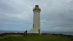
| Point Stephens Lighthouse | ||
The Tomaree National Park is a national park in the east of the Australian state of New South Wales , about 150 kilometers northeast of Sydney and 50 kilometers northeast of Newcastle , in the Local Government Area Port Stephens .
The park is on the coast of the Tasman Sea between Fishermans Bay in the south and Shoal Bay in the north. Two major attractions are Point Stephens Light , a lighthouse built in 1862, and the WWII gun post at Tomaree Head , built in 1941.
The park around Anna Bay , Fingal Bay , Shoal Bay and Nelson Bay consists of rocky stretches of coast, sandy beaches and heathland behind. Only here can the acidic volcanic rock rhyodacite be found.
Web links
Commons : Tomaree National Park - Collection of pictures, videos and audio files


