
Bago Bluff National Park
| Bago Bluff National Park | |||
|---|---|---|---|
 |
|||
|
|||
| Location: | New South Wales , Australia | ||
| Surface: | 40.23 km² | ||
| Founding: | 1999 | ||

The Bago Bluff National Park (English Bago Bluff National Park ) is located in the state of New South Wales in Australia , about 410 km northeast of Sydney and a little southwest of Wauchope , from where one has the best access to the park via the Oxley Highway . It has an area of 4023 ha and was placed under protection in January 1999.
General
Bago Bluff comprises parts of the Broken Bago State Forest and the Lome State Forest. In the national park you can enjoy sweeping views over the Hastings Valley . Petrifications have been found in the area. Bago Bluff National Park has year-round rainfall. The maximum amount of precipitation measured in one day is 310.6 mm.
Flora and fauna
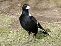
Bird species include, for example, the flute bird , the yellow-bellied thick head , fan tails , kookaburra , spotted panther bird and the thick-billed strangler crow . Endangered species are also the brown-headed cockatoo , the long-tailed fruit pigeon , the giant owl , the New Holland owl and the black owl .
- Bird species in Bago Bluff National Park
Flute bird

Spotted panther bird

Brown-headed Cockatoo

Long-tailed fruit pigeon

New Holland Owl


Further protection categories
The park also includes the Bago Bluff Flora Reserve and Six B Flora Reserve plant protection areas .
Web links
- New South Wales Government Information
- National park map
Individual evidence
- ↑ a b North East NSW Parks and Reserves - Trip report by B. Everingham, July 1999, accessed July 28, 2010
- ↑ a b Explanations of the National Park Administration
- ↑ climatic data according CECCW
A Abercrombie River | Arakoon | Arakwal | B Bago Bluff | Soon rock | Bangadilly | Barakee | Barool | Barrington Tops | Basket Swamp | Belford | Bellinger River | Benambra | Ben Boyd | Bendick | Ben Halls Gap | Berowra | Bimberamala | Bindarri | Biriwal-Bulga | Blue Mountains | Bongil Bongil | Boonoo-Boonoo | Booti-Booti | Border Ranges | Botany Bay | Bouddi | Bournda | Brindabella | Brisbane Water | Broadwater | Budawang | Budderoo | Bugong | Bundjalung | Bungawalbin | Bungonia | Butterleaf | C Capoompeta | Carrai | Cascade | Cataract | Cathedral Rock | Cattai | Chaelundi | Clyde River | Cocoparra | Columbey | Conimbla | Conjola | Coolah Tops | Coorabakh | Cottan Bimbang | Crowdy Bay | Culgoa | Cunnawarra | Curracabundi | D Dharawal | Deua | Dharug | Dooragan | Dorrigo | Dunggir | E Eurobodalla | F Fortis Creek | G Gaagal Wanggaan | Gardens of Stone | Garigal | Garrawilla | Georges River | Ghin Doo Ee | Gibraltar Range | Gir-um-bit | Gondwana rainforests | Goobang | Goolawah | Goonengerry | Goulburn River | Gourock | Gulaga | Gumbaynggirr | Gundabooka | Guy Fawkes River | H Hat Head | Heathcote | Hunter Wetlands | I Indwarra | J Jerrawangala | Jervis Bay | Junuy Juluum | K Kalyarr | Kanangra-Boyd | Karuah | Kemendok | Keverstone | Kinchega | Kings Plains | Kooraban | Koreelah | Kosciuszko | Kumbatine | Ku-ring-gai-Chase | Kwiambal | L Lachlan Valley | Lane Cove | Livingstone | M Macquarie Pass | Mallanganee | Mallee Cliffs | Mares Forest | Maria | Marramarra | Marrangaroo | Maryland | Mebbin | Meroo | Middle-Brother | Mimosa Rocks | Minjary | Monga | Mooball | Morton | Mount Clunie | Mount Imlay | Mount Jerusalem | Mount Kaputar | Mount Nothofagus | Mount Pikapene | Mount Royal | Mount Warning | Mummel Gulf | Mongoose | Murramarang | Murray Valley | Mutawintji | Myall Lakes | N Nangar | Nattai | New England | Nightcap | Nowendoc | Nymboi-Binderay | Nymboida | O Oolambeyan | Oxley Wild Rivers | P Paroo Darling | Popran | R Ramornie | Richmond Range | Royal | S Saltwater | Scheyville | Scone Mountain | Seven Mile Beach | Single | South East Forest | Sturt | Sydney Harbor | T Tallaganda | Tapin Tops | Tarlo River | Thirlmere Lakes | Tilligerry | Timbarra | Tomaree | Tooloom | Toonumbar | Toorale | | Towarri | Turon | U Ulidarra | W Wadbilliga | Wallarah | Wallaroo | Wallingat | Warra | Warrabah | Warrumbungle | Wash pool | Watagans | Weddin Mountains | Werakata | Werrikimbe | Willandra | Willi-Willi | Woko | Wollemi | Wollumbin | Woolooma | Woomargama | Worimi | Wyrrabalong | Y Yabbra | Yanga | Yanununbeyan | Yarriabini | Yarrahapinni Wetlands | Yengo | Yuraygir