
Mutawintji National Park
| Mutawintji National Park | |||
|---|---|---|---|
 |
|||
|
|||
| Location: | New South Wales , Australia | ||
| Specialty: | Red sandstone cliffs and canyons, yellow-footed rock kangaroo | ||
| Next city: | White Cliffs, Broken Hill | ||
| Surface: | 689 km² | ||
| Founding: | 4th September 1998 | ||

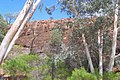
The Mutawintji National Park is a national park in the northwest of the Australian state of New South Wales , 878 kilometers west-north-west of Sydney and 130 kilometers northeast of Broken Hill .
The wild, bush-covered Byngnano Range is lined with colorful canyons, water holes and stream beds, which are lined with eucalyptus ( red gum ). Between the caves and overhangs there are isolated rock carvings and rock carvings by the Aborigines .
In 1979 the Foundation for National Parks & Wildlife bought 100 km² in the Cotarundee Ranges and fenced them in. Today this is the Mutawindji National Park, where u. a. the yellow-footed rock kangaroo is protected.
Further donations and the extermination of the fox (introduced from Europe) in the sanctuary ensured the survival of the last population of the yellow-footed rock kangaroo in New South Wales. Since the lowest level in 1995, the population of the strikingly marked kangaroo species has now increased to 300 to 400 animals.
Also part of the national park is the Mutawintji Historical Site , one of the most important collections of petroglyphs by the Australian Aborigines.
photos
River Red Gums
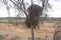
Eagle's nest in a Flindersia tree

Petroglyph of a Brolga crane


Web links
A Abercrombie River | Arakoon | Arakwal | B Bago Bluff | Soon rock | Bangadilly | Barakee | Barool | Barrington Tops | Basket Swamp | Belford | Bellinger River | Benambra | Ben Boyd | Bendick | Ben Halls Gap | Berowra | Bimberamala | Bindarri | Biriwal-Bulga | Blue Mountains | Bongil Bongil | Boonoo-Boonoo | Booti-Booti | Border Ranges | Botany Bay | Bouddi | Bournda | Brindabella | Brisbane Water | Broadwater | Budawang | Budderoo | Bugong | Bundjalung | Bungawalbin | Bungonia | Butterleaf | C Capoompeta | Carrai | Cascade | Cataract | Cathedral Rock | Cattai | Chaelundi | Clyde River | Cocoparra | Columbey | Conimbla | Conjola | Coolah Tops | Coorabakh | Cottan Bimbang | Crowdy Bay | Culgoa | Cunnawarra | Curracabundi | D Dharawal | Deua | Dharug | Dooragan | Dorrigo | Dunggir | E Eurobodalla | F Fortis Creek | G Gaagal Wanggaan | Gardens of Stone | Garigal | Garrawilla | Georges River | Ghin Doo Ee | Gibraltar Range | Gir-um-bit | Gondwana rainforests | Goobang | Goolawah | Goonengerry | Goulburn River | Gourock | Gulaga | Gumbaynggirr | Gundabooka | Guy Fawkes River | H Hat Head | Heathcote | Hunter Wetlands | I Indwarra | J Jerrawangala | Jervis Bay | Junuy Juluum | K Kalyarr | Kanangra-Boyd | Karuah | Kemendok | Keverstone | Kinchega | Kings Plains | Kooraban | Koreelah | Kosciuszko | Kumbatine | Ku-ring-gai-Chase | Kwiambal | L Lachlan Valley | Lane Cove | Livingstone | M Macquarie Pass | Mallanganee | Mallee Cliffs | Mares Forest | Maria | Marramarra | Marrangaroo | Maryland | Mebbin | Meroo | Middle-Brother | Mimosa Rocks | Minjary | Monga | Mooball | Morton | Mount Clunie | Mount Imlay | Mount Jerusalem | Mount Kaputar | Mount Nothofagus | Mount Pikapene | Mount Royal | Mount Warning | Mummel Gulf | Mongoose | Murramarang | Murray Valley | Mutawintji | Myall Lakes | N Nangar | Nattai | New England | Nightcap | Nowendoc | Nymboi-Binderay | Nymboida | O Oolambeyan | Oxley Wild Rivers | P Paroo Darling | Popran | R Ramornie | Richmond Range | Royal | S Saltwater | Scheyville | Scone Mountain | Seven Mile Beach | Single | South East Forest | Sturt | Sydney Harbor | T Tallaganda | Tapin Tops | Tarlo River | Thirlmere Lakes | Tilligerry | Timbarra | Tomaree | Tooloom | Toonumbar | Toorale | | Towarri | Turon | U Ulidarra | W Wadbilliga | Wallarah | Wallaroo | Wallingat | Warra | Warrabah | Warrumbungle | Wash pool | Watagans | Weddin Mountains | Werakata | Werrikimbe | Willandra | Willi-Willi | Woko | Wollemi | Wollumbin | Woolooma | Woomargama | Worimi | Wyrrabalong | Y Yabbra | Yanga | Yanununbeyan | Yarriabini | Yarrahapinni Wetlands | Yengo | Yuraygir