Ku-ring-gai-Chase National Park
| Ku-ring-gai-Chase National Park | ||
|---|---|---|
| West Head Lookout | ||
|
|
||
| Location: | New South Wales , Australia | |
| Specialty: | Coastal landscape, Aboriginal sites | |
| Next city: | Hornsby - Sydney | |
| Surface: | 149.77 km² | |
| Founding: | 1894/1967 | |
| Visitors: | 2,000,000 (2001) | |
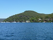
The Ku-ring-gai-Chase National Park is a national park near Sydney in Australia . It was founded in 1894, making it one of the oldest national parks in Australia . The park covers about 150 square kilometers of eucalyptus dominated bushland on sandstone - mountain ranges and some Rias , from the Pacific Ocean flooded river valleys that ultimately the two arms Cowan Creek and Pittwater in the Hawkesbury River lead.
The traditional owners of the land were the Guringai , an Aboriginal tribe . There are many artifacts of their settlement in the national park , including petroglyphs in the style of Sydney rock engravings . From 1834 whites settled in the area; Today there is only one inhabited place in the park, Cottage Point .
Since 2006, the Ku-ring-gai-Chase National Park has been listed on the Australian National Heritage List due to its high biodiversity ; There are 24 different types of vegetation in the park with a total of 13 endangered animal species.
For the residents of Sydney, the national park is a popular local recreation area with around 2 million visitors annually.
geography
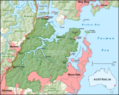
The 150 km² Ku-ring-gai-Chase National Park is located about 25 km north of Sydney city center in the Hornsby Shire and forms the northern border of the city. The national park is bordered in the south by residential areas of Hornsby and Mona Vale , in the west by the Pacific Highway , in the north by the Hawkesbury River and in the east by Pittwater , one of the rias of the Hawkesbury River. It is also bordered by the Muogamarra Nature Reserve , the Berowra Valley Nature Reserve and the Garigal National Park . The highest point, Willunga Trig , is 228 m above sea level.
The Rias Cowan Water and Pittwater are mainly fed by the Pacific Ocean via the Hawkesbury River as well as by a large number of smaller inflows: These inflows arise especially after rain, when the rainwater seeps through the sandstone soil and runs off into the rias via small waterfalls and streams. Cowan Creek has a length of 14 km and a maximum width of around 400 m. Two large main bays ( Coal and candle creek and Smiths creek ) as well as a multitude of smaller bays are rias of smaller streams. Pittwater Creek is 8 km long and up to 2 km wide, in addition to a large number of bays there is also the non-national park Scotland Island .
There are a total of four access roads into the national park. The western part of the park can also be reached by CityRail : hiking trails lead into the park from Cowan Station , Berowra Station and Mt Ku-ring-gai Station . Boats can travel to the various bays from the Hawkesbury River and anchor at three marinas ( Bobbin Head , Akuna Bay and Cottage Point ) as well as 48 public moorings in the park.
climate
Like Sydney, the national park is located in the subtropical climate zone. The average maximum temperature fluctuates between 17 ° C in winter and 26 ° C in summer; the average temperature minimum is between 8 ° C in winter and 18 ° C in summer. The lowest measured value is −3.5 ° C, the highest 43.1 ° C.
The rainfall is an average of 120 mm (January) to 140 mm (March) per month in summer the highest and can reach mm in one day up to 253rd In the dry winter - July to September - an average of 60 mm per month is recorded.
geology
The national park is located on part of the Sydney Basin , a 60,000 km² sedimentary basin of a large freshwater lake, in which sand, mud and silt were deposited during the Triassic 290 to 200 million years ago, which was then compacted into rock.
The layered, dense and fine-grained slate of the Narrabeen Group belongs to the lowest rock layer . This formation is also the origin of the oldest mountains in the park, which emerge at a low elevation of 20 to 40 meters on the coast of Pittwater , Cowan Water , north of Cottage Point and at the end of Barrenjoey Head. The weathered Narrabeen slate forms the relatively red clay soil. Above it lies the granular Hawkesbury sandstone , which is composed of cemented quartz grains . This sandstone is the most common rock of the plains and hills in the park. The weathering of the Hawkesbury sandstone formed the extensive sandy soils on the heights and the yellow earth in the deep valleys. The top layer was the Wianamatta Group , which is now largely eroded.
2 to 12 million years ago, the Hornsby Plateau , on which the Ku-ring-gai-Chase National Park is located, rose 150 to 250 m. It fell dry so that weathering and erosion formed the plateau. The last period of erosion took place in the last Ice Age , when the sea lay deeper and the V-shaped valleys in the plateau were formed by running rivers. At the end of the glacial period, the valleys were flooded and the heights of Lion Island , Long Island , Spectacle Island and Barrenjoey Headland were carved out; then a land bridge was created by deposits, which connected Barrenjoey Head with the mainland.
Lava penetrated crevices 65 to 40 million years ago ; therefore there is also a few lava stones in the park. Weathering of the lava rock formed red and particularly fertile soils on West Head near the picnic spots, while deeply weathered and shattered volcanic rock formed the valleys at Campbells Crater and Smith Crater and near Smith Creek at Cowan Water .
From 1901 on, quarries were created on the park area for building blocks and road material. The Bobbin Head Road as well as the early sandstone buildings on the park grounds are out of this sandstone. The quarries are now abandoned, represent historical evidence and will not be changed. Two other quarries in the park are still in use on a case-by-case basis.
Ecosystems


In Ku-ring-gai Chase National Park were from the Flora of Australia so far more than 1,000 plant species discovered in 24 types of vegetation and extensively studied in a number of studies. The vegetation types in the ecosystems of heather , woodland, open forest and subtropical rainforest are summarized . The various ecosystems are home to parts of Australia's fauna , namely an estimated 100 species of butterflies , various snakes and lizards , 160 species of birds and 28 native mammal species , most of which are unique to Australia. 13 animal species, according Threatened Species Conservation Act are listed as threatened, have a habitat in the park: In addition to the Koala also short-nosed bandicoot , tiger quoll , several bat species , the Schreiber's bat , the Großfüßige mouse-eared , glossy black cockatoo and swift parrot , powerful owl and Australian Masked Owl , the leatherback turtle , the Rosenberg's monitor lizard as well as a frog and a toad species ( Heleioporus australiacus and Pseudophryne australi ). The list of animal species in Ku-ring-gai-Chase National Park gives an overview of other animal species. In a study from 1972, 18 of the butterfly species are named: 18 of the thick-headed butterfly family , 4 of the knightly butterflies (including the Papilio demoleus sthenelus ), 7 whites , 12 noble butterflies (including the monarch butterflies ) and 7 blues .
pagan
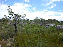
Dry heather is on the water-permeable hills on sandstone ; here there are mainly bushes with low-growing Banksia species ( Banksia oblongifolia , Banksia ericifolia ), Boronia species ( Boronia pinnata , Boronia serrulata , Boronia floribunda ) and the Australian tea tree ( Melaleuca alternifolia ). These species bloom mostly in spring, so from September to November, and attract large numbers of seed and nectar-eating birds, such as parrots ( swift parrot , Rosella , Pennant parakeet , rainbow lorikeet ) and honeyeater (including New Holland honeyeater , noisy friarbird , gold ear-Honigfresser ) . The honey-eaters benefit from the fact that they have long, narrow beaks that enable them to reach nectar . According to the Australian fauna, most of the mammals are marsupials , such as the various Possum species (for example short-nosed beetles , short-headed glide-owed bees ); Wallabies are rarer - they also inhabit the heather, as do most snakes and lizards. Australia's largest bird of prey , the wedge-tailed eagle , has its hunting ground here.
Moist heather is on slate , which is covered with a thin layer of clay and is therefore impermeable to water. Again there are different types of Banksia that tolerate high humidity at times, for example Banksia robur .
Heath societies overgrown the mountain ridges because the Guringais burned the mountain ridges every 1–5 years. In doing so, they supported the spread of those plant species that survive fire unscathed or, like the Banksia species, even need them for their reproduction and are relatively fast-growing.
Woodland
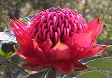
In the somewhat lower-lying woodland in protected locations on slopes with a low incline and sandy soil, there are mainly larger trees: Various eucalyptus species dominate , such as Eucalyptus haemastoma and Eucalyptus gummifera . Among other things, the shrub Telopea speciosissima grows there . Parakeets and cockatoos use the cavities in tree trunks as breeding grounds; and possums can be found here.
Open forest
Open Forest grows deeper in the more humid drainage channels, where various eucalyptus species ( e.g. Eucalyptus maculata , Eucalyptus paniculata and Eucalyptus piperita ) and boronia species ( Boronia mollis , Boronia fraser ) can also be found. Both Woodland and Open Forest are home to the koala , which feeds on most eucalyptus species, as well as various types of eagles ( osprey , white-bellied sea eagle ) that rest on tall trees.
Rainforest
Temperate rainforest has been preserved in particularly protected and humid locations such as Jerusalem Bay . In contrast to the eucalyptus-rich areas, the rainforest stands on composting humus soil that is rich in nutrients and insects. Gray-backed lyre-tail and laughing Hans are looking for food here. The rainforest is also the preferred settlement area for the giant bag marten . This rainforest contains, for example, Tristiniopis laurina , Acmena smithii , Backhousia myrtifolia and the palm species Livistona australis as well as tree fern species.
Waters
In the branches of the Hawkesbury River, in the Pittwater and in the Cowan Water, marine conditions with brackish water and tidal range prevail as they are rias . Rias arise in the deeply cut valleys formed by rivers; the Pacific Ocean has been flooding these valleys since sea levels began to rise around 12,000 years ago with the beginning of the current warm period .
Most of the waters have their water catchment area exclusively within the Ku-ring-gai-Chase National Park and are of good water quality. Occasionally, boats with oil, gasoline or sewage pollute these areas, which then leads to problems when smaller bays are only slightly washed by the tidal range. Some bodies of water have their catchment areas in inhabited areas and are overloaded with nutrients.
Common fish include snapper and other perch species ; occasionally bull sharks are found that breed in the Hawkesbury River; dolphins have also been spotted in the waters. Oysters ( Saccostrea glomerata ) grow on rocks that are at least temporarily under water .
Mangroves ( Avicenniea marina and Aegicerras corneculatum ) can be found in some areas in the range of the tidal range. Different types of crabs live here. Azure fishermen , ibis and various species of cormorants fish in the park.
Recreational fishing with angling is allowed in the park from both boats and land. Fishing with nets was banned as early as 1894, as was the gathering of crustaceans. Anglers have created environmental problems in some parts of the park with fires, rubbish, and fishing lines lying around with animals becoming entangled.
Protective measures

Neophytes , that is, introduced plants, grow primarily along the waters that have their catchment area in residential areas. Groups of volunteers take part in control programs that remove the unwanted plants by hand and restore natural vegetation. Individual areas have already been rated as successful and exemplary. Introduced European animals ( neozoa ) such as foxes , domestic cats , dogs , rabbits , rats and mice threaten the native animals because they either hunt for them or are food competitors. The park administration sees the fox in particular as a threat and has therefore placed bait along the streets and paths, as the fox prefers to move on them. Neighboring residents such as a neighboring golf club are included in the control programs by reducing the number of rabbits on their property, which are both food competitors for local animals and keep the fox population high as food.
Several Eucalyptus and Banksia species have been adapted so that their seeds only fall out of the fruit at high temperatures, which is why they need bushfires , which have been part of the natural ecological cycle in Australia for thousands of years , for reproduction. Eucalyptus species evaporate highly combustible essential oils and thus even encourage bush fires, so that competing plant species that are not fire-resistant are displaced. Grass initially grows on burnt-out areas, which is a habitat and food for wallabies, for example, which were hunted by the Aborigines.
Bushfires are also monitored by the park administration. Where it makes ecological sense, the park administration burns down individual areas in a controlled manner. Parts of the park that are close to inhabited areas or important cultural sites are protected from fire by aisles; if necessary, counterfire will be set. Naturally occurring fire is controlled and only contained as it approaches protected areas. Rainforests are also protected because, unlike eucalyptus, they are irretrievably destroyed by fire. Ku-ring-gai-Chase National Park is repeatedly included in studies that deal with bushfires and their effects on flora and fauna.
Larger bushfires occur naturally about every 15 to 25 years. The Guringai burned the mountain ridges every one to five years. For the past 50 years there have been around 10 small bush fires each year, mostly caused by arsonists or carelessness; there were two great fires in every decade. The last major fire was in 1994 and affected around 50% of the site; he also made international headlines.
history
Ku-ring-gai

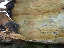
Traditionally the land belonged to the Guringai (also spelled Ku-ring-gai ), an Aboriginal tribe . The Garrigal and Terramerragal clans lived in the area of today's national park . The duration of the settlement is estimated to be at least 7,400 years, in some sources to 15,000 to 20,000 years. Around 800 Aboriginal sites with traces of the indigenous population are known; some can be visited. The rock paintings and rock carvings of the Guringai are estimated to be at least 600 years old. The rock painting that can be viewed is in the Red Hands Cave : the outlines of hands are painted with red ocher . It is close to the West Head Lookout . There are several rock carvings that are part of the Sydney rock engraving , an art style that is otherwise not found in Australia. Many of these rock carvings, such as those of a great emus or those of a man and a woman under a sickle, are associated with Aboriginal astronomy : The great emu in the rock carving on the Elvina Trail is shown in an unnatural position; but at the time when emus lay eggs it has the same shape and orientation of a series of dark clouds in the Milky Way , of which the coal sack is supposed to represent the head of the emus. Man and woman, on the other hand, symbolize the moon and sun; the man who partially obscures the woman, as at the Basin Track Site , therefore represents a solar eclipse . Since the Guringai culture was lost before it could be recorded by scientists, these assumptions are based on research with Warlpiri and Yolngu from the Northern Territory , as their traditional spiritual life is still almost intact and accessible to science today.
Other traces of Aboriginal people come from stone tools, such as stone axes , which were cut on the rock, leaving furrows. Garbage dumps with the remains of marine animals that served as food also testify to earlier settlement and the way the Guringai lived .
European settlement
As early as March 1788, six weeks after the First Fleet arrived in Sydney, Governor Arthur Phillip made the first expedition to the Hawkesbury River and examined Pittwater. The first encounters with the Guringai were peaceful. By 1795, it is estimated that half of all Guringai had died from a smallpox epidemic . From 1793 whites settled further west on the banks of the Hawkesbury River; this resulted in an open war with the Darug , which lasted until 1805. Displaced from their habitat, the Darug settled on Pittwater. By 1840 almost all of the Aborigines had also disappeared from here.
In the period from 1790 to 1840, refugees from the Australian convict colony, in particular , stayed on the land of today's national park, which was still uninhabited by whites, and tried to get on anchored ships in order to flee further. From 1834 large plots of land were awarded: William Lawson , a discoverer of the Blue Mountains , received 260 hectares on the Lambert Peninsula ; others were allowed to take over parts of The Basin , Little Mackerel and Great Mackerel Beach , Soldiers Point and Cottage Point . Because of the hilly and very rocky terrain with rather nutrient-poor soils, commercial agriculture and livestock did not take place; the land was considered to be rather worthless.
In Pittwater in particular, a boat building industry and timber extraction established themselves. Soap was also made from the ashes of burned mangroves and the water evaporated to produce salt. The shells of mussels and snails were gathered to make lime for masonry mortar. The products were shipped to Sydney by boat.
Tourism developed when, during an economic boom in Sydney in 1879, a boat dock was opened in Newport , a hotel and guest house opened, and the increasingly affluent townspeople sought weekend relaxation outside the city.
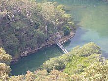
A railway line made it possible to visit the west of today's park since 1887: Motivated by the construction plans, Edward Windybank settled there in Waratah Bay in 1886 . He built a house, then a second, and finally a boathouse. As a trained boat builder, he had built 30 boats for hire by 1894. At the height of his success he had 60 row boats and 13 houseboats, as well as several cabins. Windybank's Paradise was family owned until 1959 . After that, neglected, the remains burned down in a bush fire in 1972; Today you can still see a rusted steel frame of a houseboat and a ramp.
National park
The national park was founded on December 14, 1894 on the initiative of a citizen named Eccleston du Faur under the name Ku-ring-gai Chase . Chase stands for a natural landscape that is not fenced; Ku-ring-gai is an alternative spelling for the Aborigines of the Guringai tribe . The boundaries of the national park have not changed since it was founded: only West Head and Barrenjoey Head did not belong to the park from the beginning. Du Faur had campaigned for the establishment of a nature reserve because florists had removed plants for miles along the coast to sell in Sydney. To achieve his goal, he had already invited the influential Governor of New South Wales , Victor Child Villiers , to a picnic in what is now the park grounds in 1892 .
The park was initially managed by a foundation with twelve board members, of which du Faur himself was the executive chairman from 1894 to 1904. The main task of the foundation was to market the 14.2 hectare park as a recreation area: paths were set up for this purpose; from 1901 the road to Bobbin Head as well as stables and toilets. While in the Royal National Park, also located near Sydney and founded only a few years earlier, the economic use of the park by logging was allowed, in the Ku-ring-gai-Chase National Park nature conservation was so central that commercial timber was banned from the start .
In 1967 the newly established NSW National Parks & Wildlife Service took over the park and manages it together with the Lion Island, Long Island and Spectacle Island Nature Reserves, which are located on the Hawkesbury River. The NSW National Parks & Wildlife Service is now part of the Department of Environment, Climate Change & Water . The NSW National Parks & Wildlife Service is committed to the guidelines of the International Union for Conservation of Nature and Natural Resources for protected areas of category II: According to this, goals are to protect the ecological integrity, prevent harmful use and enable recreation, education and science.
The Ku-ring-gai-Chase National Park was temporarily filming location for the Australian television series Skippy, the kangaroo .
tourism
Every year around 2 million people visit the park. According to a study by the park administration, the most popular destinations are Bobbin Head and the West Head observation deck. Picnicking, barbecuing and hiking are the most common activities. 43% of all visitors had already been to Ku-ring-gai-Chase National Park in the previous three months; almost 90% come from within 20 km of the park.
There are on-site restaurants at Cottage Point , Akuna Bay, and Bobbin Head , plus several gas-fired BBQ areas and simple picnic areas with tables and benches.
If you don't bring your own boat into the park, you can rent a boat in a boat rental in Bobbin Head , in Akuna Bay or outside the park, for example in Brooklyn . Accommodations are privately held at Cottage Point and on Mackerel Beach . There is a campsite in the Basin Camping Area; a hostel in Towlers Bay. Both the campsite and the youth hostel can only be reached on foot or by boat, for example a water taxi.
The park administration has set up a good dozen hiking trails of various lengths and degrees of difficulty. You can cycle and ride on horseback on some designated trails. Climbing and abseiling is only permitted after a case-by-case examination. The park is closed at night because nocturnal visitors used to cause many forest fires and nocturnal animals were run over on the streets.
Cottage Point
Around 1880 the place was named Terry's Point after its resident James Terry. Several historically significant sandstone and wooden buildings are still preserved from this early settlement period. Cottage Point is the only place still inhabited today, 98 people currently live there. Various companies serve tourism: there is a yacht club, boat rentals, a restaurant, water taxis and seaplanes. Some of the houses are rented out to vacationers.
Bobbin Head
As early as 1894 there was a barrack accessible on foot or by boat. Eccleston du Faur contributed financially to the construction of a road to Bobbin Head from 1901 . He asked the owner at the time to build toilets and stables - stables because it was customary at the time to arrive on horseback or in a horse and cart. From 1903, after the road was completed, Bobbin Head began to flourish as a tourist destination; Food and drinks were available for purchase and boats were hired out. Most of the facilities that can still be seen today were built in the 1930s through government-sponsored employment of the unemployed. The Bobbin Inn housed a restaurant and dance hall at the time. In order to gain land, the muddy bay was raised; Stone walls are supposed to prevent erosion .
In the 1950s, Bobbin Head was expanded again: a children's playground, swimming pool and train were built. A koala enclosure was built not far.
When the National Parks and Wildlife Service took over the park, it rebuilt Bobbin Head in the 1970s on the facilities of the 1930s. The Bobbin Inn hosts since then next to a restaurant, the information center of the park administration. A wooden walkway was built that leads through the mangroves so that different types of crabs can be observed at low tide . The koala enclosure is now home to the Kalkari Visitor Center (in the Guringai language , Kalkari means "waiting"), which provides information about flora and fauna as well as Aborigines: the building houses a permanent exhibition with tools, weapons and handicrafts of the Aborigines , which also include informs the different habitats . Various animals of the park are settled in the fenced outdoor area; Birds are attracted with food.
The Basin
Like the other previously inhabited parts of the national park, land rights to The Basin were granted from 1834. In 1882 the then owner, Frederick Jackson, an insurance broker, built Beechwood Cottage , his holiday home. This house now houses an exhibition on the more than 200-year history of Pittwater and The Basin, as well as a replica of a rock overhang used by the Aborigines for protection.
Barrenjoey Headland
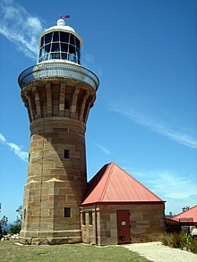
A first navigation light was installed on Barrenjoey Headland in 1855 and replaced by the first lighthouse in 1868 . Today's lighthouse was built in 1881; it is the only lighthouse in New South Wales whose sandstone walls have not been painted. In 1932 the lighthouse was finally automated. At the foot of the lighthouse, a customs house was opened in 1843, which should prevent the widespread smuggling of rum; it remained active until 1904.
West Head
After the discoverer William Lawson, various private individuals held property rights to West Head until 1929 when the West Head Riviera Company took over a large part to build a golf club, hotel and casino. Because of the Great Depression , these plans did not materialize. Instead, fortifications, cannons and various dwellings for the Navy were built during World War II. In 1951 West Head was given to the national park.
literature
- NSW National Parks & Wildlife Service: Ku-ring-gai Chase National Park. 1996, ISBN 0-7310-0813-8 .
- NSW National Parks & Wildlife Service: Ku-ring-gai Chase National Park and Lion Island, Long Island and Spectacle Island Nature Reserves. (PDF; 260 kB). 2002 (english)
Individual evidence
- ^ NSW National Parks & Wildlife Services, p. 3.
- ↑ Overview . Department of the Environment, Water, Heritage and the Arts.Retrieved January 15, 2010.
- ^ NSW National Parks & Wildlife Service (2002), p. 17.
- ^ Bob & Ann Young: Understanding the Scenery. Royal National Park and Heathcote National Park. Envirobook, Annandale 2005, ISBN 0-85881-210-X .
- ^ NSW National Parks & Wildlife Service (1996), map
- ↑ a b c d DECC Ku-ring-gai Chase National Park: Climate , accessed January 13, 2010.
- ↑ Map of the Sydney Basin , accessed January 24, 2010.
- ^ NSW National Parks & Wildlife Service (2002), p. 17.
- ^ A b c Department of the Environment, Water, Heritage, and the Arts: Australia's National Heritage - Ku-ring-gai Chase National Park. ( Memento of March 17, 2011 in the Internet Archive ) (PDF; 173 kB). 2006, accessed January 15, 2010.
- ↑ All ecosystems mentioned in this chapter and their description come from NSW National Parks & Wildlife Service (1996) , if no other source is named . Pp. 23-33.
- ^ NSW National Parks & Wildlife Service (2002), p. 20.
- ^ NSW National Parks & Wildlife Service (2002), p. 25.
- ^ AB Rose: Additional Records of Butterflies from Ku-ring-gai Chase National Park, New South Wales. In: Australian Entomological Magazine. (2), 1972, pp. 5-6.
- ^ A b NSW National Parks & Wildlife Service (2002), p. 33.
- ^ NSW National Parks & Wildlife Service (2002), p. 54.
- ^ NSW National Parks & Wildlife Service (2002), p. 29.
- ^ NSW National Parks & Wildlife Service (2002), p. 37.
- ↑ David Morrison et al .: Conservation conflicts over burning bush in south-eastern Australia. In: Biological Conservation. (76), 1996, 2, pp. 167-175.
- ↑ Belinda Kenny: Influence of multiple fire-related germination cues on three Sydney Grevillea (Proteaceae) species. In: Australian Ecology. (25), 2000, 6, pp. 664-669.
- ↑ Sad stumps . In: Der Spiegel . No. 3 , 1994 ( online ).
- ^ A b Hornsby Shire Council: History of Hornsby Shire. ( Memento of April 26, 2007 in the Internet Archive ) accessed January 12, 2010.
- ↑ Ray Norris: Sydney Aboriginal Rock Engravings: Ku-ring-gai Chase National Park , accessed January 20, 2010.
- ^ A b Ray P. Norris Searching for the Astronomy of Aboriginal Australians. ( Memento of May 12, 2011 in the Internet Archive ) (PDF; 392 kB), (English), accessed on January 20, 2010.
- ^ NSW National Parks & Wildlife Service (2002), p. 30.
- ^ NSW National Parks & Wildlife Service (2002), p. 9.
- ^ NSW National Parks & Wildlife Service, (1996) p. 14.
- ^ NSW National Parks & Wildlife Service (2002), p. 2
- ↑ Ken Beck: The encyclopedia of TV pets: a complete history of television's greatest . 2002, ISBN 1-55853-981-6 , p. 282.
- ^ NSW National Parks & Wildlife Service (2002), p. 47.
- ↑ Cottage Point Story , accessed January 27, 2010.
- ↑ Cottage Point. 2016 Census QuickStats. Australian Bureau of Statistics.
- ^ NSW National Parks & Wildlife Service (2002), p. 12.
Web links
- Official Homepage (English)
- Virtual tour


