Barrenjoey Headland
| Barrenjoey Headland | ||
 Barrenjoey Headland Lighthouse |
||
| Geographical location | ||
|
|
||
| Coordinates | 33 ° 34 '50 " S , 151 ° 19' 43" E | |
| Waters 1 | Pittwater | |
| Waters 2 | Hawkesbury River | |
Barrenjoey Headland is a peninsula that closes the Ria Pittwater at the northern end and has been part of the Ku-ring-gai-Chase National Park since 1998 . The peninsula is connected to the mainland by a strip of dunes called a tombolo and is part of the Palm Beach suburb of Sydney in New South Wales , Australia . The peninsula consists of Sydney sandstone , of the slate of Narrabeen Group superimposed.
history
Barrenjoey was formed as an island about 18,000 years ago when an ice age came to an end and the river valleys of this area were flooded. The resulting island was probably later reconnected to the mainland.
On March 2, 1788, the first governor of the Australian convict colony, Arthur Phillip, named the peninsula "Barrenjuee" (which means little kangaroo or wallaby ) while on an exploration trip . The name has been pronounced differently over the years and it was only since 1966 that the name Barrenjoey has been generally recognized.
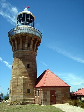
On the island is the Barrenjoey Head Lighthouse , built from Hawkesbury sandstone in 1881. Today's Barrenjoey Head Lighthouse is a lighthouse and lighthouse keeper's house built on the peninsula by the colonial architect James Barnet . A customs post was established on Barrenjoey Headland in 1843 to control trade towards Sydney from rum smuggling ; it was closed in 1903.
tourism
The island is often hiked from a parking lot at Palm Beach and offers views of the coastal landscape and Broken Bay .
Individual evidence
- ↑ a b Barrenjoey Head Lighthouse at Palm Beach on www.lighthouse.net.au ( Memento from February 21, 2011 in the Internet Archive )
Web links
- NSW Environment & Heritage Barrenjoey Headland Precinct Draft Conservation Management Plan , accessed November 11, 2012

