Hawkesbury River
|
Hawkesbury River Deerubbun River |
||
|
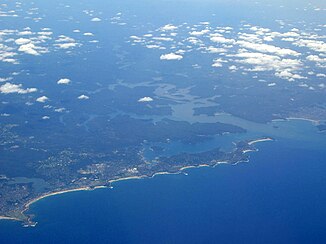
Aerial view of the Hawkesbury River and Sydney's north coast |
||
| Data | ||
| location | New South Wales , Australia | |
| River system | Hawkesbury River | |
| Drain over | Hawkesbury River → Tasman Sea | |
| source | At Richmond by the confluence of the Nepean and Grose Rivers 33 ° 36 ′ 34 ″ S , 150 ° 41 ′ 59 ″ E |
|
| Source height | approx. 38.5 m | |
| muzzle | south of Blackwall in the Tasman Sea Coordinates: 33 ° 31 ′ 50 " S , 151 ° 14 ′ 31" E 33 ° 31 ′ 50 " S , 151 ° 14 ′ 31" E |
|
| Mouth height | 0 m | |
| Height difference | approx. 38.5 m | |
| Bottom slope | approx. 0.31 ‰ | |
| length | 126 km | |
| Catchment area | 21,730 km² | |
| Drain |
MQ |
-14,905 m³ / s |
| Left tributaries | Grose River , Roberts Creek, Colo River , Webbs Creek, Macdonald River , Mangrove Creek | |
| Right tributaries | Nepean River , South Creek , Cattai Creek, Little Cattai Creek, Marramarra Creek, Berowra Creek | |
| Medium-sized cities | Richmond , Windsor | |
| Small towns | Freemans Reach, Gronos Point, Sackville, Sackville North, Lower Portland, Wisemans Ferry, Lower Hawkesbury, Spencer, Mooney Mooney, Patonga | |
| Navigable | from Windsor | |
|
Panorama of Broken Bay , where the Hawkesbury River meets the Pacific Ocean |
||
The Hawkesbury River is one of the main rivers on the coast of the Australian state of New South Wales . Together with its tributaries, it encloses the Sydney metropolitan area .
This river was one of the main transport routes for bringing food from the area to Sydney in the 19th century. Today the Hawkesbury River hosts the second largest commercial fishery, with shrimp and oyster farming and water sports.
geography
course
The Hawkesbury River has its origin at the confluence of the Nepean and Grose Rivers , north of Penrith . Both rivers are already quite large when they meet and together form the Hawkesbury River.
The tributaries Avon River , Cataract River and Cordeaux River all begin just a few kilometers from the sea, about 80 km south of Sydney. They flow first inland and then down a steep step at Wollongong . As they continue, they meet to the northwest and further away from the sea, where they form the Nepean River. We continue along Camden and Penrith.
Near Penrith, the Warragamba River flows from the Blue Mountains into the Nepean. The Warragamba is made up of the confluence of the Wollondilly River , Nattai River , Kowmung River, and Coxs River , all of which drain the eastern side of the Great Dividing Range .
The Grose River, which is the other major component of the Hawkesbury River, has its source near Mount Victoria in the Blue Mountains.
The Hawkesbury River generally runs north, meandering several times. He passes Richmond and Windsor , which are the largest settlements along the river. Further north, the area is more agricultural, with only a little inhabited area. Places here are Sackville and Lower Portland; here the Hawkesbury River meets the Colo River . The Colo River and its tributaries drain the northern part of the Blue Mountains.
From Lower Portland, the Hawkesbury River continues north to the small town of Wisemans Ferry . A tributary here is the Macdonald River . The course of the Hawkesbury River now changes to the east; the surrounding landscape is now steeper and more rugged. At Spencer , Mangrove Creek flows into the river from the north. From here to the confluence with the Pacific Ocean, there are only a few accesses to the river by car.
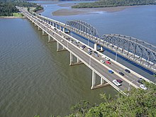
At Milsons Passage, Berowra Creek flows from the south into the Hawkesbury River. At Brooklyn , the river is crossed by the Pacific Highway and a rail bridge. Eventually the river reaches the ocean at Broken Bay .
From the confluence of the Nepean and Grose Rivers to the sea, the Hawkesbury River has a total length of 126 km.
Islands
There are the following islands on Hawkesbury, in order of flow direction:
- Milson Island
- Peat Island
- Spectacle Island
- long Island
- Dangar Island
- Lion Island
Crossings
- Richmond Bridge, a bridge in Richmond that carried the Bells Line of Road and formerly the railroad between Richmond and Kurrajong
- Windsor Bridge, a bridge in Windsor, the Putty Road bears
- Sackville Ferry, Cable Ferry
- Lower Portland Ferry, Cable Ferry
- Webbs Creek Ferry, Cable Ferry
- Wisemans Ferry, cable ferry for the Great North Road
- Hawkesbury River Freeway Bridge, a bridge from Kangaroo Point to Mooney Mooney
- Peats Ferry Bridge
- Hawkesbury River Railway Bridge
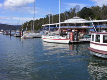
In the lower waterways are a number of pedestrian ferries that cross the river, including from Palm Beach , Ettalong, and Wagstaffe, and from Brooklyn to Dangar Island and Little Wobby.
history
Aboriginal
The Aborigines of the area named the river Deerubbun . Three Aboriginal tribes inhabited the areas the Hawkesbury River crosses: the Darug to the west and south, the Guringai to the south, and the Darkinjung to the north.
White colonization
In 1788 two expeditions explored the Hawkesbury in the northwest of Sydney and the Nepean River in the southwest. It took about three years for the explorers to realize they were exploring the same river system.
The Hawkesbury River was one of the main routes for bringing food from the area to Sydney in the 19th century. Covered by Broken Bay and Pittwater , they then waited for suitable weather to sail along the coast to Sydney in the ocean. When the railroad ran from Sydney to Windsor in 1864 , food was shipped to Windsor and then transported by train. In the 1880s, the river silted up between Sackville and Windsor, leaving seaworthy ships only to reach Sackville. The connection between Sickville and Sydney was maintained by steamers until the end of the 19th century.
The Hawkesbury River was named by Governor Arthur Phillip in June 1789 after Charles Jenkinson, 1st Earl of Liverpool , who at the time was named Baron Hawkesbury . An obelisk was unveiled in Brooklyn in 1939 to commemorate this naming.
In 1794, 22 families were granted land rights in Bardenarang, now known as Pitt Town Bottoms, near Windsor. In the same year clashes broke out between Aborigines and settlers.
use
Navigability
The Hawkesbury River is navigable from Windsor to the ocean. There are no dams or locks; the effect of the tidal range can be seen as far as Windsor.
While the transport of goods such as fruit and vegetable products is taken over by road traffic, the river remains the only access route for a number of towns and houses, especially in the lower reaches, where steep and rocky terrain has hindered road construction so far. A mail ship therefore delivers the mail between Brooklyn and Spencer.
Sports
The Hawkesbury Canoe Classic is a 69-mile (111 km) canoe race held annually in October or November. The race starts in Windsor and ends in Brooklyn. The Bridge to Bridge Water Ski Classic is a water ski race that runs in the opposite direction: it starts at Dangar Island and ends in Windsor.
Commercial fishing
After the Hawkesbury Nepean Catchment Management Authority , the Hawkesbury River estuary is the second largest commercial fishery with a yearly wholesale value of AUD 6.3 million (around EUR 3.8 million); Shrimp and oysters (prior to the onset of QX disease) are the main products.
In art and media
- Australian writer Kate Grenville wrote a historical novel called The Secret River , which is set on the Hawkesbury River.
- The film Oyster Farmer with Alex O'Loughlin (2004)
- The artist William Piguenit painted the Hawkesbury River in the late 19th century
- Various Australian television series such as A Country Practice and Home and Away have used the Hawkesbury for outdoor scenes.
- One of the main locations in Rainer M. Schröder's historic youth novel " Abby Lynn " is on the Hawkesbury River.
See also
Web links
- Satellite Photo Hawkesbury River on Google Maps
- The Hawkesbury Nepean Catchment Management Authority website
- Hawkesbury Historical Society website
- Hawkesbury Web
Individual evidence
- ↑ a b c Map of Hawkesbury River, NSW . Bonzle.com
- ^ A b Geographical Name Register Extract for Hawkesbury River . Geographical Names Board of New South Wales. Archived from the original on May 26, 2011. Info: The archive link was automatically inserted and not yet checked. Please check the original and archive link according to the instructions and then remove this notice. Retrieved December 19, 2008.
- ^ Sydney Basin Regional History . National Parks and Wildlife. Archived from the original on September 11, 2006. Info: The archive link was inserted automatically and has not yet been checked. Please check the original and archive link according to the instructions and then remove this notice. Retrieved January 16, 2007.
- ^ Journeys in Time - Australian Aboriginal Tribes . A joint project between Macquarie University and the State Library of New South Wales. Archived from the original on February 24, 2007. Info: The archive link was inserted automatically and has not yet been checked. Please check the original and archive link according to the instructions and then remove this notice. Retrieved January 16, 2007.
- ↑ James J Macken: Martin Burke The Father of Pittwater . National Library of Australia,.
- ^ Sackville Ferry . New South Wales Roads and Traffic Authority. Retrieved November 18, 2008.
- ^ Jean Purtell: The Mosquito Fleet: Hawkesbury River Trade and Traders 1794-1994 1995.
- ^ Hawkesbury River . National Museum of Australia. Retrieved January 3, 2011.
- ^ Hawkesbury River - Windsor Tide Times . www.tide-times.com.au. Archived from the original on July 31, 2008. Info: The archive link was automatically inserted and has not yet been checked. Please check the original and archive link according to the instructions and then remove this notice. Retrieved December 19, 2008.
- ^ Australia's last riverboat Postman . Hawkesbury River Tourist Services Pty Ltd. Retrieved December 19, 2008.
- ^ Hawkesbury Canoe Classic . Hawkesbury Canoe Classic. Retrieved December 19, 2008.
- ↑ Bridge to Bridge Ski Race . NSW Water Ski Federation. Archived from the original on July 19, 2008. Info: The archive link was inserted automatically and has not yet been checked. Please check the original and archive link according to the instructions and then remove this notice. Retrieved December 19, 2008.
- ↑ Hawkesbury River Subcatchment . Hawkesbury Nepean Catchment Management Authority. Retrieved January 5, 2007.


