Bell's Line of Road
| Bell's Line of Road | ||||||||||||||||||||||||||||
|---|---|---|---|---|---|---|---|---|---|---|---|---|---|---|---|---|---|---|---|---|---|---|---|---|---|---|---|---|

|
||||||||||||||||||||||||||||
| Basic data | ||||||||||||||||||||||||||||
| Operator: | Roads and Maritime Services | |||||||||||||||||||||||||||
| Start of the street: |
|
|||||||||||||||||||||||||||
| End of street: |
Bell ( NSW ) ( 33 ° 31 ′ S , 150 ° 17 ′ E ) |
|||||||||||||||||||||||||||
| Overall length: | 60 km | |||||||||||||||||||||||||||
|
States : |
||||||||||||||||||||||||||||
| Bell's Line of Road | ||||||||||||||||||||||||||||
|
Course of the road
|
||||||||||||||||||||||||||||
The Bells Line of Road is a main road in the east of the Australian state of New South Wales . It connects the Hawkesbury Valley Way in Richmond with Chifley Road in Bell in the Blue Mountains .
The road is part of State Road 40, which connects northwest Sydney with the city of Lithgow .
history
The road runs along an old Aboriginal migration route , which was established in 1823 by guides Darug men Emery and Cogy to the explorer and politician Archibald Bell Jr. (1804-1883). The expedition was accompanied by surveyor Robert Hoddle and the new route over the Blue Mountains became known as the Bells Line . The path was later cleared and a second road over the mountains was created next to the Great Western Highway , which was rarely used before the Second World War .
Between 1939 and 1949, the Bells Line of Road was significantly expanded in order to be able to serve as an alternative to the main road that runs further south, especially during the war.
Even today the road is still popular as an alternative route, especially with tourists.
course
The Bells Line of Road begins in Richmond, where it continues as the Hawkesbury Valley Way (S40) over the Richmond Bridge , which crosses the Hawkesbury River . Through the village of Kurmond and past Kurrajong , the road leads over the Bells Range and through Kurrajong Heights . On the ridge of the mountains, the Bells Line of Road crosses the villages of Bilpin and Berambing with their orchards.
Then the road leads up to Mount Tomah , which is known for its botanical garden at an altitude of around 1,000 m, past Mount Bell and Mount Charles , over Pierces Pass and to Mount Banks . 8 km before Bell branches off a narrow road to the north to Mount Wilson and Mount Irvine . From the village of Bell the street is called Chifley Road (S40).
Road conditions and speed limits
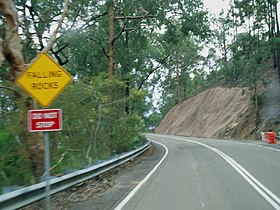
The road is steep and winding for long stretches. On Bellbird Hill it rises 450 m from the valley of the Hawkesbury River to the Bell Range . Partly a 12.5% gradient is reached and there are several tight curves. Other steep sections of the route are the east and west ramps of Mount Tomah and Mount Bell , as well as The Glen west of Kurrajong Heights .
In November 2007, the road authorities announced plans to reduce the maximum speed limit on this route. Within a week there was such strong protest that the plans were initially put on hold. In October 2008 the same plans were announced again, along with the claim that they had consulted with the neighboring communities. However, a number of road users and politicians from places west of the Blue Mountains reported that they had not been questioned. Nevertheless, the speed limit east of Bell was reduced to 80 km / h.
Highway over the Blue Mountains
For many years lobbyists have been calling for a “super highway” over the Blue Mountains. They alleged that the roads from Sydney to the center of the state are poorly developed and thus hamper economic development. For many years the Great Western Highway was considered the ideal route for this highway, but studies found that building a freeway on this route would be too expensive, so the idea was dropped.
In 2002, lobbyists raised AU $ 2 million for a feasibility study of a freeway along the Bells Line of Road and the other roads on State Route 40. In November 2004, this study found that building a freeway on this route, while technically feasible, was not economical and also a danger for the national parks in the neighborhood.
Alternative routes
The next navigable route across the Blue Mountains north of the Bells Line of Road is the Bylong Valley Way , which connects the Hunter Valley and the port city of Newcastle with central New South Wales.
Web links
source
Steve Parish: Australian Touring Atlas . Steve Parish Publishing. Archerfield QLD 2007. ISBN 978-1-74193-232-4 . P. 24
Individual evidence
- ↑ RTA puts Bell's Line speed limit changes on hold . ABC News, Nov. 13, 2007
- ^ Second attempt at speed zones . Lithgow Mercury, October 14, 2008 ( Memento of the original from October 16, 2008 in the Internet Archive ) Info: The archive link was inserted automatically and has not yet been checked. Please check the original and archive link according to the instructions and then remove this notice.
- ^ Russell Turner: Bell's Line of Road Speed Limit . Hansard (NSW), October 22, 2008
- ↑ Bell's Line of Road Corridor Study ( Memento of the original from January 2, 2009 in the Internet Archive ) Info: The archive link was inserted automatically and has not yet been checked. Please check the original and archive link according to the instructions and then remove this notice.
