Blue Mountains (Australia)
| Blue Mountains | |
|---|---|
|
Location of the Blue Mountains within the Sydney Basin |
|
|
Blue Mountains in New South Wales |
|
| location | New South Wales ( Australia ) |
| part of | Great dividing range |
| Coordinates | 33 ° 42 ′ S , 150 ° 18 ′ E |
The Blue Mountains ( German "Blue Mountains" ) are a mountain range in the Australian state of New South Wales , about the offshoots km 60 west of Sydney begin. Large parts of the Blue Mountains were in December 2000, mainly because of the diversity of species of eucalyptus trees to the World Heritage of UNESCO explained. The leaves of the eucalyptus evaporate the essential eucalyptus oil , the fine mist of which hangs over the mountains. In addition to the Rayleigh scattering , this fine fog is responsible for the blue coloration in daylight that gave the Blue Mountains their name.
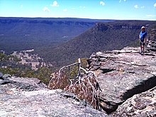
Geologically, the Blue Mountains are a sandstone plateau that is still visible today and into which rivers have dug deep valleys. They had been inhabited by Aborigines for at least 14,000 years ; Europeans have also settled them since 1813 . Around 1900 there was mining of various raw materials such as coal ; The area is now protected and used for tourism - especially from Katoomba and the Great Western Highway .
Geography and climate
The Blue Mountains are part of the Great Dividing Range and are located to the west and north of the Sydney metropolitan area . At the height of the Great Western Highway , it begins on the Nepean River at Penrith and has a diameter of about 50 km; further north it almost extends to the Pacific Ocean and has a diameter of 200 km. The northern limit is the Hunter Valley ; in the south, the Southern Highlands around Goulburn join the Blue Mountains. The Blue Mountains extend about 300 km from north to south.
In the central areas south and around Katoomba , the Blue Mountains are over 1,000 m high. A multitude of rivers have their source in the Blue Mountains, among them the Coxs River , which has its source north of Lithgow , but then crosses the Blue Mountains in the south and finally flows into the 40 km long Burragorang reservoir in the east, formed by the Warragamba Dam, which flows into the Nepean River drains away. This reservoir provides 70% of Sydney's water supply. The Colo River , which arises in the north of the Blue Mountains, and the Grose River , which has its source in the central Blue Mountains , drain into the same river, which is now called the Hawkesbury River . The multitude of smaller rivers in the west of the Blue Mountains flow into the Murray-Darling Basin .
The largest city within the range of the Blue Mountains is Katoomba. Other towns in the area are Hawkesbury , Lithgow and Oberon . The administrative district, the so-called City of Blue Mountains , has 73,675 inhabitants (2001 census).
There is a moderate climate ; temperatures vary between 0 and 3 ° C in winter; Snow rarely falls and the temperature rises up to 30 ° C in summer.
history
Aboriginal
The Blue Mountains had been inhabited by Aborigines for at least 14,000 years . At this time of the last Pleistocene it was colder than it is now; in winter the Blue Mountains were covered with snow. In caves and rock overhangs, which offered good protection, one therefore finds bones and stone tools as artifacts of their settlement. A find dated 22,000 years ago is controversial. It is also unclear whether the Blue Mountains were permanently inhabited or only at certain times of the year.
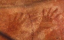
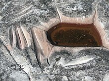
For bushfood Aboriginal this area were among the archaeological finds in accordance with kangaroos , wallabies , wombats , possums , dingoes , eggs, fish, reptiles, and the marrow of tree ferns and various fruits. As in other parts of Australia, there are petroglyphs , rock paintings with ocher and charcoal - here especially handprints - as well as grinding grooves in sandstone rocks that result from the grinding of the edges of stone axes or stone axes .
Initial attempts by the white settlers to cross the Blue Mountains led to reports that the mountains were almost uninhabited. It is unclear whether the Aborigines were hiding, living in other parts of the mountains, or were greatly reduced in number because of the smallpox epidemic in Australia in 1789 . The Blue Mountains are home to six language groups: Dharawal in the southeast, Gundungurra in the south; Wiradjuri in the west; Wanaruah in the far north, Darkinjung in the northeast and Darug in the east.
European settlement
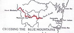
When the convict colony of Australia, founded in 1788, expanded from Sydney with the arrival of free settlers, the Blue Mountains soon presented an initially insurmountable barrier. Under Governor Lachlan Macquarie , the first expeditions began, which tried to cross the Blue Mountains to find more land To develop settlement. Based on the experiences of the first explorers who explored the area from 1793 - including George Bass among a number of unknown and forgotten ones - Gregory Blaxland , William Charles Wentworth and William Lawson were the first Europeans to cross the Blue Mountains in 1813 on the same route on which the Great Western Highway is today ( Blaxland Expedition ).
From 1814 the first road was built and the settlement of the Blue Mountains began. William Lawson was the first to drive cattle through the Blue Mountains in July 1814. In 1823, with the help of Aborigines , Archibald Bell found a second route through the Blue Mountains north of the Grose River - the Bell's Liner of Road; Settlement soon began along this route as well. Because of the impassable terrain, the settlement density remained very low.
Further development took place with the construction of a railway line that led from 1867 along the Great Western Highway to Mount Victoria and from 1876 reached as far as Bathurst . With this transport connection to Sydney, tourism began in the Blue Mountains: The first luxury hotels were built in the 1880s; numerous well-to-do citizens of Sydney built weekend homes in the mountains. At the same time, a number of hiking trails were set up. After 1900, cheaper accommodations appeared, so that Sydney's middle class also sought relaxation in the mountains.
Instead of raising livestock and grain as in other parts of New South Wales, another important economic factor in addition to tourism was the extraction of coal and oil in the 1880s to 1940s; however, the area was not as productive as the neighboring Hunter Valley , which is why the mines gradually closed. Remnants of the mines can still be seen today, especially around Lithgow and Katoomba.
World natural heritage
| Greater Blue Mountains World Heritage Area | |
|---|---|
|
UNESCO world heritage |
|

|
|
| Outline map of the Blue Mountains World Natural Heritage |
|
| National territory: | Australia |
| Type: | World natural heritage |
| Criteria : | |
| Reference No .: | [1] |
| UNESCO region : | Asia and Pacific |
| History of enrollment | |
| Enrollment: | 2000 (session 24) |
The beginnings of nature conservation in the Blue Mountains go back to 1880 when an area in Leura was declared a nature reserve. The driving force behind the establishment of the national parks was the hiker and conservationist Myles Dunphy, who submitted a proposal for a Greater Blue Mountains National Park as early as 1922 . In 1932, hikers from the Sydney Bush Walker's Club prevented the Grose Valley's Blue Gum Forrest from being chopped down and turned into a walnut plantation by buying up the forest.
In 1959, the Blue Mountains National Park was the first national park in the Blue Mountains to be established; When the Warragamba dam (Lake Burragorang), which ensures Sydney's drinking water supply, was completed in 1960, the catchment area was integrated into the national park. Other national parks followed, especially in the late 1960s and 1970s.
The so-called Greater Blue Mountains World Heritage Area , which has been included in the list of world natural heritage since 2000, comprises seven national parks and the Jenolan Caves Karst Conservation Reserve and thus covers a total area of 10,000 km².
Its inclusion as a world heritage site was justified by the abundance of species in eucalyptus , since 90 species and thus 13 percent of the species present worldwide are included in the world heritage site. In addition, the high proportion of endemic species (114) such as the Wollemia and a number of rare species led to this decision.
| National park / reserve | Location in the world natural heritage | view |
|---|---|---|
Blue Mountains National Park
Commons : Blue Mountains National Park - Collection of Pictures, Videos, and Audio Files
|

|

|
Gardens of Stone National Park
Commons : Gardens of Stone National Park - Collection of Images, Videos, and Audio Files
|

|
|
Kanangra Boyd National Park
Commons : Kanangra-Boyd National Park - Collection of Pictures, Videos and Audio Files
|

|

|
Nattai National Park
Commons : Nattai National Park - Collection of pictures, videos and audio files
|

|

|
Thirlmere Lakes National Park
Commons : Thirlmere Lakes National Park - Collection of pictures, videos, and audio files
|

|

|
Wollemi National Park
Commons : Wollemi National Park - Collection of images, videos and audio files
|

|

|
Yengo National Park
Commons : Yengo National Park - Collection of Pictures, Videos and Audio Files
|

|

|
Jenolan Caves
Commons : Jenolan Caves - collection of pictures, videos and audio files
|

|

|
Also in the Blue Mountains - but not a World Heritage Site - are Goulburn River National Park , Dharug National Park , Abercrombie River National Park and the Tarlo River National Park .
geology
The oldest rocks date from 470 to 330 million years ago, which corresponds to the Devonian and Carboniferous ages . At that time Australia was united with Antarctica to form Gondwana . These rocks were folded and broken; Granite is embedded in them. This layer belongs to the Lachland Fold Belt and is partially slightly metamorphic . These rocks are visible on the surface of the Coxs River , where they look like round boulders.
During the Permian and Triassic 290 to 230 million years ago, the area of what is now the Blue Mountains was part of the Sydney Basin , a geological sedimentary basin that formed at the bottom of a large freshwater lake. At the bottom of the sediment basin there is a layer that contains coal . Above are three layers of sandstone : the Narrabeen Group is at the bottom; they dominate the landscape of the western Blue Mountains. Above it was the Hawkesbury sandstone , which can be seen mainly in the east. Finally, the Wianamatta Group is on top: this layer is largely eroded and only exists in the central parts of the Blue Mountains. Overall, this sedimentary basin was up to 1000 m thick.
200 million years ago, the Sydney Basin erupted in several gas eruptions, with rock debris coming to the surface and solidifying over time. This rock is now eroded and has left several circular depressions in the north-west of the Blue Mountains.
The entire area of today's Blue Mountains was slowly raised above sea level about 70 million years ago and has since been exposed to erosion by rivers that have cut deep gorges into the plateaus over the course of millions of years and now offer wide views of the almost horizontal layers of the Offer sandstones .
The Blue Mountains Plateau now rises abruptly from the Cumberland Plain on the north-south running Lapstone Monocline from a height of 150 meters near Glenbrook to the Kurrajong Heights at 570 meters above sea level. The plateau is highest in the west.
Several volcanic eruptions took place 14 to 18 million years ago, leaving behind large areas of basalt that can still be found on the peaks of the mountains today.
Flora and fauna
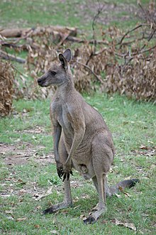
The animal world of the area includes 52 native and 13 introduced mammal species. Dominant among the larger species are various kangaroos, such as the eastern gray giant kangaroo ( Macropus giganteus ), the red-necked wallaby , the mountain kangaroo and the brush-tailed rock kangaroo . In addition, the marsupials are by Nacktnasenwombat , koala , tiger quoll , Riesengleitbeutler , the Middle petaurus ( Petaurus norfolcensis ), the Great petaurus ( Petaurus australis ), the Hundskusu ( Trichosurus caninus ) and potoroo ( Potorous tridactylus ) represented. Two species of monotremes, the platypus and the short-billed hedgehog, are found in the area. In addition, the reserve complex is home to 265 species of birds, 63 species of reptiles and 30 species of frogs.
The largest predator in the Blue Mountains is the dingo , a feral dog. A hunting method was recently observed on the Wollondilly River in the Blue Mountains, in which four dingoes drove a giant gray kangaroo into the water to kill it.
In a few humid places there are rainforests, otherwise eucalyptus dominates , of which there are 91 species. The eucalyptus forest is very susceptible to bush fires ; Large parts of the forest in the Blue Mountains regularly burn.
Known is the Wollemia ( Wollemia nobilis ), a primitive conifer , which is found only here and their discovery in 1994 as one of the most important botanical true finds of the 20th century.
tourism
Today the area can be traveled on routes with buses that stop at lookout points where tourists can get on and off at stops of their choice. In the vicinity of a viewing platform at Katoomba , the so-called Echo Point, in the immediate vicinity of The Three Sisters , there is the Scenic Skyway , a cable car that, when being transported from one high plateau to the other over a gorge , offers a view of the Three Sisters made possible.
The huge limestone cave system of the Jenolan Caves , the Zig Zag Railway , the first railway over the mountains built in the 1860s, as well as numerous waterfalls are worth seeing .
literature
- NSW National Parks & Wildlife Service: The Blue Mountains of Australia. 2005, ISBN 0-9589576-7-3 .
- NSW National Parks & Wildlife Service: The Greater Blue Mountains World Heritage Nomination (GBM-Nomination) (PDF; 5.9 MB), accessed October 14, 2010
- Department of Mineral Resources: Layers of Time. The Blue Mountains and their Geology. 1997, ISBN 0-7313-0274-5 .
- Department of Environment and Conservation: Northern Journeys Touring Guide. 2004, ISBN 0-7313-6765-0 .
Individual evidence
- ↑ GBM nomination, page 36
- ↑ GBM nomination, page 263
- ↑ a b GBM nomination, page 15. (English)
- ^ NSW National Parks & Wildlife Service, page 19
- ↑ UNESCO Steatement of Significance , accessed April 5, 2010
- ↑ a b c d e f g h NSW National Parks & Wildlife Service: The Greater Blue Mountains World Heritage Nomination (PDF; 5.9 MB), page 239. (English)
- ↑ Brad V. Purcell: A novel observation of dingoes ( Canis lupus dingo ) attacking a swimming eastern gray kangaroo ( Macropus giganteus ) . Australian Mammalogy 32 (2) 201-204, 2010. doi : 10.1071 / AM10001
Web links
- Entry on the UNESCO World Heritage Center website ( English and French ).
- Department of Environment, Heritage and the Arts
- The Blue Mountains World Heritage Institute
- Blue Mountains (English)
- Recordings of dingoes in the Blue Mountains on FLICKr Photo sharing


