Wet Tropics of Queensland
| Wet Tropics of Queensland | |
|---|---|
|
UNESCO world heritage |
|
| National territory: |
|
| Type: | nature |
| Criteria : | vii, viii, ix, x |
| Reference No .: | 486 |
| UNESCO region : | Asia and Pacific |
| History of enrollment | |
| Enrollment: | 1988 (session 12) |
The Wet Tropics of Queensland or, in English, the wet tropics of Queensland , are a natural region in northeast Australia, on the coast of the Great Barrier Reef . 8944.2 km² of which were declared a UNESCO World Heritage Site in 1988. This area, managed by the Queensland Parks and Wildlife Service , consists primarily of tropical rainforests , arguably most of the remaining Australian tropical rainforests .
history
The first humans came to the area and settled there at least 40,000 years ago. In 1770, James Cook and his crew discovered the Wet Tropics coast for Europe on the ship Endeavor . Cook took it with all of Eastern Australia for the British Crown . Back then, what is now the World Heritage area was one of the most densely populated areas in Australia. At that time, depending on the definition, either five to eight ( Nyawaygi , Wargamaygan , Djirbalngan , Yidinjdji , Djabuganjdji , Mbabaram , Kuku Yalanji , Gugu Badhun ) or about twenty Aboriginal tribes lived in it .
The exploration of the inland by Europeans did not begin until 1848 when Edmund Kennedy attempted to cross the Cape York Peninsula . However, he failed because he was killed by the residents. But he was followed by other explorers, including George Elphinstone Dalrymple in 1873 . These created the basis for the development of these areas by European settlers, ranchers and lumberjacks. The latter penetrated along the coast, where they particularly struck Toona australis , and in 1875 reached the Daintree and Mossman rivers. Mining began in the region around 1880 , to which gold discoveries , among other things, contributed. Around the same time, people began to cut down the lowland rainforests in order to plant sugar cane plantations on the land , which were later supplemented by planting bananas and other tropical fruits.
Mining, agriculture and forestry as well as fishing still form the economic basis of human life in the region. In the second half of the 20th century tourism was added, which is also of great importance today.
At the end of the 19th and beginning of the 20th century, the Aborigines were largely assigned to "reservations" set up for them. Converted to self-governing communities, these still exist in a certain way today and are now home to a large part of the indigenous population living in the region.
The region's two major cities were founded in 1864/1865 ( Townsville ) and 1876 ( Cairns ). Around half of all people who settle in and around the World Heritage area live in them. Most are descended from immigrants from the British Isles, but Italians, Germans, Dutch and Greeks, for example, also settled in the Wet Tropics. In 1988, the Wet Tropics of Queensland , and thus most of the tropical rainforests in Australia, were included in the natural heritage of mankind by UNESCO .
Geography and geology
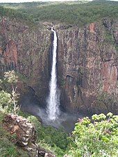
The Wet Tropics of Queensland mainly include mountainous coastal land, because they are located where the Great Australian Divide Mountains brush past the coast of the Coral Sea , which contains another World Heritage Site, the Great Barrier Reef . The highest mountain in Queensland , the 1622 m high Mount Bartle Frere , and the 278 m longest individual waterfall in Australia, the Wallaman Waterfall, are also within the boundaries of the World Heritage area .
Geomorphologically, the World Heritage area has a share in mainly three landscapes:
- the plateaus of the Great Scheidegebirge ,
- the Great Australian Alb and
- the coastal plain, which is quite narrow here.
Today the area of the Wet Tropics is geologically stable, but volcanoes were once active in it, of which the maars of the Atherton Tableland, among other things, still bear witness. On the coast there are numerous streams and rivers, which are mostly quite short because the mountains are so close to the sea. In the mountains there are also some creeks and rivers that initially flow west or south and cover a long distance before they flow into the sea on the east coast. Among them are some of Australia's richest rivers, such as the Burdekin River .
climate
As the name of the World Heritage area suggests, the Wet Tropics of Queensland are located in the humid tropics. Rainfall is abundant in the entire area (over 1200 mm / a), and Mount Bellenden Ker recorded the highest annual rainfall in all of Australia, over 9000 mm / a. Nevertheless, it does not rain evenly over the whole year, but up to two thirds of the precipitation falls in the southern summer (December – March). In contrast to many other tropical rainforests, a relatively large part of the precipitation runs off the surface in the wet tropics.
Since the Wet Tropics extend over very different altitudes, the local climate also differs greatly in its limits, especially with regard to temperature. For these the following applies approximately:
| coast | Mountain country | |||||||
| (Southern) summer | 23-31 ° C | 17-28 ° C | ||||||
| (Southern) winter | 18-26 ° C | 9-22 ° C |
Vegetation and biodiversity
In keeping with the climate, the World Heritage area is dominated by tropical rainforests , most of Australia and some of the oldest in the world. These tropical rainforests are divided into 13 structurally different types, but ecologically and climatically one can mainly differentiate between mountain and lowland rainforests. The mountain rainforests are still largely preserved and even spread after the end of their use by the local population and the resulting reduction in the frequency of fire. In contrast, a large part of the lowland rainforests was cut down in order to use the land for agriculture. Other types of natural vegetation that are significant in terms of area in the World Heritage Area are mainly dry forest , tree savannahs , swamps and mangroves .
The Wet Tropics are one of the areas in Australia with the highest biodiversity. Here you can find (in brackets the taxa endemic to the area are given):
| Organism group | Familys | Genera | species |
|---|---|---|---|
| higher plants | 119 | 523 (43 endemic) | 1161 (500 endemic) |
| be crazy | ? | ? | > 300 |
| Insects | ? | ? | > 5000 |
| Amphibian (frog ~) | ? | ? | 47 (20 endemic) |
| Reptiles | ? | ? | 160 (approx. 16 endemic) |
| Birds | ? | ? | > 370 (13 endemic) |
| Mammals: monotremes | 2 | 2 | 2 |
| Mammals: Marsupials | ? | ? | 37 (8 endemic) |
| Mammals: rodents | ? | ? | 16 (1 endemic) |
| Mammals: bats | ? | ? | 34 |
Also among the plants and animals that make up the Wet Tropics are numerous in some respects unusual or notable species, including
- two types of tree kangaroos : Lumholtz tree kangaroo ( Dendrolagus lumholtzi ) and Bennett tree kangaroo ( Dendrolagus bennettianus ),
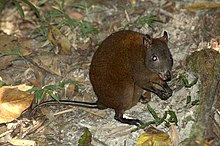
- the primitive musk rat kangaroo ( Hypsiprymnodon moschatus ),
- the Lemur Ringbeutler ( Hemibelideus lemuroides )
- the flightless cassowary ( Casuarius casuarius ), one of the largest birds in the world,
- the Black Breast Reifelvogel ( Ptilorus victoriae ),
- the silky bowerbird ( Ptilonorhynchus violaceous ),
- two more widespread species of large foot fowl (Megapodiidae), which hatch their eggs in sometimes huge 'compost heaps',
- Leaf- tailed geckos ( Phyllurus spp.) difficult to distinguish from bark .
Many of the organisms are more closely related to South American than to Asian species, which is due to the fact that their ancestors (more than 60 million years ago) populated the primary continent Gondwana , in which Australia, Antarctica (Nota) and South America were united (to earlier Times also India, Africa, Madagascar ...). Other species, however, descend from forms which only recently came to Australia from Asia (probably less than 20 million years ago). Most of the fish and crustaceans that live in the waters of the area are descendants of marine life.
Protected areas
There are many protected areas in the Wet Tropics of Queensland, including the following national parks:
- Barron Gorge National Park
- Black Mountain National Park (Queensland)
- Cedar Bay National Park
- Daintree National Park
- Edmund Kennedy National Park
- Girringun National Park
- Kirrama National Park
- Kuranda National Park
- Wooroonooran National Park
swell
- UNEP World Conservation Monitoring Center - http://www.wcmc.org.uk/protected_areas/data/wh/wettropi.html
Web links
- Entry on the UNESCO World Heritage Center website ( English and French ).
- Wet Tropics Management Authority (Protected Area Management - further information & details )
- Environment Protection Agency & Queensland National Park & Wildlife Service: Wet Tropics of Queensland WHA (brief description )
- Environment Australia: Wet Tropics of Queensland WHA (Description & Links )
Coordinates: 17 ° 30 ′ 0 ″ S , 145 ° 45 ′ 0 ″ E


