
Fraser Island
| Fraser Island ( K'gari ) | |
|---|---|
 |
|
| Waters | Coral sea |
| Geographical location | 25 ° 13 ′ S , 153 ° 8 ′ E |
 |
|
| length | 124 km |
| width | 25 km |
| surface | 1 840 km² |
| Highest elevation | Boomerang Hill 260 m |
| Residents | 182 (2016) <1 inh / km² |
| main place | Eurong |
Fraser Island (rarely also Fraser Island , formerly Great Sandy Island ) is an island belonging to the administrative area Fraser Coast Region in the Australian state of Queensland . With an area of 1840 square kilometers, it is the largest sand island in the world. It is located about 190 kilometers north of Brisbane off the east coast of Australia. In the Aboriginal language it is called K'gari , which means "paradise". The island has been a UNESCO World Heritage Site since 1992 .
geography
Fraser Island is 124 kilometers long, an average of 15 kilometers wide and covers 1840 square kilometers (in comparison: Rügen is about half the size). In the south-west is the 70-kilometer-long Great Sandy Strait , a strait , and in the north-west, the Hervey Bay. To the east, Fraser Island borders the South Pacific. The highest dune on the island is Mount Bowarrady , which is about 240 meters high . The touristic island is part of the Great Sandy National Park nature reserve .

There are almost 200 freshwater lakes (e.g. Lake McKenzie , Lake Boomanjin ) of various types on Fraser Island , which have extremely clean and clear water. Parts of the lakes are those in a layer of floating groundwater : water that lies over a waterproof layer of coffee rock (a compressed material made up of sand and organic components). The other lakes on Fraser Island were formed either when sand dunes blocked waterways or when a depression released underlying groundwater. The Lake Wabby is spilling over the next millennia of a sand dune.
75 Mile Beach is located on the east coast of the island . It is an official highway, can be driven on by four-wheel drive vehicles and also serves as an airport for small aircraft.
According to the 2011 census, only four Aborigines live on Fraser Island out of a total population of 182.
geology
Except for some rock forms of volcanic origin, for example rhyolite rock in Indian Head in the northeast of the island, Fraser Island consists of sand. This sand is a product of erosion from the Great Dividing Range , the mountain range that runs along the entire east coast of Australia. It was transported to the sea by the river systems of northern New South Wales and from there northwards by the prevailing southeast trade winds and ocean currents along the coast.
Until 10,000 years ago, Fraser Island was part of the mainland. The end of the Australian continental shelf ran about 25 kilometers off today's east coast of the island. Hervey Bay, west of what is now the island, was dry land; at the hollow on what is now Big Woody Island , the Mary River was diverted to the southeast and drained into what is now the Great Sandy Strait , an estuary. The Mary River and its tributaries dug deep valleys into the landscape at that time. After the last ice age, the sea level rose by up to 120 meters. In this slow process, the Aborigines were forced to follow the changes in their habitat. The Mary River with its tributaries formed wide, flat, sandy estuaries that were flooded by salt water.
But winds also drove the deposited sand, which stuck to some protruding rock outcrops and elevations. The sand built up to form dunes and was initially stabilized by colonization of sand plants. Over the millennia, new dunes raised and reshaped the land. This land formation process continues to this day.
structure
Together with a few minor islands off the southwest coast such as Slain, Tooth, Roundbush, Moonboom, Gardner, Dream, Stewart Island, and the Reef Islands, which are part of the southern Parish Talboor, Fraser Island forms the County of Fraser , one of 322 cadastral districts of Queensland. County of Fraser is divided into six parishes :
![]() Map with all coordinates: OSM | WikiMap
Map with all coordinates: OSM | WikiMap
|


history
Aborigines of the Butchulla
Archaeological finds have shown that Fraser Island has been inhabited by the Butchulla , an Aboriginal tribe , for at least 5500 years . It is believed that the island was settled 40,000 years ago. In early European travel reports a very dense population of 2,000 to 3,000 inhabitants is described. According to the scientists, however, a permanent population of only 400–600 indigenous people can be assumed, which, however, fluctuated very strongly with the seasons. The main reason for this was probably the rich offer of seafood during the winter months: mussels, turtles, fish, dugong and birds were just as much a part of the food as berries, honey, Bungwall fern roots and the nectar of the banksia ( Banksia ).
In 1897, Protector of Aborigines Archibald Meston established an Aboriginal missionary station in the old quarantine station at White Cliffs on the west coast, which housed 61 Aborigines from the island and the mainland. Their number rose to 147 by 1901, after which the mission station was relocated to an area about 15 kilometers further north. The conditions in the Bogimbah mission station mentioned by the Butchulla were inhumane. The death rate was high: half of those housed there died of disease and malnutrition. There was also a plague of mosquitoes and sand flies in the area . In 1904 the station was abandoned and the survivors were deported to the mission station at Yarrabah , about 50 kilometers north of Cairns on the mainland. At the end of 2014, members of the Butchulla uncovered two cemeteries at the former branches of the mission station with a total of 70 graves.
On October 24, 2014, the Butchulla Aboriginal Corporation RNTBC , which represents the land rights of the Butchulla, was awarded a native title in court .
Dream time
In the dream time of the Butchulla, the role of the female being K'gari in particular is portrayed differently in slight variations.
K'gari is a ghost. The creator of the world, Beeral , sent two messengers who were charged with transforming the rough earth into a paradise. The male being Yindingie and the female being K'gari created an earthly paradise. In one representation, K'gari fell asleep exhausted in a bay, whereupon Yindingie transformed her body into the elongated island. While she slept, he dressed her in the rainforests and painted her body in the colors of the rainbow, giving her eyes the shine and glitter of the lakes on the island. He decorated the sky above her with wonderful birds. So that she would not be left alone, he gave the island to the Butchulla.
In another story, K'gari woke up after sleep and asked Yindingie to be allowed to stay on earth since she had arrived in paradise. Since she was a spirit, so Yindingie, he had to objectify so that she could stay on earth and created Frazer Island out of her body.
The colored sand dunes are the spiritual center of the Butchulla .
First contacts with Europeans
At Hood Point on Fraser Island, objects made of lead were found that had been mined in Spain according to a material analysis. It is believed to be from the expedition of the Portuguese conqueror Cristóvão de Mendonça from 1521 to 1522. There is no written evidence of this assumption, as the Mendonça documents were burned in Lisbon.
Two clay pipes were found in a shell collection near Indian Head . Based on their shape, it can be concluded that they may have been made in the 17th century and by Dutch sailors. To what extent there were contacts with Aborigines remains uncertain.
James Cook sighted Fraser Island on Endeavor as he sailed north about five nautical miles away. Through his telescope he saw several people on the Indian Head headland and noted this in his logbook .
When Matthew Flinders was sailing along the east coast of Australia at night in 1799, he saw several fires on the Fraser Island shoreline. On his second voyage from 1802 to 1803, he circumnavigated the entire continent of Australia . He landed with the HMS Investigator near Sandy Cape . Flinders Bungaree , an Aboriginal from the Port Jackson area , served as interpreter on board . This was the first written contact between the indigenous population and Europeans on Fraser Island.
Island name
A shipwreck in the 19th century led to the island being renamed. In 1836, the ship broke Stirling Castle under Captain James Fraser of Sydney with the aim Singapore on. On the Great Barrier Reef , the hull of the ship was damaged on May 21, 1836 and the ship sank. The surviving castaways, including Captain Fraser and his wife Eliza, rowed towards the Moreton Bay convict colony . Eliza is said to have been heavily pregnant and gave birth to her child on a lifeboat, who died a short time later. A lifeboat with the Frasers finally landed on what was then called Great Sandy Island . Some of the shipwrecked died while waiting for several months to be rescued from the island. Eliza Fraser and other sailors survived thanks to the help of the indigenous people. Eliza later testified that her husband was killed by an Aboriginal spear.
Eliza was later saved. In Sydney and then in England she pretended to be an impoverished widow, even though she had married Captain Alexander John Greene on February 3, 1837. Eliza reported in front of an audience and in newspapers about the alleged cruelty, brutality and savagery of the Aborigines and earned money with it. Although their stories were doubted and refuted by many, the effect for the Australian natives was fatal, because many settlers were influenced by it in their behavior towards the Aborigines. Eliza is portrayed in literature as a contradicting personality. It is true, however, that many of the Aborigines who had helped her in her struggle for survival were killed in massacres by Europeans.
The island got its current name after Captain Fraser. The story of the Frasers prompted artist Sidney Nolan to travel to Fraser Island and inspired a number of paintings. Even his friend, the Australian writer and Nobel Prize for Literature carrier Patrick White , was the island on his 1976 novel A Fringe of Leaves excited in which he retold Eliza's history. Fraser Island also serves as the setting in his novel The Eye of the Storm .
In addition to the name Fraser Island, K'gari , the traditional name of the Aborigines , is also increasingly being written.
Industrial use
The first whites settled on Fraser Island in the 1840s. The refuge for the Butchulla Aborigines was soon changed by clearing for pastures and logging: from 1863, lumberjacks began to use the island as a wood reservoir. Timber trading was the main source of income on the island for more than 100 years. Large areas were cut down to obtain the precious Satinay pines ( Syncarpia hillii ). Satinay pines only grow on Fraser Island and two neighboring islands. The wood of this tree species is resistant to water thanks to an oil it contains. For this reason it was used in shipbuilding and, for example, in the construction of the Suez Canal .
Before the arrival of the Europeans, the cultural center of the Butchulla on the island was the clearing on Wanggoolba Creek, now known as the “Central Station”. It was an area reserved for women where births took place. During the period of industrial logging, Central Station was the headquarters of the loggers from 1920 to the late 1950s, and a school was even built for their children. Today it is a picnic area with many display boards about the nature and history of Fraser Island, and also the starting point for an educational forest trail along Wanggoolba Creek, with many types of rainforest trees and giant ferns.
The industrial mining of wood lasted until 1991, when the as yet unprotected parts of the island were declared a nature reserve and part of the Great Sandy National Park.
When drilling for oil on Fraser Island in the 1960s, valuable and rare minerals such as rutile , zircon , monazite and ilmenite were discovered in the sand . Industrial dismantling began in 1966 and was intensified considerably in December 1974 by a decision by the government of Gough Whitlam . As a result of this decision, two hectares of land near Dilli Village on the island were mined daily for 80 days . A mining ban in the affected area could only be fought for in 1975 before the highest court in Australia through a judgment of last instance. However, it was not until 1991 that the Queensland government imposed a sand mining ban on the entire island, presumably to promote the entry of Fraser Island on the UNESCO World Heritage List, which took place in 1992.
Wreck of the Maheno
_IGP4364.jpg)
In 1935, the former luxury liner SS Maheno ran aground on the east coast of the island during a cyclone that was untypical for the season . The Maheno was to be scrapped in Japan and was pulled by a smaller ship. In order to reduce the flow resistance, the Maheno screws and rudders had been removed, so that it could no longer maneuver itself in the storm. Attempts to get rid of the stranded ship failed. In the first years the Maheno was used by the island's residents for weddings and celebrations, among other things. It later served as a target for the Royal Australian Air Force (RAAF). Today only the upper decks of the ship are visible.
Military use
In World War II, two military camps that were on Fraser Iceland built, Fraser Commando School , about 20 kilometers from Lake McKenzie away, and another in the immediate vicinity of the lake. The Fraser Commando School served to prepare several thousand soldiers for combat on the Pacific Islands, as Fraser Island has similar conditions. But military specialists were also trained in communication and secret service tasks, weather forecasting and medical services.
Paratroopers were trained at Lake McKenzie, and explosive training took place on the Maheno wreck.
Flora and fauna

There are a wide variety of habitats on Fraser Island. These include mangrove swamps , bushland and eucalyptus forests. There are also sand dunes that are covered with tropical rainforest - the flora and fauna are correspondingly rich. The diversity of plants despite the sandy soils can be explained by mycorrhiza , as the fungal mycelium of the island dissolves nutrient salts from the sands and makes them available to the plants.
Fraser Island is home to more than 350 species of birds, including the Australian oystercatcher and tern , as well as around 40 species of mammals . There are soldier crabs on the coast and many rare or endangered species such as dolphins , sea turtles , humpback whales and the dugong in the coastal waters . The freshwater lakes in the interior of the island are home to many species of fish and freshwater turtles.
A tourist attraction is the dingo ( Canis lupus dingo ). According to current estimates, around 300 animals live on the island. The dingo has mixed heavily with other dog breeds in many areas of Australia and is usually no longer considered purebred. The geographical location makes Fraser Island one of the last retreats of the original dingo (at least according to DNA studies from 2004), but skull examinations in the 1990s came to a different conclusion. Unfortunately - mostly due to human error - there are always incidents that end in injuries and sometimes fatal for people (the death of a child is well known). In the majority of cases, however, the incidents are fatal for the dingoes. The dingo population is therefore under considerable pressure to survive in this national park.
World natural heritage and national park
Part of the island, 74,900 hectares, has been protected as a national park since 1971. In 1992 the island was declared a World Heritage Site. It was selected as an exceptional example of ecological and biological processes as well as a gigantic natural phenomenon and thus fulfilled two of the four criteria at the time.
transport

Fraser Island is connected to the mainland by car and passenger ferries from River Heads at Hervey Bay and to the south from Inskip Point at Rainbow Beach, which dock at Wanggoolba Creek, Kingfisher Bay and Hook Point. Bus tours booked on Fraser Island start with a ferry crossing from the ports of Hervey Bay, Rainbow Beach and Noosa. All connecting roads on the island are sand tracks with a maximum speed of 30 km / h. The long sandy beach on the east coast is used both as a driveway (maximum speed limit 80 km / h) and as an airstrip ( Air Fraser from Hervey Bay and Maroochydore) at low tide .
tourism
Particularly worth seeing are the colorful sand and sandstone formations (“The Pinnacles”, “The Cathedrals”), the sand dunes by the sea and some of the many freshwater lakes. Lake McKenzie is very popular because of its location near the main slopes, because of the white sand and blue water. The water is extremely clear and, according to a study in 2010, is of drinking water quality. The short freshwater stream Eli Creek is popular for wading, at its mouth there is a lagoon for bathing. A problem for all lakes and Eli Creek is pollution from sunscreens and other cosmetic products, which has increased in recent years. Local environmental groups are therefore calling for the lakes on Fraser Island to be closed to bathing.
There are a few hotels - such as Kingfisher Bay and Eurong -, many camping options and the Happy Valley holiday colony . Car trips along the east side of the beach (the island's highway known as "75 Mile Beach") and along the inland sand roads are particularly popular. Small planes for island sightseeing flights also take off from this sandy beach. Only four-wheel drive vehicles are allowed on the island and can be rented in Brisbane, Hervey Bay or Rainbow Beach, with full camping equipment if desired.
Bathing in the sea is life-threatening, as treacherous currents prevail, especially on the east coast, the waters get deep very quickly and sharks can be found in the waters .
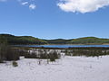
Lake McKenzie Beach

Lake McKenzie Beach

Lake McKenzie
Driving on a sand track on Fraser Island
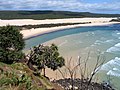
View from Indian Head to the northwest


Web links
- Department of National Parks, Recreation, Sport and Racing (English)
- Side of the Australian government to Fraser Iceland (English)
- Fraser-Island.de (German)
- Map in Lonely Planet
- http://www.fraserisland.net/
- Entry on the UNESCO World Heritage Center website ( English and French ).
Individual evidence
- ^ Australian Bureau of Statistics : Fraser Island ( English ) In: 2016 Census QuickStats . June 27, 2017. Retrieved April 7, 2020.
- ↑ a b c A History of Aboriginals of Fraser Island , at fido.org.au. Retrieved April 25, 2016
- ↑ [1]
- ↑ Capturing the cultural heritage of an Australian paradise island. In: Fauna & Flora International. December 5, 2014, accessed April 26, 2016 .
- ↑ Butchulla Aboriginal Corporation RNTBC. (PDF) In: Prescribed Bodies Corporate :. December 1, 2014, archived from the original on March 3, 2016 ; accessed on April 26, 2016 (English).
- ^ Fraser Island - Aboriginal History & Legends (part 2). In: emeraldene.com.au. November 15, 2013, accessed April 14, 2019 .
- ↑ Rob Lennon: Fraser Island - Aboriginal History & Legends (part 2) , November 15, 2013, on emeraldene.com.au. Retrieved May 5, 2016
- ↑ Elaine Brown: Fraser, Eliza Anne (1798-1858). In: adb.edu.au. Retrieved April 26, 2016 .
- ↑ a b Nature, Culture and History. In: Fraser Island, Great Sandy National Park. Department of National Parks, Sport and Racing, April 11, 2016, accessed April 26, 2016 .
- ^ A History of FIDO and its Campaigns Fraser Island Defenders Organization — The Watchdog of FraserIsland , at fido.org.au. Retrieved May 20, 2016
- ↑ Mystery shrouds claim the army has Fraser in its sights. In: frasercoastchrincale.com. July 16, 2016, accessed April 24, 2016 .
- ↑ Twice as many things on Fraser Island than previously thought
- ^ Jonica Newby: Last Of The Dingoes. ABC, March 31, 2005, accessed May 8, 2009 .
- ^ PF Woodall, P. Pavlov, KL Twyford: Dingoes in Queensland, Australia: skull dimensions and the indenity of wild canids. CSIRO Publishing, 1996, accessed May 8, 2009 .
- ^ Nine-year-old boy killed by dingoes on holiday island beach. Daily Mail, 2001, accessed October 11, 2013 .
- ↑ WCMC / IUCN: Advisory Body Evaluation. (PDF) World Heritage Nomination - IUCN Summary; 630: Fraser Island and the Great Sand Region (Australia). In: UNESCO. March 1992, p. 23 , accessed on April 29, 2016 (English).
- ^ Fraser Island Station. (PDF) In: Queensland Police. Retrieved September 3, 2016 .
- ^ Environmental Protection (Water) Policy 2009. Fraser Island environmental values and water quality objectives Basin No. 139 , from July 2010, on ehp.qld.gov.au. Retrieved April 26, 2016

![[1]](https://gisservices.information.qld.gov.au/arcgis/rest/directories/historicalscans/cad_scans/cad-map-2mile-county-march-sh1-1922.jpg)
Heritage: Royal Exhibition Building and Carlton Gardens (2004) | Sydney Opera House (2007) | Australian Prison Camps (2010) | Budj Bim cultural landscape (2019)
Natural Heritage: Great Barrier Reef (1981) | Lord Howe Archipelago (1982) | Gondwana Rainforests of Australia (1986) | Wet Tropics in Queensland (1988) | Shark Bay (1991) | Fraser Island (1992) | Riversleigh and Naracoorte Fossil Sites (1994) | Heard and McDonald Islands (1997) | Macquarie Island (1997) | Greater Blue Mountains Area (2000) | Purnululu National Park (2003) | Ningaloo Coast (2011)
Cultural / Natural Heritage: Kakadu National Park (1981) | Willandra Lake Region (1981) | Tasmanian Wilderness (1982) | Uluṟu Kata Tjuṯa National Park (1987)