Sturt National Park
| Sturt National Park | ||
|---|---|---|
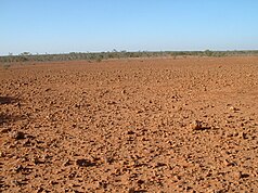
| Hard, stony desert soil ( Gibber plains ) in Sturt National Park | ||
|
|
||
| Location: | New South Wales , Australia | |
| Specialty: | Stone and sand desert, table mountains | |
| Next city: | Tibooburra | |
| Surface: | 3,106.34 km² | |
| Founding: | February 25, 1972 | |
| "Jump-Up-Country" at Olive Downs Station | ||
| Blooming desert in Sturt National Park after the rain | ||
The Sturt National Park is a national park in the extreme, dry northwest of the Australian state of New South Wales , 1059 km northwest of Sydney . Established in 1972, the park was named after the discoverer Charles Sturt . It covers 340,000 hectares, making it one of the largest national parks in New South Wales. In the park you can observe the typical outback scenery with flat, red-brown landscapes. The national park was created from five sheep farms. Sturt National Park was mentioned in the British television documentary Planet Earth . The dingo fence runs along the northern boundary of the park.
Flora and fauna
Large populations of the red giant kangaroo and the western gray giant kangaroo can be found in the park . The vegetation consists mainly of mulga bushes and dry bushland. After prolonged rain, the rough landscape is completely transformed by the sprouting of wildflowers, such as B. the pea ( Sturt's Desert Pea , Swainsona formosa ).
Attractions
In the park you can find Køkkenmøddinger and Aboriginal stone relics . There are many hiking trails and an extensive road network. Most of the roads in the park are unpaved and gravel, with some stretches on sand. All can be driven on with conventional road vehicles. A four-wheel drive vehicle is only needed after heavy rainfall .
In the east of the park are floodplains that are peppered with individual trees. They then give way to small, rocky canyons and stream beds. This is where the Mount Wood and Gorge Lookout viewpoints and the Mount Wood campground are located .
In the center of the park you will find The Olive Downs - also called "jump-up-country" - that with flachgipfligen mesas rise, the m up to 150 over the surrounding plains, granite - outcrops and shallow valleys comes up. The "jump-ups" are remnants of an old mountain range. This is where the park's second campsite, the Dead Horse Gully, is located . There is another campsite between the boulders north of Tibooburra . All campsites have toilets, gas stoves and water connections.
In the far west of the national park, the sand dunes of the Strzelecki desert replace the hard desert soil. The Cameron Corner (point where the states of New South Wales, Queensland and South Australia meet) is a remote but popular spot for tourists. Nearby is the park's fourth campground, Fort Gray , and a site of historical interest: the farms and remains of the explorer Charles Sturt. The fort consists of palisades that were supposed to keep Sturt's supplies and prevent the expedition's sheep from running away. In search of the legendary inland sea , Captain Sturt, after which the park was named, spent a year in the area.
photos
Dingo fence at Cameron Corner
Western gray kangaroos in the national park
Web links
Individual evidence
- ↑ a b c d Chris Pritchard: Corner Country's where three states meet and tourists roam . Courrier Mail (December 7, 2008). Queensland Newspapers
- ↑ a b c d Tibooburra , website Traveler, accessed on June 23, 2017
- ^ Sturt National Park Travel Information and Travel Guide . Lonely Planet Publications. February 17, 2009 ( Memento of the original from January 24, 2009 in the Internet Archive ) Info: The archive link was inserted automatically and has not yet been checked. Please check the original and archive link according to the instructions and then remove this notice.
- ↑ Photo community . Wolfgang Koelln. Retrieved November 7, 2012.
- ↑ a b c d e f g Discover Australia's National Parks . Hema Maps. Random House Australia. Milsons Point NSW (1997). ISBN 978-1875992478 , pp. 128-129


