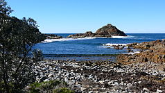
Mimosa Rocks National Park
| Mimosa Rocks National Park | ||
|---|---|---|
| Aragannu in Mimosa Rocks National Park | ||
|
|
||
| Location: | New South Wales , Australia | |
| Specialty: | Rocky coast | |
| Surface: | 57 km² | |
| Founding: | April 13, 1973 | |
The Mimosa Rocks National Park is a national park in the southeast of the Australian state of New South Wales , 329 km south of Sydney between the cities of Tathra and Bermagui .
The area was declared a national park on April 13, 1973. Most recently, an area of 105 hectares was added in 1999, which was separated from the Murrah Garden Estate and contains the coastal sections Bunga Beach and Goalen Head . The Bournda National Park connects to the south.
The park begins at the north end of Tathra Beach and extends north about 10 miles from there. There are five entrances from the Tathra – Bermagui road.
In Mimosa Rocks National Park, there are four campsites, Gillard , Middle Beach , Aragannu and Picnic Point . All tent sites are equipped with barbecue grills and dry toilets.

