Warrumbungle National Park
| Warrumbungle National Park | ||
|---|---|---|
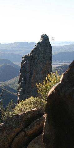
| The basalt breadknife rock | ||
|
|
||
| Location: | New South Wales , Australia | |
| Specialty: | Basalt rocks, light protection area | |
| Next city: | 24 km west of Coonabarabran | |
| Surface: | 236 km² | |
| Founding: | 1967 | |
The Warrumbungle National Park (English Warrumbungle National Park ) is located in the state of New South Wales , Australia , 450 kilometers northwest of Sydney . The city of Coonabarabran is located near the park . From there, a 35-kilometer paved road, the John Renshaw Parkway , leads directly into the park. The name of the park Warrumbungle comes from the Aborigines and means crooked mountains . The park was established in 1953 and covers an area of 236.21 square kilometers. On July 12, 2006, it was added to the National Heritage List . Since 2016 it has also been recognized as an International Dark Sky Park .
Geology, flora, fauna
The park features a series of bizarre basalt rocks . The most popular is the so-called Bread Knife (bread knife), which protrudes with a thickness of two to six meters 90 meters vertically upwards. This rock spire and other rock towers show that 13 million years ago glowing lava penetrated into the cracks and crevices of a rock formation made of sandstone and cooled down. Erosion and weathering processes eroded the soft rock over the millions of years and the hard basalt rock resisted. Numerous minerals such as quartz and petrified fossils can be found in the park . The Crystal Kingdom mineral exhibition is located in Coonabarabran and is run by a German-Australian.
The park's native mammal species include koalas , short-billed hedgehogs , fox kusus , giant gliding sacs and five species of kangaroo . The eastern gray giant kangaroo is particularly common , while the brush-tailed rock kangaroo has become very rare due to competition from feral goats. The three other types of kangaroo are red-necked wallaby , swamp wallaby and mountain kangaroo . There are also numerous species of birds and reptiles. More than 600 plant species were counted. There are several well-developed hiking trails and climbing opportunities in the park.
In January 2013, bushfires devastated large areas in and around the park.
Facilities and light protection
There are rest areas and a campsite in the park.
At the edge of the park is on Mount Woorut ( 1156 m ), the largest star observatory in Australia, the Siding Spring Observatory . There is a light protection area for this observatory , the only one in Australia so far (as of early 2019). It was recognized by the International Dark Sky Association as an International Dark Sky Place in 2016 , is listed as a Dark Sky Park , and has been awarded the gold rating , the highest quality level for nighttime darkness. The light protection area covers 23,460 hectares.
Web links
- Official website of Warrumbungle National Park , on the website of the NSW National Parks and Wildlife Service (nationalparks.nsw.gov.au, Engl.)
- City map of Coonabarabran
- Stargazing in the Warumbungles. (on visitnsw.com).
Individual evidence
- ↑ Huge wildfire tears through Australian national park. In: itv. January 18, 2013, accessed on January 26, 2013 (English): “A huge wildfire has swept through the Warrumbungle National Park in Australia's New South Wales. The enormous blaze, described as one of the most ferocious experienced in recent years, has destroyed around 40,000 hectares of land, dozens of homes, livestock and wildlife. "
- ↑ Dark Sky Parks. NSW National Parks and Wildlife Service, nationalparks.nsw.gov.au.
- ^ Warrumbungle National Park (Australia). , darksky.org.

