Scotland Island
| Scotland Island | ||
|---|---|---|
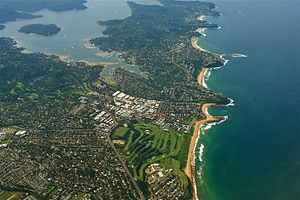
| Aerial view of the northern coasts of Sydney, Pittwater and Scotland Island at the top left | ||
| Waters | Pittwater | |
| Geographical location | 33 ° 38 '25 " S , 151 ° 17' 26" O | |
|
|
||
| length | 950 m | |
| width | 870 m | |
| surface | 52 ha | |
| Highest elevation | 120 m | |
| Residents | 642 (2006) 1235 inhabitants / km² |
|
| main place | Scotland Island | |
Scotland Island is an island in north Sydney in New South Wales , Australia . The island is in the area of Church Point , a suburb of Sydney, 33 km north of downtown Sydney in the constituency of Pittwater Council at the end of Pittwater .
Geography and Geology
The diameter of the island is almost a kilometer, with an area of 52 hectares and it rises 120 meters above sea level. To the east of the island are Newport , to the west of the Ku-ring-gai-Chase National Park , to the south of Church Point and Viewbay . The island is surrounded by small beaches, which mainly consist of clay and rocky subsoil and are overgrown by mangroves . There are no rivers or cliffs on the island, but there are small rock hollows in the sandstone layer on top .
About 18,000 years ago, Scotland Island was a hill on the edge of a river valley in the Sydney Basin . When the sea level rose after an ice age, the valley was filled with water and the island of Scotland Island in the Ria Pittwater emerged from a former hill . The island is of Sydney sandstone covered and underneath the layers of lie slate of Narrabeen Group .
There are five green spaces on the island. The largest are Elizabeth Park (6.8 hectares) in the center and Catherine Park (0.78 hectares) in the north, followed by Leahvera Reserve (0.58 hectares, west), Pathilda Reserve (0.4 hectares, east), and Harold Reserve (0.2 hectares, south).
history
Europeans made their first expedition to the island area in March 1788, shortly after establishing a penal colony at Sydney Cove , and when the penal colony's first governor, Arthur Phillip , saw the water, he exclaimed: “The finest piece of Water I ever saw ”(German:“ the best water I have ever seen ”), gave the names Pitt Water and Pitt Island after the British Prime Minister William Pitt Pitt Island .
The first European settler was the convict Andrew Thompson, who received 52 hectares of land on the island for his rescue services when the Hawkesbury River was flooded . He successfully built up a salt production facility there and named the island after his home country Scotland Island , later he became administrator and overseer of the British convicts, ship registrar on the Hawkesbury River, judge and shipbuilder and died in 1810.
The island was sold as a whole a few times in the 19th century before being offered in 121 plots in 1906 and 1911, and again in 1924, this time in 361 plots. The sale was difficult and no permanent buildings were built. Permanent branches emerged in the 1960s and the island developed from 1967 when sheep was farmed on the island.
Island community
Scotland Island is one of the two inhabited islands in the Sydney area and had a population of 642 in 2006. The island is served by the Church Point Ferry , a ship ferry and private boats. Most of the island is made up of bushland with around 350 buildings stretching along the island's coastline. There are no commercial shops, cafes or industrial areas on the island. The children's center and the community hall were built by the islanders in the 1980s and 1990s and are used for different purposes. The Island Thinkers organizes discussion and artistic events and in 2006 an arts and film festival was organized on the island by this community. A newspaper is published on the island.
The majority of the islanders work on the mainland. Life on the island is arduous, the plots are on steep terrain, electrification took place in 1960, most islanders have to walk because there is no road connection to the mainland, so there are few cars on the island and a transfer takes place with a ferry which has been in service since 1950. The island's rubbish has to be removed by ship and in 1967 the islanders voted against the supply of urban water and continued to supply themselves with rainwater. Since 1980 there have been four small port facilities where water taxis and boats can dock. Due to the lack of road links to the mainland, a volunteer fire brigade is on duty on the island, for which the Sydney fire brigade would otherwise be responsible.
Individual evidence
- ↑ a b c d e Virginia Macleod Scotland Island at www.dictionaryofsydney.org . Retrieved January 3, 2011
- ↑ Information about parks at www.pittwater.nsw.gov.au . Retrieved January 4, 2010
- ↑ Environmental information on www.pittwater.nsw.gov.au . Retrieved January 4, 2010
- ^ Australian Bureau of Statistics

