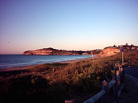
Mona Vale (Sydney)
| Mona Vale | |||||||
|---|---|---|---|---|---|---|---|
 Mona Vale Beach |
|||||||
|
|||||||
|
|||||||
|
|||||||
|
|||||||
|
|
|||||||
Mona Vale is a suburb in northern Sydney in New South Wales , Australia . Mona Vale is 28 kilometers north of the city center and has been the administrative seat of the Administrative Area (LGA) Pittwater Council since 2005 .
The area was known to the Aborigines as Bongin Bongin . The first land in the Pittwater District was granted on April 23, 1813. The area that today includes Mona Vale went to Robert Campbell (1769–1846).
Web links
Commons : Mona Vale - collection of images, videos and audio files
Individual evidence
- ↑ Australian Bureau of Statistics : Mona Vale ( English ) In: 2016 Census QuickStats . June 27, 2017. Retrieved April 30, 2020.
- ↑ Pittwater's Past - Mona Vale. Mona Vale Library, accessed December 28, 2010 .
