Liverpool Plains
The Liverpool Plains is an extensive dairy and farming area that extends over approximately 1.2 million hectares on the northwestern foothills of the Great Dividing Range of New South Wales in Australia .
description
The plains are primarily agricultural land bordering the Great Dividing Range to the east, the Liverpool Range to the south, and the Warrumbungle Range to the west. The area is drained by the Namoi River and its tributaries, the Mooki River and the Peel River . There are numerous subsidence that fill with water after heavy rain and can be seen as lakes for long periods of time. The plains are unusual in that numerous steep hills suddenly rise on them.
Towns in the area are Gunnedah , Narrabri , Quirindi , Werris Creek and Tamworth . Small villages are Breeza, Caroll, Mullaley and Willow Tree .
Most of the region is administered by the Liverpool Plains Shire Council . However, substantial parts of the Gunnedah and Tamworth regions are administered locally.
history
The original owners of this area were the Aborigines . British officer John Oxley was the first European to step on it when he was exploring the Macquarie River area in 1818 . The Liverpool Plains were named after the Prime Minister of England Earl of Liverpool . The Liverpool Range was first overcome by William Nowland and the Pass Nowlands Gap described as the gateway to the Liverpool Plains . In the 1830s, Henry Dangar explored this area and took possession of it on behalf of the Australian Agricultural Company .
During the 1860s, Captain Thunderbolt (Fred Ward) and two of his accomplices raided inns and stagecoaches in the area.
Agriculture
The area is typical of a forest-tempered region in southeastern Australia. Agricultural settlement on the Liverpool Plains began in the late 1820s after a pass over the Liverpool Range was discovered in 1827 and since then this area has developed into the most important agricultural region of New South Wales . The most important land use is the cultivation of grain and the use of the grasslands by livestock. The main crops are barley , peas , beans , millet , sunflowers , soybeans , maize , wheat and cotton , while the grassland is used to raise cattle and sheep, especially lambs. The fertile alluvial land areas have been cleared, while large areas of sandy soils and hills are overgrown with fire-resistant eucalyptus and Callitris pine .
Coal mining
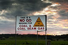
Agriculture on the Liverpool Plains is threatened by expanding coal exploration by BHP Billiton at Caroona and the China Shenhua Energy Company at Watermark, who are drilling with Santos for coal bed methane , a seam gas. Growing protest, led by the Caroona Coal action Group , led to a blockade of test wells. CCAG advocates an independent study of the impact of mining activities on groundwater prior to any mining activity.
Web links
Individual evidence
- ^ The Australian Encyclopedia Vol. V, Halstead Press, Sydney
- ↑ adb.anu.edu.au : Victor Crittenden: Ward, Frederick (Captain Thunderbolt) (1835 - 1870) , Australian Dictionary of Biography, Volume 6
- ↑ ccag.org.au ( Memento of the original from April 2, 2012 in the Internet Archive ) Info: The archive link was automatically inserted and not yet checked. Please check the original and archive link according to the instructions and then remove this notice. : SOS Liverpool Plains , accessed March 11, 2012
- ↑ theland.farmonline.com.au ( Memento of the original from July 31, 2008 in the Internet Archive ) Info: The archive link was inserted automatically and has not yet been checked. Please check the original and archive link according to the instructions and then remove this notice. : The Land - Caroona keeps BHP from door , in English, accessed March 11, 2012
Coordinates: 30 ° 23 ′ 5 ″ S , 149 ° 20 ′ 43.4 ″ E


