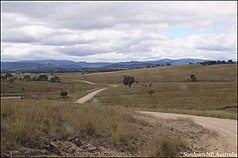
Sundown National Park
| Sundown National Park | ||
|---|---|---|
| Sundown National Park | ||
|
|
||
| Location: | Queensland , Australia | |
| Specialty: | Gorges and waterfalls | |
| Next city: | Stanthorpe | |
| Surface: | 126.47 km² | |
| Founding: | 1977 | |
| Hikers in the park | ||
The Sundown National Park (English: Sundown National Park ) is a national park in the southeast of the Australian state of Queensland . It is 198 kilometers southwest of Brisbane and 45 kilometers southwest of Stanthorpe , right on the border with New South Wales .
National nature
The park has many gorges and several mountain peaks over 1,000 meters. This is where the Severn River , which is considered to be the source of the Darling River , and thus the longest river system in Australia, has its source . The river has dug a 10-kilometer canyon in the hard magma rock. Some tributaries of the Severn River have also dug canyons in the rock and have waterfalls.
There are a number of minerals in the area. Before the designation of the national park, molybdenite , arsenic , tungsten , copper and tin were digested here. The abandoned mines are considered contaminated. There is a redevelopment plan in place and access to these places is limited. Shellfish fossils can be found on the 1,038-meter-high summit of Mount Donaldson . The magma rock, which forms the basis for most of the park area, is crossed by granite veins, which led to fault lines in the rock.
Flora and fauna
There is mainly sparse forest in Sundown National Park. In the north, the stringybark ( Eucalyptus tenella ), the yellow box ( Eucalyptus melliodora ), the brown box and the tenterfield woolybutt ( Eucalyptus banksii ) are particularly common. Along the rivers are the Red River Gum ( Eucalyptus cladocalyx ), the River Oak, the tea tree and the cylinder cleaner . Some parts of the park have been cut down to make grazing land for sheep.
At least 150 species of birds have been counted in the park.
Facilities and access
There is a campsite at Broadwater in the southeast of the park. In addition, wild camping is permitted in this national park. There are also a number of hiking trails of varying lengths.
The Sundown National Park can be reached via the Bruxner Highway ( Mingoola exit ).
Web links
Individual evidence
- ↑ Australian Government - CAPAD 2010 ( MS Excel ; 170 kB), DSEWPaC , accessed on October 7, 2012 (English)
- ↑ Australian Government - CAPAD 1997 ( MS Excel ; 93 kB), DSEWPaC , accessed on October 7, 2012 (English)
- ^ A b Steve Parish: Australian Touring Atlas . Steve Parish Publishing. Archerfield QLD 2007. ISBN 978-1-74193-232-4 . P. 9
- ↑ a b c d Peter Shilton: Natural Areas of Queensland . Goldpress, Mount Gravatt, Queensland 2005, ISBN 0-9758275-0-2 , pp. 202-205 (accessed July 2, 2011).
- ↑ a b c About Sundown . Department of Environment and Resource Management. June 9, 2011. Retrieved July 1, 2011.


