Mount Bauple National Park
| Mount Bauple National Park | ||
|---|---|---|
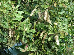
| Bauple nut | ||
|
|
||
| Location: | Queensland , Australia | |
| Specialty: | Natural occurrence of the Bauple nut ( Macadamia integrifolia ) | |
| Next city: | Bauple | |
| Surface: | 5.47 km² | |
| Founding: | 1935 | |
The Mount Bauple National Park (English: Mount Bauple National Park ) is a national park in the southeast of the Australian state of Queensland . It is 190 km north of Brisbane and around 40 km south of Maryborough .
The park is for scientific purposes only and is not open to the public.
flora
A natural occurrence of the Bauple nut ( Macadamia integrifolia ) is protected there. Although this plant is cultivated in many parts of Queensland and abroad, wild walnut trees of this species are extremely rare. The wild Bauple Nut is as vulnerable (ger .: vulnerable classified). The economic importance of the cultivated plant makes the preservation of the wild form appear particularly important.
Driveway
The park is located between the Bruce Highway in the east and the Mary River in the west at the level of the Bauple settlement .
Individual evidence
- ↑ Australian Government - CAPAD 2010 ( MS Excel ; 170 kB), DSEWPaC , accessed on October 7, 2012 (English)
- ↑ Australian Government - CAPAD 1997 ( MS Excel ; 93 kB), DSEWPaC , accessed on October 7, 2012 (English)
- ^ A b Steve Parish: Australian Touring Atlas . Steve Parish Publishing. Archerfield QLD 2007. ISBN 978-1-74193-232-4 . P. 9
- ↑ Queensland Parks and Wildlife Service : Mount Bauple National Park (Scientific) - Management Plan (PDF; 1.3 MB) 2011. Accessed October 30, 2012.

