Endeavor River National Park
| Endeavor River National Park | ||
|---|---|---|
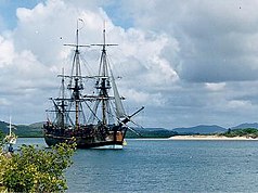
| Replica of the Endeavor in the mouth of the Endeavor River. In the background is the Endeavor River National Park | ||
|
|
||
| Location: | Queensland , Australia | |
| Specialty: | Sand dunes, mangrove forests, coastal heathland, estuary of the Endeavor River | |
| Next city: | Cooktown | |
| Surface: | 21.99 km² | |
| Founding: | 1975, expanded in 2006 | |
The Endeavor River National Park (English: Endeavor River National Park ) is a national park in the northeast of the Australian state of Queensland . It is located 1,561 kilometers northwest of Brisbane , immediately northeast of the urban area of Cooktown at the confluence of the Endeavor River in the Coral Sea .
history
The Endeavor, under the command of Lieutenant James Cook , ran aground on June 11, 1770 on what is now known as the Endeavor Reef , which is located off Cape Tribulation . The ship threatened to sink, the crew escaped to the mainland and only a day later could it be pulled to the bank of the river for repairs. The natives called this river Wabalumbaal . The river was later named after the ship name Endeavor River . The national park in turn got its name after the river.
Since the ship repair lasted until August 4th, the naturalists Joseph Banks and Daniel Solander collected numerous specimens of the "Australian" flora from this area, which they took to the Royal Botanic Gardens in England. Sydney Parkinson was the first to illustrate Australian Aborigines who were found nearby, as well as the plants and animals that were collected. Kangaroos then got their English name (Kangaroo), which was borrowed from the language of the local Aborigines, the Guugu Yimithirr .
Terrain forms
In today's national park there are sand dunes, freshwater wetlands, mangrove forests , coastal heathland, as well as the estuary and the lower reaches of the Endeavor River.
Flora and fauna
The flora and fauna that the English gathered and sighted in this area in 1770 can still be found in the national park today. These include B. Striped possums ( Dactylopsila trivirgata ), short-headed gliding pouches , brushtail pouches , bats, bandicoots , honey eaters and parrots. Saltwater crocodiles and various species of frogs can be found in the mouth of the Endeavor River .
Facilities and access
There are no tent sites in the park and wild camping is not allowed.
Cooktown is accessible via the Mulligan Highway . Most parts of the national park are only accessible by boat.
Web links
- Official site of the park (English)
Individual evidence
- ↑ Australian Government - CAPAD 2010 ( MS Excel ; 170 kB), DSEWPaC , accessed on January 7, 2013 (English)
- ↑ Australian Government - CAPAD 1997 ( MS Excel ; 93 kB), DSEWPaC , accessed on January 7, 2013 (English)
- ^ Steve Parish: Australian Touring Atlas . Steve Parish Publishing. Archerfield QLD 2007. ISBN 978-1-74193-232-4 . P. 15
- ↑ a b c d e Endeavor River National Park . Department of Environment and Resource Management. Retrieved November 7, 2012

