Pipeclay National Park
| Pipeclay National Park | ||
|---|---|---|
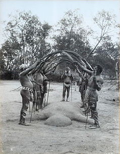
| Bora ceremony (1898) | ||
|
|
||
| Location: | Queensland , Australia | |
| Specialty: | Bora ring | |
| Next city: | Tin Can Bay | |
| Surface: | 14.6 ha | |
| Founding: | 1963 | |
The Pipeclay National Park (English: Pipeclay National Park ) is a national park in the southeast of the Australian state of Queensland . It is located 165 kilometers north of Brisbane , 40 kilometers northeast of Gympie and 5 kilometers south of Tin Can Bay near Great Sandy National Park .
The park is administered by the Queensland government along with the Great Sandy Region Aboriginal Heritage Advisory Committee . Access is only possible with a special permit.
history
The park was established in 1963 to protect a boraring known as the Little Bora Ring . This ring was particularly important for the Aborigines of Fraser Island and the adjacent mainland, as only there, according to their belief, could the highest level of human existence be achieved. The last initiation took place there in 1865. Since 1962 the square has been known to the Queensland Government as an important cultural site. Its diameter was 21-23 meters and its mound was 15-18 cm high. The park was named after the clay that is found in a nearby stream and by European settlers for molding clay pipes (ger .: clay pipe was used).
National nature
The small park is located on the coastal plain south of Tin Can Bay Inlet , a river valley that sank into the Pacific as the sea level rose .
flora
In the Pipeclay National Park there is heathland and light forest with Leptospermum flavenscens and Leptospermum semibaccatum , as well as Banksia oblongifolia .
Facilities and access
There are no tourist facilities in the park. The boraring can still be seen.
The place Tin Can Bay is of Gympie from the state road 15 to reach (57 km). The park is to the east of the Cooloola Cove district at the end of Vendetta Avenue .
Individual evidence
- ↑ Australian Government - CAPAD 2010 ( MS Excel ; 170 kB), DSEWPaC , accessed on October 7, 2012 (English)
- ↑ Australian Government - CAPAD 1997 ( MS Excel ; 93 kB), DSEWPaC , accessed on October 7, 2012 (English)
- ^ A b Steve Parish: Australian Touring Atlas . Steve Parish Publishing. Archerfield QLD 2007. ISBN 978-1-74193-232-4 . P. 9
- ↑ a b c d e Pipeclay National Park (PDF; 1.9 MB) Queensland Parks and Wildlife Service. August 2000. Retrieved January 7, 2013.

