Culgoa Floodplain National Park
| Culgoa Floodplain National Park | ||
|---|---|---|
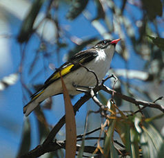
| Grant honeyeater ( Grantiella picta ) | ||
|
|
||
| Location: | Queensland , Australia | |
| Specialty: | Alluvial forests and light woodland | |
| Next city: | Goodooga | |
| Surface: | 619 km² | |
| Founding: | 2008 | |
The Culgoa Floodplain National Park (English Culgoa Floodplain National Park ) is a national park in the south of the Australian state of Queensland .
location
It is 627 kilometers west of Brisbane and 150 kilometers southwest of St. George , right on the border with New South Wales .
The park is located in the area of the former Byra Station sheep breeding station . In the southeast it borders on the eponymous Culgoa River . To the south, on the other side of the border, is Culgoa National Park . The Nebine Creek , a tributary of the Culgoa River, flows through the western part of the park.
The national parks Narkoola and Binya are in the neighborhood .
Flora and fauna
In the floodplains of the Culgoa River there is light forest with black box ( Eucalyptus largiflorens ) and grasses as undergrowth. On the plains in the middle there are different types of acacia , such as brigalow ( Acacia harpophylla ) and gidgee ( Acacia cambagei ), while in the mountains in the west there are more mulga and pterocarpus .
With 150 species of birds, the park is an Eldorado for bird watchers. So there are 10 different types of honey eaters , such as the Grant-Honigfresser ( Grantiella picta ), and all six Australian species of forest swallows .
Culture
Fragments of stone tools and old fireplaces remind the visitor of the long history of Aboriginal settlements in this area.
Facilities and access
There are no hiking trails or campsites in this area. However, wild camping in the park is allowed.
From the Castlereagh Highway ( lever exit ), turn southwest, cross the border into New South Wales and after 39 kilometers you will reach the village of Goodooga . From there you drive the unpaved Brenda Road to the northwest and cross the Birrie River . After 22 kilometers, Brenda is reached on the Culgoa River. You cross the border to Queensland and turn left after the settlement of Tara , direction Lyra. This road leads to the east part of the park. It is only passable in dry weather. The use of an all-wheel drive vehicle is recommended.
A second route leads from the Mitchell Highway , 28 kilometers south of Cunnamulla , 68 kilometers southeast to Noorama station . From there, an unpaved road leads east and south-east 72 kilometers across the Bundaleer to the Tego station on the western edge of the national park.
Web links
- Official site of the park (English)
Individual evidence
- ↑ a b Australian Government - CAPAD 2010 ( MS Excel ; 170 kB), DSEWPaC , accessed on October 7, 2012 (English)
- ^ A b c d Steve Parish: Australian Touring Atlas . Steve Parish Publishing. Archerfield QLD 2007. ISBN 978-1-74193-232-4 . P. 8 + 19
- ↑ a b c d e Culgoa Floodplain National Park . Department of Environment and Resource Management. Retrieved October 31, 2012

