Lamington National Park
| Lamington National Park | ||
|---|---|---|
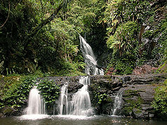
| Elabana Falls | ||
|
|
||
| Location: | Queensland , Australia | |
| Specialty: | Rainforest | |
| Next city: | Nerang - Surfers Paradise | |
| Surface: | 205.9 km² | |
| Founding: | 1915 | |
| Box Log Falls in Lamington National Park | ||
The Lamington National Park (English Lamington National Park ) is located in the southeast of the Australian state of Queensland on the border with New South Wales . The park was established in July 1915 and is one of the in the UNESCO list of World Heritage standing Gondwana Rainforests .
geology
The landscape of Lamington Park is the result of geological changes that began in the Paleozoic Era more than 225 million years ago when the continent of Pangea was divided into two continents, Laurasia and Gondwana . Gondwana broke up 120 million years ago. South America and Africa separated and then Madagascar and the subcontinent India . The Australian plate hit the Antarctic plate 65 to 70 million years ago and drifted northward. Small pieces of the plate moved eastward and this resulted in New Zealand and New Caledonia .
While the Australian plate drifted northward about 5 to 7 centimeters annually, it moved over a hotspot . The Lamington area drifted over the hotspot 20 to 23 million years ago. Volcanoes formed, such as on Focal Peak near Mount Barney. The Focal Peek was later covered by the lava of a large volcano that was located above what is now Mount Warning . Numerous eruptions took place and lava flowed as far as the area of Lismor in New South Wales in the south and Tambourine in the north. In the area around Binna Burra, volcanic ash and rhyolite rock were deposited. The erosion of the lava created fertile soil, while the rhyolite eroded soils are less fertile. When the volcanic activity ended, water flowed over the resulting rock, which carved itself into the surface, creating waterfalls, deep gorges, different mountain peaks and rugged rocks.
Today the consequences of the geological change are largely under vegetal green. Tamborine, Springbrook, Beechmont and Lamington form the relics of the northern flank of a volcano. The rim of the crater shows up as a remnant on Mount Warning. The Tweed Valley, formed by severe erosion, shows the remains of a weathered caldera on the eastern flank of the old volcano. The southern cliffs of Lamington continue to New South Wales in a large circle and mark the end of the volcanic crater.
Flora and fauna
The approximately 206 km² national park is the largest subtropical jungle in Australia. There are over 500 waterfalls and lush subtropical flora and fauna . The populations of Pennant Parakeets , King Parakeets and Black Cockatoos are particularly large here .
It is named after Charles Cochrane-Baillie, 2nd Baron Lamington .
Web links
- Official website
- Canopy Walk ( Memento from July 6, 2008 in the Internet Archive )
Individual evidence
- ↑ nprsr.qld.gov.au : Nature, culture and history , in English, accessed on November 23, 2012


