
Mount Warning
| Mount Warning (Wollumbin) | ||
|---|---|---|
 Mount Warning, recognizable as a silhouette, viewed from Point Danger . |
||
| height | 1156 m | |
| location | New South Wales , Australia | |
| Mountains | Great dividing range | |
| Coordinates | 28 ° 23 '53 " S , 153 ° 16' 18" O | |
|
||
| rock | Volcanites | |
| Last eruption | 23 million years | |

The Mount Warning (in the language of Aborigines Wollumbin is called) the central volcanic vent of the Tweed Volcano , one of the largest volcanoes in Australia and the Southern Hemisphere. The 1156 meter high mountain is 6 kilometers from Uki and 14 kilometers from Murwillumbah in the state of New South Wales , near the Queensland border .
Surname
The name Mount Warning was given by the British navigator James Cook on his expedition on May 16, 1770, when he was sailing along the coast. Cook wanted to point out to ships coming after him that there are dangerous waters with reefs there. In the Aboriginal language of the Bandjalung-Yugambeh, the "Wollumbin" is the patriach of the mountains. There are also other interpretations such as cloud catchers or weather makers.
geology

The Tweed Volcano erupted about 23 million years ago with lava , rhyolite, and ash rain. A large volcanic complex with a crater height of 1900 meters was created over a period of 3 million years. There were also periods of rest during the long period. Today the volcano's crater is largely eroded . The rim of the crater can still be seen in the Tweed Valley , where it reaches a height of 1000 meters. In the center of the shield volcano is Mount Warning today. The eruptions of the volcano took place in three phases, initially lava flowed out, then the explosive phase followed, in which rhyolite was ejected. In the final phase, lava flowed out again. In addition to the central vent, today's Mount Warning, there were also side vents.
Today, mountains and mountain ranges such as the Border Ranges and McPherson Range and the high plateaus of Tambourine Mountain , Lamington Plateau and Springbrook Plateau lie in the area of the Tweed Volcano .
Mount Warning / Wollumbin Trail
A 4.4 kilometer hiking trail leads from Breakfast Creek to the mountain top. More than 60,000 people take this route every year. The hike requires a certain level of fitness. Since the mountain is used by the local Aborigines for ceremonies, consideration is requested.
The hiking trail was badly damaged by heavy rain on January 26, 2013 and closed by the national park administration. It was only released on September 23, 2013.
Mount Warning National Park
The original Mount Warning National Park, in which Mount Warning is located, was expanded in 2009 and renamed Wollumbin National Park . Today it covers an area of 4117 ha . The National Park is part of the UNESCO - World Heritage Gondwana Rainforests .
Trivia
Due to its very eastern location and its height, Mount Warning is the first point on the Australian mainland to be illuminated by sunlight in the morning. With the title Mt Warnings Youth Bird , the mountain has also entered newer Australian songs.
photos

Mount Warning can be seen in the background.

Summit trail

View from Beechmont (Queensland)
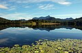
View from Clarrie Hall Dam

Evening mood at Clarrie Hall Dam
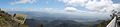
Panorama from the top of Mount Warning


Individual evidence
- ↑ gnb.nsw.gov.au : Geographical Names Register Exakt , in English, accessed on November 3, 2013
- ↑ southseas.nla.gov.au : Cook's Journal: Daily Entries , in English, accessed on November 3, 2013
- ↑ a b c lonelyplanet.com ( Memento of the original from December 3, 2013 in the Internet Archive ) Info: The archive link was inserted automatically and has not yet been checked. Please check the original and archive link according to the instructions and then remove this notice. : Mt Warning National Park , in English, accessed November 3, 2013
- ↑ bigvolcano.com.au : The Lost World , in English, accessed November 3, 2013
- ↑ goldcoast.com.au : Mackenzie Ravn: Mt Warning hikers disregard closure , March 26, 2013, in English, accessed November 3, 2013
- ↑ echo.net.au : Luis Feliu: Mt Warning track re-opened , in English, accessed on November 3, 2013
- ↑ commungroundaustralia.com ( Memento of the original from November 10, 2013 in the Internet Archive ) Info: The archive link was automatically inserted and not yet checked. Please check the original and archive link according to the instructions and then remove this notice. : About Johnny Abegg , accessed November 3, 2013