Binya National Park
| Binya National Park | ||
|---|---|---|
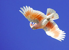
| Inca cockatoo ( Lophochroa leadbeateri ) | ||
|
|
||
| Location: | Queensland , Australia | |
| Specialty: | Mulga Bush | |
| Next city: | 90 km from Cunnamulla | |
| Surface: | 137.10 km² | |
| Founding: | 2009 | |
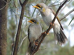
| Yellow-fronted babbler ( Manorina flavigula ) | ||
The Binya National Park (English Binya National Park ) is a 137 square kilometer national park in Queensland , Australia on the banks of the Warrego River .
location
It is located in the South West region about 750 kilometers west of Brisbane and 90 kilometers south of Cunnamulla . From here you can reach the park via the Mitchell Highway , which runs after 80 kilometers, about 20 kilometers from the border with New South Wales , at a distance of 5 kilometers along the eastern border. There are no visitor facilities in the park itself.
In the neighborhood are the national parks Narkoola , Culgoa Floodplain and Currawinya .
Flora and fauna
The park protects the mulga shrub , which is widespread in the arid areas of Australia , but which has been largely cleared in southwest Queensland for sheep and cattle breeding. The park is home to 25 different bird species, including yellow- fronted chatterbox ( Manorina flavigula ), brown-throated honeyeater ( Acanthagenys rufogularis ) and blue-eared honeyeater ( Entomyzon cyanotis ), as well as the endangered Inca cockatoo ( Lophochroa leadbeateri ).
Individual evidence
- ↑ a b Australian Government - CAPAD 2010 ( MS Excel ; 170 kB), DSEWPaC , accessed on October 7, 2012 (English)
- ↑ OSM - Binya National Park , OpenStreetMap , accessed on October 7, 2012 (English)
- ^ Species List. Queensland Parks and Wildlife Service , accessed October 7, 2012


