South West Queensland
| South West Queensland | |
 Location map of the regions of Queensland |
|
| structure | |
| State : |
|
| State : |
|
| LGA : | Maranoa Region , Balonne Shire , Paroo Shire , Murweh Shire , Bulloo Shire , Quilpie Shire . |
| Dates and numbers | |
| Area : | 319,808 km² |
| Residents : | 26,489 |
| Population density : | 0.08 inhabitants / km² |
Coordinates: 26 ° 24 ' S , 146 ° 15' E
South West Queensland is a remote region in Queensland , Australia , covering an area of 319,808 km². The region lies south of Central West Queensland and west of the Darling Downs and includes the Maranoa District and parts of the Channel Country . The area is known for its herds of cattle, cotton farms , opals, and oil and gas deposits .
The Maranoa Division is the district there for the election of the government of Australia. LGAs are the Maranoa Region , the Balonne Shire , Paroo Shire , Murweh Shire , Bulloo Shire, and Quilpie Shire . South West Queensland has a population of 26,489 people.
In the region, the information is transmitted by the ABC Western Queensland , a radio station.
history
Aboriginal
The indigenous society there traded in everyday objects and promoted social cohesion. In the area of South West Queensland the plant Duboisia hopwoodii grew with which it traded and with which the traditional chewing tobacco was made.
Europeans
The eastern areas of the region around the lower Warrego River were first explored by Thomas Livingstone Mitchell in 1845. Settlement by dairy farmers only began after William Landsborough's expedition in 1862.

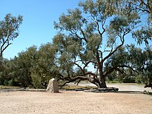
In 1860 Robert O'Hara Burke and William John Wills came on the Burke and Wills Expedition from Melbourne to the Gulf of Carpentaria in this area to explore large areas inland Australia that were not known to the European settlers. An important meeting point that the explorers used was a depot at the Bullah Bullah waterhole on Cooper Creek . After they did not reach the northern coastline because of the mangrove swamps in the mouth of the Flinders River and their supplies were running out, the four expedition members decided to turn back. One member of the expedition died on the way back, the other three were tragically killed because they missed a rescue expedition at the meeting point on Copper Creek by only hours.
In the western parts of this Western region, an annual average of 150 mm of rain falls. Further east around St. George, an average of 500 mm falls per year. The low water resources hindered early dairy farming. After the Great Artesian Basin was discovered and developed through drilling, it was possible to farm sheep and cattle.
Cobb & Co set up a carriage manufacture in Charleville in 1893 when carriage services were developing in the region during the 1880s. Cobb & Co was Australia's most famous historic carriage company that transported passengers and mail overland. The carriages it made could carry eight passengers and were known for their resilience, stability and resilient suspension.
In 1922, Qantas flew regularly to Charleville for the first time.
geography

The northern extension of the Sturts Stony Desert in South West Queensland is around an area known as Cameron Corner . Parts of the Cooper Basin are in this region. This sedimentary basin contains the most important oil and natural gas deposits on the Australian continent. Near Roma at Hospital Hill, Australia's first natural gas strike was made. Oil was found in the region in 1961. The Eromanga Basin with its oil deposits is also located in South West Queensland. Economically usable quantities of natural gas were discovered in 1976 and oil in 1978. The Tookoonooka crater , a large impact crater, is located there, but it is not visible on the surface of the earth.
Important settlements
The major cities in South West Queensland are Charleville , Roma , Augathella , Windorah , Thargomindah , St George and Cunnamulla . Cunnamulla has the largest cotton rail loading station on the Queensland rail network. Australia's largest cotton farm, Cubbie Station at St George, covers 93,000 hectares .
Smaller towns are Amby, Injune , Jackson , Mitchell , Muckadilla, Mungallala, Surat , Wallumbilla , Yuleba , Alton, Bollon , Boolba, Dirranbandi , Hebel , Mungindi , Nindigully , Thallon , Coongoola, Eulo , Humeburn, Tuen, Wyandra , Yowah , Bakers Bend, Morven , Nive, Sommariva, Thargomindah , Hungerford , Noccundra , Nockatunga, Norley, Oontoo, Quilpie , Adavale , Cheepie, Eromanga and Toompine. Cooladdi is a ghost town with six inhabitants.
Rivers
The waterways that traverse South West Queensland are the Warrego , Maranoa , Merivale , Balonne and its tributaries such as the Bokhara River , Culgoa , Wilson and Cooper Creek . The Balonne River is used for an extensive irrigation network. The Bulloo River System is the only closed river system in Australia.
National parks
Numerous areas have been declared national parks , the Alton National Park , Chesterton Range National Park , Culgoa Floodplain National Park , Currawinya National Park , Diamantina National Park , Idalia National Park , Lake Bindegolly National Park , Mariala National Park , Thrushton National Park and Tregole National Park . Bowra Sanctuary is a nature reserve near Cunnamulla managed by the Australian Wildlife Conservancy .
transport

Major roads in the region include the Mitchell Highway , which runs out of the New South Wales outback , and the Balonne Highway , which runs east from St George to Cunnamulla. The Warrego Highway runs east-west through the north of the region. The northern tip of the Castlereagh Highway crosses the southeast of the region and ends at St George. The Carnarvon Highway and the Diamantina Development Road , which are gradually being paved, run through St George .
Seven airports are Dirranbandi Airport , Roma Airport , St George Airport , Charleville Airport , Thargomindah Airport , Cunnamulla Airport and Quilpie Airport . In 1888 the Western Railway reached Charleville.
A regional train from Cunnamulla opened in 1898. Today the Westlander train runs from Brisbane to Charleville, while the South Western Railway runs via Thallon to the southeast corner of the region.
environment
The area's bioregions consist of Mulgaland. Mulga grows either as shrubbery or as a small tree that spreads in dry areas in the arid outback of Australia. There is an isolated population of Rufous-crowned Emu-wren that live in areas of Spinifex overgrown land. The Dingo Fence ran through the region, the world's longest fence.
The region is covered in red, brown and gray clay. Red sand and earth dominate, which is typical for arid Australia.
opal
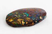
The first Australian opal was found in Adavale . The ghost town of Yowah was built on an opal field when opal mining began in the 1870s. Opals have also been found in Quilpie , Eulo, and northern New South Wales.
Individual evidence
- ^ A b National Regional Profile: South West . Australian Bureau of Statistics. November 2, 2011. Retrieved January 29, 2012.
- ^ Edwards William Howell: An Introduction to Aboriginal societies , 2nd edition, Cengage Learning Australia, 1988, ISBN 1-876633-89-1 , p. 50 (accessed January 29, 2012).
- ↑ a b Cunnamulla . In: Queensland Places . Center for the Government of Queensland. Retrieved January 29, 2012.
- ↑ Burke and Wills Dig Tree . In: CHIMS . Department of Environment and Resource Management. April 4, 2011. Archived from the original on January 26, 2012. Info: The archive link was automatically inserted and not yet checked. Please check the original and archive link according to the instructions and then remove this notice. Retrieved January 29, 2012.
- ↑ The Burke and Wills Expedition: Tragedy and Triumph . In: State Library of Queensland Publications . Department of Public Works. August 30, 2011. Retrieved January 29, 2012.
- ↑ a b c d e f g h Agriculture - Statistics - South West . In: Australian Natural Resources Atlas . Department of Sustainability, Environment, Water, Population and Communities. May 25, 2009. Archived from the original on June 2, 2011. Info: The archive link was inserted automatically and has not yet been checked. Please check the original and archive link according to the instructions and then remove this notice. Retrieved January 29, 2012.
- ↑ a b Chris J. Stokes, Ryan R. McAllister, Andrew J. Ash & John E. Gross: Changing Patterns of Land Use and Tenure in Dalrymple Shire, Australia . In: Kathleen A. Galvin, Jim Ellis, Robin S. Reid, Roy H. Behnke, N. Thompson Hobbs (eds.): Fragmentation in Semi-Arid and Arid Landscapes: consequences for human and natural systems . Springer, 2008, ISBN 1-4020-4905-6 , p. 107 (accessed January 29, 2012).
- ↑ H3875 Horsedrawn vehicle, Cobb & Co mail and passenger coach, timber / metal / leather, made by Cobb & Co Coach and Buggy Factory, Charleville, Queensland, Australia, 1890 . In: Powerhouse Museum Collection . NSW Government. Retrieved January 26, 2012.
- ^ Petroleum Geology of South Australia Volume 4 - Cooper Basin . Government of South Australia. November 8, 2011. Retrieved January 25, 2012.
- ^ Ian Castles: Year Book of Australia . Australian Bureau of Statistics, Canberra 1990, p. 10 (Accessed January 25, 2012).
- ↑ Eromanga Basin - Geological Overview . NSW Department of Primary Industries. Retrieved January 29, 2012.
- ^ Fidelis Rego: Offers made for Cubbie Station cotton farm . In: ABC News , Australian Broadcasting Corporation, December 18, 2009. Retrieved January 29, 2012.
- ↑ Cooladdi . Murweh Shire Council. Retrieved January 28, 2012.
- ^ Char Speedy, "The Bulloo River System: life along the Bullo River 1880-1920s," Watson, Ferguson and Co ISBN 0-646-42858-6
- ↑ a b Environmental Protection Agency (Queensland) : Heritage Trails of the Queensland Outback . State of Queensland, 2002, ISBN 0-7345-1040-3 , p. 10 (Retrieved January 26, 2012).
- ↑ Dingo . New South Wales Office of Environment and Heritage. April 15, 2011. Retrieved January 26, 2012.
- ^ RA Perry, David W. Goodall: Arid land ecosystems: structure, functioning, and management, Volume 1 . Cambridge University Press, Cambridge, United Kingdom 1979, ISBN 0-521-21842-X , p. 148 (accessed January 29, 2012).
- ↑ Small town gem festival draws masses . In: ABC Western Queensland , Australian Broadcasting Corporation, July 18, 2008. Retrieved January 29, 2012.


