Currawinya National Park
| Currawinya National Park | ||
|---|---|---|
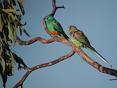
| Multi- colored parakeet pair in Currawinya National Park | ||
|
|
||
| Location: | Queensland , Australia | |
| Specialty: | Steppe, Paroo River , wetlands | |
| Next city: | Hungerford | |
| Surface: | 1,548.7 km² | |
| Founding: | 1991 | |
The Currawinya National Park (English: Currawinya National Park ) is a national park in the southwest of the Australian state of Queensland .
location
It is 828 km west of Brisbane and immediately northwest of the city of Hungerford on the border with New South Wales .
National nature
The park belongs to the Mulga Lands bioregion and consists of dry, sandy plains with small trees and shrubbery. The Paroo River flows through the eastern part of the park.
history
In the park you will find many important Aboriginal cult sites , which indicate the long period of settlement of the indigenous people in this area and their use of the wetlands.
The area was pasture land before it was designated a national park. In 1991 the Queensland Government acquired two properties, Currawinya and the Caiwarro Settlement . Remains of the settlement, machines and a river dike can be seen to this day.
Environmental aspects
The Lake Numalla - a freshwater lake - and the Lake VYARA - a salt lake - are the world's important wetlands for the Ramsar Convention listed. Both lakes provide important habitats for waterfowl and resting places for migratory birds that cross the interior of Australia during droughts. 200 species of birds have been counted in the park.
Most of the park is in the Paroo Floodplain and Currawinya Important Bird Area , which has been designated by BirdLife International because of its importance for large numbers of waterfowl when the conditions are suitable.
Facilities and sights
Fishing, canoeing, and swimming are popular pastimes in the park.
An important sight is the 25 km² enclosure for rabbit-nosed bilbies , which is secured against predators with a fence. The enclosure was opened in 2001. Captive-bred and released rabbit-nosed whiskers roam this secure area.
Web links
Individual evidence
- ↑ Australian Government - CAPAD 2010 ( MS Excel ; 170 kB), DSEWPaC , accessed on October 7, 2012 (English)
- ↑ Official Park Website , Queensland Parks and Wildlife Service , accessed October 7, 2012
- ^ Steve Parish: Australian Touring Atlas . Steve Parish Publishing. Archerfield QLD 2007. ISBN 978-1-74193-232-4 . P. 19
- ↑ a b c d Currawinya National Park: Nature, culture and history . Department of Environment and Resource Management. August 27, 2009. Archived from the original on August 7, 2010. Info: The archive link was automatically inserted and not yet checked. Please check the original and archive link according to the instructions and then remove this notice. Retrieved October 24, 2010.
- ↑ a b c Environmental Protection Agency (Queensland): Heritage Trails of the Queensland Outback . State of Queensland, 2002, ISBN 0-7345-1040-3 , p. 113.
- ↑ a b Currawinya National Park . Tourism Queensland. Retrieved October 24, 2010.
- ↑ IBA: Paroo Floodplain & Currawinya . In: Birdata . Birds Australia. Retrieved September 13, 2011.

